
Existed: 1926 – present WI WIS 53 → Constructed 1926 | States: Wisconsin, Minnesota Length 648.6 km | |
 | ||
South end: US 14 / US 61 / WIS 16at La Crosse, WI Counties: WI: La Crosse, Trempealeau, Eau Claire, Chippewa, Barron, Washburn, DouglasMN: St. Louis, Koochiching | ||
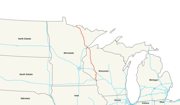
U.S. Route 53, or U.S. Highway 53 (U.S. 53), is a north–south U.S. highway that runs for 403 miles (649 km) from La Crosse, Wisconsin to International Falls, Minnesota. It is the primary north–south route in northwestern Wisconsin, serving as a vital link between I-94 at Eau Claire, Wisconsin and the city of Duluth, Minnesota. The entire route from Eau Claire to the city limits of Superior, Wisconsin is a four lane divided highway. The highway's northern terminus is at the Fort Frances-International Falls Bridge in International Falls, Minnesota, at the Canada–US border. Its southern terminus is in La Crosse, Wisconsin, at U.S. Highway 14.
Contents
- Map of US 53 United States
- Wisconsin
- Minnesota
- Designations
- History
- Four lane expansion project from Virginia to Cook
- Relocation of US 53 between Eveleth and Virginia
- Falls to Falls Corridor
- References
Map of US-53, United States
Wisconsin
U.S. Highway 53 begins at its southern terminus with a junction at U.S. 14, U.S. 61, and Wisconsin Highway 16 in downtown La Crosse. From there, U.S. 53 crosses Interstate 90 and becomes a freeway bypass of Onalaska and Holmen before proceeding north to Eau Claire as a two-lane roadway. The interchange with Interstate 94 at Eau Claire begins a freeway / expressway stretch for U.S. 53 north to the city limits of Superior. The recently built (circa 2006) freeway in Eau Claire, bypasses most of the city, alleviating congestion on the original route (signed now as both "Business U.S. 53" and Hastings Way.) Business U.S. 53 / Hastings Way is a mix of grade-separated interchanges and at-grade intersections, and is routed through Eau Claire, passing within about 1-mile (1.6 km) of downtown Eau Claire. Other smaller towns between Eau Claire and Superior (Solon Springs and Minong) were bypassed in a similar manner.
Wisconsin's first single-point urban interchange is found along the U.S. 53 bypass of Eau Claire, at its interchange with U.S. 12, in Altoona. This interchange received the 2005 Outstanding Highway Construction award from the Bureau of Project Development.
U.S. 53 continues as a freeway north of Eau Claire past Chippewa Falls to Rice Lake, where it then becomes an expressway with only two grade-separated interchanges (one at Wisconsin Highway 70 near Spooner and one at Wisconsin Highway 13, immediately southeast of Superior). U.S. 53 has a partial grade-separated interchange with U.S. 2 at South Range, but traffic turning onto U.S. 2 eastbound must take a U-turn at an at-grade crossover past the interchange.
After passing through the city of Superior as a four-lane city surface street (East Second Street) for a 5-mile (8.0 km) stretch, U.S. 53 then approaches the Saint Louis Bay. U.S. 53 then runs together with Interstate 535 and crosses the bay via the John Blatnik Bridge into Minnesota.
Minnesota
U.S. Highway 53 enters the state at the city of Duluth on the John Blatnik Bridge over the Saint Louis Bay. U.S. 53 is concurrent with I-535 for 2.8 miles (4.5 km) as it enters Minnesota.
U.S. 53 / I-535 has an interchange with I-35 in Duluth, known locally as the "Can of Worms"; and features a pair of left exits from I-35, a stoplight, and lane drops over the I-35 bridge.
After its junction with I-35, U.S. 53 continues through Duluth on the recently upgraded Piedmont Avenue and Trinity Road for 3.5 miles (5.6 km).
U.S. 53 is then concurrent with State Highway 194 for six miles (10 km), from Trinity Road in Duluth to Lindahl Road in the city of Hermantown. This four-lane stretch of Highways 53 and 194 are also known as the Miller Trunk Highway in the cities of Duluth and Hermantown.
From Hermantown, the route proceeds north to the city of Virginia. The portion of the route from Duluth to Virginia is a four-lane expressway. U.S. 53 has a junction with State Highway 33 at the unincorporated community of Independence. Continuing northbound, U.S. 53 has an interchange with U.S. 169 in Virginia. Immediately north of Virginia, U.S. 53 has an interchange with State Highway 169 in Wuori Township.
U.S. 53 then proceeds northwest to International Falls, where it has a junction with U.S. 71 and State Highway 11.
U.S. Highway 53 in Minnesota passes through Saint Louis and Koochiching counties.
Legally, the Minnesota section of U.S. 53 is defined as unmarked legislative routes 106, 11, and 315 in Minnesota Statutes §§ 161.115(37), (246), and 161.114(2). U.S. 53 is not marked with these legislative numbers along the actual highway.
Designations
History
U.S. Highway 53 in Minnesota was completely paved by 1940.
The expressway section between Duluth and Virginia was constructed by 1970, except just north of Duluth. This section and a U.S. 53 bypass around Virginia were completed during the 1970s.
A new four-lane divided highway section of U.S. 53 in Duluth was constructed in 2004. This section of the route is known locally as Piedmont Avenue. Previously, from 1934 to 2004, this same section of U.S. 53 was a narrow two-lane roadway that had proceeded up the hill to a seven-legged intersection that had included Duluth's Skyline Parkway. Locally, this now-defunct infamous intersection, had been known for 70 years by the name "Seven Corners".
A new U.S. Highway 53 interchange with State Highway 169 in Wuori Township was built in 2006.
Four-lane expansion project from Virginia to Cook
A section of U.S. 53, from north of the city of Virginia to the south city limits of Cook, is under construction. This is part of a long range goal of providing a four-lane highway to Canada as part of the Falls-to-Falls Corridor. The new four-lane highway will be built in two stages with a total length of approximately 20 miles. The first stage from approximately County Road 307 to 0.25 miles south of County Road 652 (Goodell Road) was completed in 2009. Bids for the second stage will be taken late fall of 2011 with construction scheduled to begin the winter of 2012. It is anticipated that the construction project will be completed in the fall of 2013.
Relocation of U.S. 53 between Eveleth and Virginia
The proposed project is to abandon U.S. Highway 53 in the area of the United Taconite mine expansion and relocate the highway nearby. The affected area is about one mile in length; located in Saint Louis County between the cities of Eveleth and Virginia.
On May 5, 2010, Cliffs Natural Resources provided notice to the Minnesota Department of Transportation (Mn/DOT) that U.S. Highway 53 easement rights across the United Taconite Mine, per a 1960 agreement, would be terminated. United Taconite and Mn/DOT are in negotiations to provide seven years for the relocation of Highway 53 between Eveleth and Virginia. Based on current project development requirements, Mn/DOT believes seven years is an appropriate time frame for review, design, and construction of a highway project.
There are three rerouting options being proposed for Highway 53:
A route will be selected by 2013; construction will begin in 2015; and the project will be completed by 2017.
Falls-to-Falls Corridor
The Falls-to-Falls Corridor (officially The Falls-to-Falls Corridor—United States Route 53 from International Falls on the Minnesota/Canada border to Chippewa Falls, Wisconsin) is, by the United States federal government, a recognized trade corridor.
In the 1990s, the federal government listed the corridor as a priority for development. The primary development planned is infrastructure-related, specifically, a highway improvement project designed to spur economic development in northwestern Wisconsin and northeastern Minnesota by upgrading U.S. Highway 53 to full expressway standards from Chippewa Falls, Wisconsin to International Falls, Minnesota. Interstate Highway 535 forms the only section of the route that is part of the Interstate Highway System.
Wisconsin
With the exception of a 5-mile (8.0 km) stretch as a four-lane city surface street (East Second Street) in the city of Superior, the entire route within Wisconsin is completed to freeway or expressway standards. On the south end of the corridor, the connection to Interstate Highway 94 is a 7.5-mile (12.1 km) stretch through the Eau Claire-Chippewa Falls conurbation. After years of legal and political wrangling, the decision was made in the late 1990s to bypass the current route, rather than to upgrade the present highway to freeway standards. The northern half of this bypass, as far south as WIS 312 was opened to traffic in mid-2005. The southern half of the bypass, which includes a new pair of multilane bridges over the Eau Claire River, goes mostly through Altoona and includes new interchanges with WIS 312, U.S. Highway 12 and WIS 93. This project won multiple awards in 2005 and 2006. This section of the bypass was opened mid-morning on August 21, 2006.
Minnesota
Federal funding for the project in northern Minnesota was $940,000 in 2003 and nearly $600,000 in 2004. At present, with the exception of 3.5 miles (5.6 km) stretch within the city of Duluth (Piedmont Avenue and Trinity Road), the route is completed as expressway as far north as the north side of the city of Virginia, leaving approximately 90 miles (140 km) of the route as-yet incomplete. A section between Virginia and Cook was recently turned into a 4-lane highway.