
Country United States County Saint Louis Time zone Central (CST) (UTC-6) Zip code 55792 Local time Monday 8:54 PM | Elevation 1,437 ft (438 m) ZIP codes 55792 Population 8,661 (2013) | |
 | ||
Weather 8°C, Wind N at 5 km/h, 39% Humidity | ||
What good steel jobs mean to virginia minnesota
Virginia is a city in Saint Louis County, Minnesota, United States, on the Mesabi Iron Range. The population was 8,712 at the 2010 census. According to a water tower in the middle of town, the city's nickname is the "Queen City", or "Queen City of the North".
Contents
- What good steel jobs mean to virginia minnesota
- Map of Virginia MN USA
- History
- Geography
- Economy
- 2010 census
- 2000 census
- Notable people
- Points of interest
- Notable events
- Education
- Olcott Park
- Climate
- References
Map of Virginia, MN, USA
History
Virginia was laid out in 1892, and named after Virginia, the native state of a large share of the lumbermen in the area. A post office has been in operation at Virginia since 1893.
Geography
According to the United States Census Bureau, the city has a total area of 19.18 square miles (49.68 km2); 18.85 square miles (48.82 km2) is land and 0.33 square miles (0.85 km2) is water.
Economy
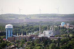
Virginia is located on the Mesabi Range, one of sub-regions within Minnesota's Iron Range. Virginia is considered the commerce center of the Mesabi Range.
2010 census
As of the census of 2010, there were 8,712 people, 4,242 households, and 2,019 families residing in the city. The population density was 462.2 inhabitants per square mile (178.5/km2). There were 4,738 housing units at an average density of 251.4 per square mile (97.1/km2). The racial makeup of the city was 94.7% White, 0.6% African American, 1.0% Native American, 0.5% Asian, 0.3% from other races, and 2.9% from two or more races. Hispanic or Latino of any race were 1.5% of the population.
There were 4,242 households of which 21.8% had children under the age of 18 living with them, 31.7% were married couples living together, 12.0% had a female householder with no husband present, 4.0% had a male householder with no wife present, and 52.4% were non-families. 46.3% of all households were made up of individuals and 20% had someone living alone who was 65 years of age or older. The average household size was 1.95 and the average family size was 2.74.
The median age in the city was 44.9 years. 18.9% of residents were under the age of 18; 9.3% were between the ages of 18 and 24; 21.8% were from 25 to 44; 27.9% were from 45 to 64; and 22% were 65 years of age or older. The gender makeup of the city was 47.9% male and 52.1% female.
2000 census
As of the census of 2000, there were 9,157 people, 4,333 households, and 2,270 families residing in the city. The population density was 486.1 people per square mile (187.7/km²). There were 4,692 housing units at an average density of 249.1 per square mile (96.2/km²). The racial makeup of the city was 95.17% White, 0.46% African American, 2.24% Native American, 0.55% Asian, 0.01% Pacific Islander, 0.17% from other races, and 1.40% from two or more races. Hispanic or Latino of any race were 0.80% of the population. 21.4% were of Finnish, 13.3% German, 9.9% Norwegian, 8.8% Italian and 7.8% Swedish ancestry.
There were 4,333 households out of which 22.5% had children under the age of 18 living with them, 38.4% were married couples living together, 10.7% had a female householder with no husband present, and 47.6% were non-families. 42.6% of all households were made up of individuals and 19.6% had someone living alone who was 65 years of age or older. The average household size was 2.00 and the average family size was 2.73.
In the city, the population was spread out with 19.0% under the age of 18, 9.4% from 18 to 24, 25.0% from 25 to 44, 23.3% from 45 to 64, and 23.2% who were 65 years of age or older. The median age was 43 years. For every 100 females there were 88.4 males. For every 100 females age 18 and over, there were 85.9 males.
The median income for a household in the city was $28,873, and the median income for a family was $43,419. Males had a median income of $38,834 versus $22,473 for females. The per capita income for the city was $17,776. About 10.6% of families and 15.9% of the population were below the poverty line, including 16.6% of those under age 18 and 10.0% of those age 65 or over.
Notable people
Points of interest
Notable events
Education
The public high school is Virginia High School, and the public elementary schools are Parkview Learning Center (early childhood programs through second grade) and Roosevelt Elementary (grades three through six). The higher education institution for the city is Mesabi Range Community and Technical College. The Virginia Public Library is also featured as an educational place for people of all ages. Marquette Catholic School is a private elementary school operated by the Duluth Diocese. Northland Learning Center, a cooperative alternative school for students with disciplinary problems or other special circumstances, operates in the former James Madison Elementary School, which is still owned by ISD No. 706.
Olcott Park
Olcott Park is a 40-acre (160,000 m2) piece of land in Virginia reserved for the city's enjoyment. It has a fountain in the northern part built during the Great Depression. Also, there is a bandstand in the center, used mainly for city band performances. To the south, it borders Parkview Learning Center (see education), to the east 9th Avenue West, to the north 9th Street North, and to the west Greenwood Cemetery. The Olcott Park is also home to the Olcott Park Greenhouse. Olcott Park is named after William J. Olcott who headed The Oliver Mining Company, which was the largest mining company on the Iron Range for decades.
Climate
The Köppen Climate Classification subtype for this climate is "Dfb"(Warm Summer Continental Climate).