
Existed: 1926 – present Constructed 1926 | States: IowaWisconsin Length 542.3 km | |
 | ||
Counties: IowaIowaBentonLinnJonesDubuqueWisconsinGrantLafayetteIowaDaneColumbiaDodgeFond du LacCalumetManitowoc | ||
U.S. Highway 151 (US 151) is a US Highway that runs through the states of Iowa and Wisconsin. The southern terminus for US 151 is at a junction with Interstate 80 in Iowa County, Iowa, and its northern terminus is at Manitowoc, Wisconsin. The route, from south to north follows a northeasterly path through Iowa and Wisconsin.
Contents
- Map of US 151 United States
- Iowa
- Dubuque to Madison
- Madison metropolitan area
- Madison to Fond du Lac
- Fond du Lac to Manitowoc
- History
- Illinois
- Routings
- Related routes
- References
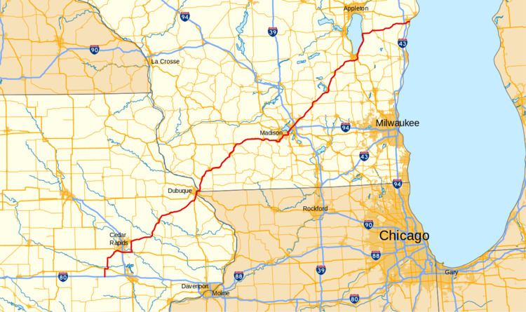
Map of US-151, United States
Approximately seven miles (11 km) south of Dubuque, Iowa, US 151 joins with US 61. The two highways share a route from there to Dickeyville, Wisconsin. Three miles (4.8 km) south of Dubuque, US 61 / US 151 join with US 52, and share a route with US 52 until the White Street exit in Dubuque.
In Wisconsin, US 61/151 joins with WIS 35 about one mile (1.6 km) north of the Iowa–Wisconsin border. At Dickeyville, US 151 splits off and heads northeast to Platteville. US 61 and WIS 35 continue north. US 151 later joins with US 18 near Dodgeville. The two highways share a route all the way to Madison.
Iowa
U.S. Highway 151 starts at an intersection with Interstate 80 (I-80), in an isolated part of Iowa near both Williamsburg and Conroy. It then continues through the area around the Amana Colonies, where it has a brief overlap with US 6. Once meeting up with US 30 and US 218, the route cuts around the city of Cedar Rapids, while the business route 151 goes through the city. The route splits from the other roads and continues toward Dubuque as an expressway. This 65-mile (105 km) stretch crosses many major rivers including both the Wapsipinicon and the Maquoketa. The road eventually goes into the Driftless Area where it meets up with US 61 around the Dubuque Regional Airport. The combined road then heads into the state of Wisconsin where it continues with the US 151 name.
Dubuque to Madison
US 151, concurrent with US 61, crosses the Mississippi River into Wisconsin via the Dubuque-Wisconsin Bridge from Dubuque, Iowa and passes through a cut in the river ridge before turning northward to the western terminus of WIS 11 after one mile (1.6 km) of due east travel. WIS 35 and the Great River Road join the route at that interchange, heading north. The highway at this point is limited access highway with two lanes in each direction. The northward trek of the route passes through mixed residential and farmland as it crosses Badger Road and merges with Eagle Point Road. Eagle Point road merges with US 151 from the left side of the road. The limited access portion ends at this interchange. Another pair of half diamond interchanges connect the highway with CTH HHH and CTH H as it bypasses Kieler to the northwest. At Dickeyville, US 61, WIS 35 and the Great River Road route exit north off of US 151 into town. US 151 passes Dickeyville to the east and descends into a valley cut northeast of the village, paralleling the Little Platte River and Blockhouse Creek within the valley for a one-mile (1.6 km) stretch before climbing back onto the ridgetop on the other side of the valley. US 151 then approaches Platteville and enters a section of limited access at CTH D (US 151 Business). The limited access stretch ends after three interchanges and 6-mile (9.7 km) to the east. The last of the interchanges being WIS 126/CTH G with access to Belmont. The route turns northeastward from this point, crosses the Cottage Inn Branch and begins the first of several descents into valleys, two of which are prior to passing Mineral Point and another two while passing the city.
The highway is limited access between the two interchanges that provide access to Mineral Point: CTH O and WIS 23. WIS 23 joins US 151 heading northbound at that point until the first interchange at Dodgeville. This interchange begins another short stretch of freeway to the point where US 18 joins the route. US 18 and US 151 head eastbound past that interchange.
The section of expressway past Dodgeville passes through rolling hills populated with farmland mixed with small woodlands. The highway passes Ridgeway and Barneveld. Access to Ridgeway is by surface intersections with a short "business route" on CTH HHH. However, it was announced in 2011 that the first intersection would be closed, and an exit would be constructed, due to the numerous fatal accidents that happen at the intersection each year. Access to Barneveld is at an interchange with CTH ID and an at-grade intersection with CTH K. CTH ID parallels US 18/US 151 for the entire stretch between Barneveld and Mount Horeb. A section of freeway begins at WIS 78 and ends at the other end of CTH ID as the highway bypasses Mount Horeb just to the south of the city's passing residential subdivisions. A mix of grade separation and level intersections cross the winding highway as it continues eastward until the interchange with CTH MV (Verona Ave) begins a section of freeway that bypasses Verona to the south. This section provides access to four interchanges including the two endpoints of CTH MV. The freeway ends and the route enters an urban multilane highway known as Verona Road as it passes through Fitchburg and into Madison. Verona Road passes through a commercial sector at CTH PD and past a residential area on the Southwest Side of Madison. US 18 and US 151 merge east on the West Beltline Highway — joining US 12 and US 14.
Madison metropolitan area
The four US Routes run concurrently for about three miles (4.8 km) to Park Street. At this interchange, US 14 turns south off the Beltline towards Oregon and US 151 turns north and into central Madison, US 151 passes Monona Bay to the west along South Park Street. US 151 turns northeast onto West Washington Ave for about 1500 feet, then follows Proudfit Street and North Shore Drive — paralleling the Monona Bay shore — and turns north onto John Nolen Drive. The street passes under the Monona Terrace Convention Center as it passes to the south and east of downtown Madison. US 151 turns northwest onto South Blair Street for three city blocks to East Washington Avenue — where it turns northeast and follows East Washington Avenue, bisecting the Madison Isthmus, and leading out of the city to the east. The left terminus of WIS 30 meets US 151 about three miles (4.8 km) northeast of the South Blair Street turn. and US 51 crosses US 151 one mile (1.6 km) further northeast.
Madison to Fond du Lac
At a cloverleaf interchange with I-39, I-90 and I-94, a section of freeway begins and continues along US 151 northeast through commercial zones into residential areas. The route bypasses Sun Prairie on the west and north sides through the city's residential zones. After Sun Prairie, US 151 passes through farmland, heading toward Columbus. The highway bypasses the city via a partial beltline to the north and east, completely clearing the city. WIS 16 and WIS 60 crosses under US 151 about midway along the Columbus bypass. US 151 becomes an expressway with level intersections after the interchange with WIS 73 at the end of the bypass portion. The route becomes a freeway at Beaver Dam, bypassing the city to the southeast. The route follows the edge of residential zones of the city before passing an industrial area at the northeast end of the bypass. Within this freeway section exists a level railroad crossing near CTH E (East Burnett Street). US 151 crosses at-grade intersections after the interchange with CTH A northeast of Beaver Dam and encounters one more freeway section at Waupun, bypasses the city to the east. The Waupun bypass also includes a level railroad crossing halfway between the CTH M and WIS 26 interchanges.The four-lane expressway of US 151 continues east, bypassing Fond du Lac to the south and east. This expressway provides a mixture of at-grade intersections and grade-separated interchanges at I-41 and WIS 23. WisDOT currently is studying upgrades to two sections of US 151. The first study would preserve the Fond du Lac Bypass from I-41 to WIS 23, with the ultimate goal being freeway conversion. The second study is examining freeway upgrades to the route from WIS 73 in Columbus to WIS 49 in Waupun.
Fond du Lac to Manitowoc
The multi-lane section of US 151 ends after turning north away from Fond du Lac and the route follows the east shore of Lake Winnebago for about half the length of the shoreline. US 151 then turns east at the intersection with WIS 55 and follows two-lane surface roads and briefly running concurrent with WIS 32 and WIS 57 in Chilton. The roadway passes through farmland throughout this section until it crosses over I-43 and enters Manitowoc. The route follows surface streets into Manitowoc and terminates in the downtown area at US 10 just blocks prior to the SS Badger carferry port.
History
US 151 was one of the original U.S. Highways from 1926. At the time, it only ran from Fond du Lac, Wisconsin to Madison. Originally, the highway ended at Western Avenue and Main Street in Madison. In 1934, the highway was extended southwest to Cedar Rapids, Iowa, incorporating the full length of former U.S. Highway 118 (Dodgeville to Dickeyville) and part of former U.S. Highway 161 (Dubuque to Cedar Rapids; US 161 from Cedar Rapids south to Keokuk became US 218). At the time, the southern end of the route was at Williams Blvd SW and 16th Ave SW, what was then US 30 and US 218. In the 1940s, the highway was extended northeast to Manitowoc.
Illinois
In 1969, the Eagle Point Bridge, which connected US 151 and US 61 with Wisconsin, was closed, and those highways were rerouted over the Julien Dubuque Bridge with U.S. Highway 20 from Dubuque to East Dubuque, Illinois. The route then followed Illinois Route 35 and WIS 35 north to what is now the current highway. In 1982, the Dubuque-Wisconsin Bridge opened, the old Eagle Point Bridge was demolished, and US 151 and US 61 were rerouted onto the new bridge. This is the only instance of US 61 and US 151 entering Illinois.
Routings
In 1981, the southern terminus of the highway was extended once again when the US 30 bypass was built. The southern terminus was at the US 151 and 30 interchange. By 1986, the main US 151 was rerouted onto state highway 13 and US 30 to bypass Cedar Rapids. The previous route through Cedar Rapids was renamed US 151 Business (though the official state designation for it is Iowa 922). Finally, in 1989, US 151 was extended to its current southern end at exit 225 along I-80. This extension followed the old route of Iowa 149. As a result, US 151 became the main route through the Amana Colonies.