
Formed July 10, 2015 Fatalities None | Dissipated July 26, 2015 Highest wind speed 167 km/h | |
 | ||
Highest winds 10-minute sustained: 150 km/h (90 mph)1-minute sustained: 155 km/h (100 mph) Lowest pressure 955 hPa (mbar); 28.2 inHg Damage $1.2 million (2015 USD) Date 10 July 2015 – 26 July 2015 Similar Typhoon Nangka, Typhoon Dolphin, Typhoon Noul, Typhoon Chan‑hom, Typhoon Goni | ||
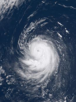
Tropical storm or typhoon halola goring 01c 2015
Typhoon Halola, known in the Philippines as Typhoon Goring, was a small but long-lived tropical cyclone in July 2015 that traversed the Pacific Ocean along a 7,640 km (4,750 mi) long path. Developing as the fifth named storm of the annual hurricane season south-southwest of Hawaii on July 11, Halola crossed the International Dateline late on July 12 and was recognized as the twelfth named storm of the annual typhoon season. It became a typhoon two days later. However, the system gradually decayed due to unfavorable conditions and weakened into a tropical depression on July 18. Halola strengthened into a tropical storm again on July 20 and became a typhoon again on the next day. It formed a short-lived eye, and it received the name Goring from the PAGASA on July 23. Halola weakened into a severe tropical storm over the Ryukyu Islands on July 25 and made landfall over Kyushu on the next day, shortly before dissipating in the Tsushima Strait.
Contents
- Tropical storm or typhoon halola goring 01c 2015
- Typhoon halola nhc cp01 jma 1512 pagasa goring jtwc 01c
- Meteorological history
- Wake Island
- Japan and South Korea
- References
The typhoon initially posed a significant threat to Wake Island, prompting the evacuation of all personnel; however, no damage resulted from its passage. Heavy rains and strong winds buffeted the Ryukyu Islands, with record rainfall observed in Tokunoshima. Damage was relatively limited, though the sugarcane crop sustained ¥154 million (US$1.2 million) in damage. One person was injured in Kyushu.
Typhoon halola nhc cp01 jma 1512 pagasa goring jtwc 01c
Meteorological history
Late on July 6, a tropical disturbance formed about 1,840 km (1,145 mi) southwest of Honolulu, Hawaii. During July 10, the CPHC reported that atmospheric convection around the disturbance had persisted for long enough for the system to be considered a tropical cyclone. As a result, they initiated advisories on Tropical Depression One-C and estimated that the system had 1-minute sustained wind speeds of 30 mph (50 km/h). Over the next day the system gradually intensified and organised further as it moved westwards, before it was named Halola by the CPHC during July 11, after it had intensified into a tropical storm. The system continued to move westwards and slowly intensify over the next couple of days and moved out of the Central Pacific basin and into the Western Pacific as it crossed the International Dateline on July 12. Within its first advisory on the system the Japan Meteorological Agency (JMA) reported that the system was a severe tropical storm. With good dual outflow channels, both the JMA and the Joint Typhoon Warning Center upgraded Halola to a typhoon on July 14, with a small but brief eye. Although the JMA claimed that Halola strengthened a little later, the JTWC analyzed that it had struggled to intensify and begin to weaken.
Because of high vertical wind shear, Halola became very disorganized near Wake Island on July 16 with convection sheared to the east side of its ragged low-level circulation center. As the result, the JMA downgraded the system to a tropical storm, so did the JTWC. On July 18, with significant dry air from a TUTT cell to the north, Halola further weakened into a tropical depression, as only elongated and exposed low-level cloud lines wrapped into an ill-defined center. Two days later, with improved poleward and equatorward outflow, Halola re-intensified into a tropical storm and continued tracking west-northwestward along a deep-layered subtropical ridge early on July 20, revealing a more symmetric and deeper moisture signature. Moreover, it then took only six hours to intensify into a severe tropical storm, according to the JMA.
Under warm sea surface temperature, low vertical wind shear and excellent diffluence aloft, Halola intensified into a typhoon again in the area between the Northern Mariana Islands and the Volcano Islands early on July 21, forming a significant but cloud-filled eye briefly; besides, the JMA analyzed that the typhoon had reached peak intensity at noon, with ten-minute maximum sustained winds at 150 km/h (90 mph) and central pressure at 955 hPa (28.20 inHg). Halola tried to form an eye again but filled quickly early on July 22, before the JTWC analysed that the typhoon had reached peak intensity at 18:00 UTC, with one-minute maximum sustained winds at 165 km/h (105 mph). A well-defined eye appeared again but maintained briefly early on July 23, shortly before the PAGASA named the typhoon Goring. After that, dry air began to wrap around the core, resulting in a weakening convective structure.
Failing to form a stable eye again, the typhoon started to weaken more on July 24, as dry air and northeasterly moderate vertical wind shear were together eroding the system. Late on July 25, Halola passed near the Japanese islands of Amami Ōshima. On July 26, Halola made the first landfall over Saikai, Nagasaki at around 09:30 UTC and the second landfall over Sasebo, Nagasaki at 10:00 UTC. Six hours after Halola's second landfall, Halola was declared dissipated.
Wake Island
Typhoon Halola was the first significant threat to Wake Island since Hurricane Ioke in 2006, which caused tremendous damage and forced the closure of the island for three months. The Tropical Cyclone Condition of Readiness (TCCOR) level was raised to 3—indicating winds of 93 km/h (58 mph) or higher are possible within 48 hours—by 2:00 p.m. local time on July 14. That day, a Boeing C-17 Globemaster III aircraft from the Hawaii Air National Guard was used to evacuate 125 Department of Defense personnel deployed on Wake Island due to the threat of storm surge. The evacuees were brought to Anderson Air Force Base on Guam. The TCCOR was raised to level 2—indicating winds of 93 km/h (58 mph) or higher are expected within 48 hours—on July 15. Warnings were discontinued as the storm weakened and moved away from the island the following day.
Members of the 36th Contingency Response Group and the 353d Special Operations Group were parachuted onto the island on July 18 to conduct damage assessments and clear the airfield of debris. Little, if any, damage was incurred according to their assessments. The airfield was re-opened on July 20 and personnel resumed normal operations.
Japan and South Korea
On July 22, Sasebo Naval Base was placed on alert for possible effects from the approaching typhoon. TCCOR 3 was raised for all United States military bases in Okinawa the next morning. This was subsequently extended on July 24 to cover Sasebo and Marine Corps Air Station Iwakuni while the bases on Okinawa were placed under TCCOR 2. Additionally, TCCOR 4—indicating winds of 93 km/h (58 mph) are possible within 72 hours—was raised for Camp Walker and Chinhae Naval Base in South Korea. During the evening of July 24, TCCOR 1—indicating winds of 93 km/h (58 mph) are expected within 12 hours—was issued for the Okinawa bases. Sasebo Naval Base entered TCCOR 1 late on July 25. Following the storm's degradation into a depression on July 26, all TCCOR levels were dropped or reduced. More than 100 flights to and from Naha Airport were cancelled, affecting approximately 16,000 passengers, with All Nippon Airways comprising the majority of affected flights. Eight flights to and from Kumejima were also canceled. The JMA warned residents across Kyushu to be on alert for flooding.
Owing to the typhoon's northward turn, Okinawa was largely spared noticeable impact. Sustained winds at Kadena Air Base reached 48 km/h (30 mph) with gusts reaching 69 km/h (43 mph). East of Okinawa in the Daitō Islands, sustained winds reached 114 km/h (71 mph) on Minamidaitōjima with a gust of 157 km/h (98 mph); both values were the highest in relation to the storm on land. Similar winds were recorded on Amami Ōshima, situated between Okinawa and Kyushu. Torrential rains affected portions of the archipelago, with Isen, Tokunoshima, recording record-breaking accumulations. Twenty-four-hour totals reached 444 mm (17.5 in), including 114.5 mm (4.51 in) in one hour and 258.5 mm (10.18 in) in three hours; all three values were record amounts since the station began observations in 1977 and considered a 1-in-50 year event. Rainfall reached 109 mm (4.3 in) on Okinoerabujima. Ironically, Halola helped suppress rainfall across the majority of mainland Japan by severing a plume of moisture previously bringing several days of heavy rain. Most areas across western Japan received modest rainfall from the dissipating storm.
Throughout the Daitō Islands, sugarcane farms were significantly affected by Typhoon Halola, resulting in ¥154 million (US$1.2 million) in damage. The heavy rains on Tokunoshima prompted the evacuation of 7,500 residents and flooding damaged 90 homes. Multiple landslides were reported on the island. Power outages took place on Kitadaitōjima and Minamidaitō. A landslide in Kunigami forced the closure of National Route 331. In mainland Japan, one person was injured in Kumamoto Prefecture, Kyushu, after falling from a roof. In Akita Prefecture, Honshu, river levees were breached by heavy rain brought on by the combination of a weather front and the remnants of Halola.