
Established 1 April 1908 Local time Sunday 10:11 AM | Area 194.8 km² Population 4,908 (2015) | |
 | ||
Weather 19°C, Wind W at 11 km/h, 91% Humidity Points of interest Cape Hedo, Okuma Beach, Dai Sekirinzan Park, Hiji Falls, Kayauchi Banta | ||
Kunigami (国頭村, Kunigami-son, Kunigami: Kunzan, Okinawan: Kunjan) is a village in Kunigami District, Okinawa Prefecture, Japan. It occupies the north tip of Okinawa Island, with the East China Sea to the west, Pacific Ocean to the east, and villages of Higashi and Ōgimi to the south.
Contents
- Map of Kunigami Kunigami District Okinawa Prefecture Japan
- History
- Geography
- Neighbouring municipalities
- References
Map of Kunigami, Kunigami District, Okinawa Prefecture, Japan
As of 2015, the village has a population of 4,908 and a population density of 25.20 persons per km2. The total area is 194.80 km2.
History
According to Chūzan Seikan, the goddess Amamikyo consecrated the first utaki in Asa Forest at Hedo, in what is now Kunigami; the forest is also mentioned in Omoro Sōshi. Ceramics from the Jōmon-period Uzahama Site (宇佐浜遺跡) resemble those found in the Amami Islands. Chūzan Seikan records the prayers of the Kunigami council for the recovery of Shō Sei after an abortive attempt to occupy Amami Ōshima in 1537, while Kyūyō recounts the appointment of the son of the Kunigami Oyakata as aji after the successful takeover of the Amami Islands by Shō Gen in 1571.
Kunigami District was established in 1896 and, upon the abolition of Kunigami magiri, Kunigami Village was founded in 1908. During the Battle of Okinawa, the area saw an influx of refugees fleeing the heavy fighting in the south. In September 1945, the occupying government merged the three villages of Kunigami, Higashi, and Ōgimi into the new city of Hentona (辺土名市); the merger was reversed the following year.
Geography
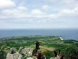
Kunigami is mountainous, with over 80% of the land area covered by subtropical evergreen forest. Endemic species include the Okinawa woodpecker and Okinawa rail.