
 | ||
Edinburgh constitutes a major transport hub in east central Scotland and as such is at the centre of a multi-modal transport network comprising road, rail and air communications connecting the city with the rest of Scotland, the United Kingdom and internationally.
Contents
- Airport
- Bus services
- Bus corridors
- Edinburgh Waverley
- History
- Other stations and services
- Trams
- Road network
- Traffic congestion
- Park and ride
- Edinburgh Congestion Charge
- Improvements to public transport
- Cycling
- Thefts
- Safety
- Disputes
- Waterways
- Pedestrians
- Plans
- Edinburgh Airport Rail Link EARL
- Forth hovercraft
- High speed rail
- References
Transport is an area under the control of the Scottish Parliament and Scottish Government who have the statutory ability to control, fund and regulate transport projects of national importance within the city. Transport for Edinburgh is the City of Edinburgh Council's executive body responsible for the development of all transport projects within the city and brings a number of key transport providers together under the one umbrella.
Public transport in Edinburgh is generally extensive and efficient, but problems such as traffic congestion and the delivery of key transport projects in the city are a prevailing concern.
Airport
Edinburgh's International Airport (Turnhouse) is located 8 miles to the west of the city centre, on the A8 trunk road, and is the principal international gateway to the city, as well as the busiest airport in Scotland. It is owned and operated by Global Infrastructure Partners. The airport serves a wide range of domestic and an expanding number of European, transatlantic and Middle East destinations, handling around 11 million passengers per year. In 1991 over 2m passengers used the airport - this represents an annual increase in excess of 10%. Forecasts suggest that the number of passengers using the airport will further increase to nearer 26 million by 2030.
The main terminal building was built in 1977 by the Edinburgh architect Robert Matthew, and was substantially extended and modernised in the late 1990s. A £14m project to construct a new international pier, further increasing capacity, was completed in 2006.
A masterplan for the growth of the airport was published in May 2005 indicating that the main terminal building will need to be increased in size, new aircraft hangars, maintenance facilities, and cargo handling facilities will need to be constructed. The possibility of a second runway built on land to the north of the current airfield, has been mooted, to cope with the forecast growth in air traffic. A new air traffic control tower was opened in October 2005.
Currently the airport is connected to the city centre by a dedicated bus link operating from the main terminal building to Waverley Bridge and a new tram link from the airport to the city centre which opened in May 2014
Bus services
Bus transportation is the principal means of public transport in Edinburgh, with an extensive bus network, covering all parts of the city, its suburbs and the surrounding city-region. Edinburgh is widely regarded as having one of the most extensive bus services in the country, with some of the highest patronage figures in the UK outside of London. The number of bus trips taken by Edinburgh residents in any one year is 188, more than double the national average, with a growth rate of 27% over the period 1998 to 2005, representing an annual increase of around 4%
There are two major bus operators in Edinburgh:
Lothian Regional Transport was the precursor to Lothian Buses and was formed in 1986 after bus services were de-regulated by the Transport Act 1985. Lothian Regional Transport changed its title to Lothian Buses in 2000. It is a publicly owned company with Edinburgh City Council having the 91% controlling stake in the company with the remainder divided between the local authorities of Midlothian, East Lothian and West Lothian. Lothian Buses also run the Airport Express shuttle between Edinburgh Airport and the city centre, as well as a network of night buses operating on popular routes between midnight and 5am.
Both First Scotland East and Lothian Buses charge a single flat fare regardless of distance, and operate a day ticket system, allowing unlimited travel on their buses during the day. Most buses run at intervals of between 10 and 30 minutes during the day and a reduced service after 7pm.
As well as local services within the city, several companies offer inter city services between Edinburgh and various other cities within Scotland and the UK. Scottish Citylink offer services from Edinburgh to places such as Stirling, Perth and Glasgow, and Megabus operates budget services between Edinburgh and Glasgow and London.
Edinburgh Bus Station is located on St Andrew Square in the city, but is not used by local services.
Bus corridors
From December 2004 to January 2008, a 1.5 km long guided busway - "Fastlink" - ran between the west Edinburgh suburbs of Stenhouse and South Gyle, parallel to the railway line from Haymarket to South Gyle. There were four passenger halts on the busway at Broomhouse East, Broomhouse West and Saughton East and West. Edinburgh Trams, from the city centre to the Airport, now run on the corridor previously occupied by the Fastlink guideway with stops at Saughton, Bankhead and Edinburgh Park Station.
Priority bus lanes on arterial routes into Edinburgh city centre, known as Greenways, because of the distinctive green tarmac used to surface them - were introduced in 1997. Currently the main Greenways into the city are on the following routes:
A Traffic Regulation order bans general traffic from using these priority lanes during the day, restricting use to buses, Taxis and bicycles. Red lines at the side of the road prohibit parking and stopping on Greenways as a measure to reduce the congestion faced by normal bus lanes caused by on-street parking. Most Greenways are operational between 07.30 and 09.30 and 16.00 to 18.30 Monday to Friday and 08.30 to 18.30 on Saturdays. There are exceptions to this e.g. on Glasgow Road the Greenway is not operational at all on a Saturday and Sunday. On the main route into Edinburgh city centre from the west - the A8 - 55% of the 6.7 km route is inbound bus lane, whilst 54% is outbound bus lane. Lothian Buses and First Scotland East are the main providers of bus services using the greenways scheme, with services every 12 minutes.
Edinburgh Waverley
Edinburgh Waverley is the main Network Rail station serving the city. Located in a ravine the heart of the city centre close to Princes Street Gardens, it serves over 14 million passenger journeys per year. It is a principal station on the East Coast Main Line between London and Aberdeen, and is the terminus as well as start point for many rail services within Scotland. Virgin Trains East Coast serves the main Edinburgh to London route. Abellio ScotRail are the operating company for many routes within Scotland. TransPennine Express, Virgin Trains and CrossCountry provide the remaining services to long distance destinations via the West Coast Main Line.
Trains leave Waverley in two directions:
History
Edinburgh at one stage had a well-developed rail network. Starting with the Edinburgh and Dalkeith Railway, whose terminus was at St Leonards on the east of the Old Town, and the Edinburgh, Leith and Newhaven Railway (later the Edinburgh, Leith and Granton Railway), whose terminus was at Canal Street (on the site of today's Waverley Station). The Edinburgh and Glasgow Railway opened in 1842. By the mid-20th century competition between the North British Railway and the Caledonian Railway, together with the conservatism of the city's local government, combined to make the network very inefficient, with much duplication of routes. Most stations closed down and, following the Beeching Axe in the late 1960s, the city was left with only three passenger railway stations (Waverley, Haymarket & Slateford). The South Suburban line was left in place, mainly as a bypass for freight services to avoid the city centre. New stations have been opened on the existing lines at Brunstane, Newcraighall, South Gyle and Edinburgh Park in recent years. The city currently has 12 stations within the City of Edinburgh Council area.
Edinburgh Gateway, serves as an interchange with Edinburgh Trams in Gogar to provide a link to Edinburgh Airport. The station opened on 11 December 2016.
Other stations and services
Edinburgh itself has a small suburban rail network - the backbone of which is the Edinburgh Crossrail - which commenced operations in 2002, running in an east-west axis across the city, linking the stations of Edinburgh Park, in the west with Haymarket, Waverley (in the city centre) and Brunstane and Newcraighall, to the east. The other stations in the city are South Gyle, Dalmeny (for South Queensferry), Slateford, Kingsknowe, Wester Hailes and Curriehill.
Haymarket railway station is the second major station in Edinburgh and is located in the heart of the west end of the city, which is an area of many offices and businesses, and is thus a popular station with commuters and busy at peak periods. The complete re-development of Haymarket is currently underway, partly in response to the needs of the station to improve access for disabled passengers. A new concourse and access bridge is being constructed to the west of the existing bridge, which will feature better facilities and step-free access to all platforms
Both stations are served by trains travelling onward to other destinations in Scotland from Edinburgh Waverley, operated by Abellio ScotRail:
Trams
The Edinburgh Trams is a new tram line which opened on 31 May 2014, connecting the airport on the western edge of the city, with Haymarket, Princes Street, St Andrew Square and York Place in the city centre. A further extension to the redeveloped waterfront areas of Leith, Granton and Western Harbour has been postponed due to costs.
The planning, design and construction of the tram network was originally overseen by the City of Edinburgh Council's wholly owned company Transport initiatives edinburgh (tie). The Scottish Parliament gave legislative consent to the parliamentary bills, required for the project to commence, in March 2006. Construction of the network was originally scheduled to start in spring 2007, beginning with the repositioning of the network of gas and water mains that lie under the proposed routes. Work finally started in July 2007.
The estimated cost of the scheme had been anticipated to be in the region of £592m, with a contribution of £450m-£500m from the Scottish Executive and £45m from City of Edinburgh Council. Cost increases, plus interest payments on loans, are now (as of 2011) likely to see the eventual expenditure reach £1bn.
In 2006, there was a controversy about the construction of the tram network, with worries over escalating costs and disruptions due to construction. Following a vote in the Scottish Parliament on 27 June 2007, it was agreed to continue with the tram project - despite the opposition of the SNP minority government.
Road network
The Edinburgh City Bypass (A720) skirts the southern fringes of the city. The road was constructed between 1981 and 1990 and opened to motorists in sections. The road is one of the main trunk roads in east central Scotland linking vitally important routes such as the M8, the main route west to Glasgow, the A1, one of the two primary routes south from Scotland to England, and the M9 to Stirling. The City Bypass is linked by the A902 to the A90 leading north out of the city.
Edinburgh itself is the hub of the A-road numbering system within Scotland, and many radial routes lead in and out of the city. Routes radiating from Edinburgh are as follows (in a clockwise direction):
Construction on the Forth Replacement Crossing, adjacent to the Forth Road Bridge, began in 2011, and the new route is due to open in 2016. In order to alleviate traffic congestion in many areas, park and ride facilities have been provided at several points on the periphery of the city.
Traffic congestion
Like many cities, traffic congestion is a significant problem in and around Edinburgh, with 160,000 vehicles entering the city every day which is forecast to rise to 180,000 by 2016. This is especially problematic in the rush hour periods from 7.30am to 9.30am and 4pm to 6pm. Increasing levels of traffic congestion in Edinburgh are generally attributed to the city's strong population growth as well as an expanding economy. Areas in the future which are expected to suffer acutely from traffic congestion in Edinburgh include the western outskirts of the city, the waterfront, and the residential areas of the South East where there is a large amount of housing development. Notorious traffic hotspots in Edinburgh include the Straiton and Dreghorn junctions on the Edinburgh City Bypass. The Newbridge Roundabout on the A8 western approach to the city and the Gogar Roundabout close to Edinburgh Park are other bottlenecks in the west of the city which suffer from congestion. The office and business developments at Edinburgh Park themselves generate a large amount of traffic in that part of the city, with the new Royal Bank of Scotland headquarters opening at Gogarburn ensuring that upwards of 20,000 people now work in this area. In the city centre itself, narrow, cobbled and winding streets in the Old Town as well as increasing restrictions on vehicles entering the city and strict parking regulations mean that traffic hotspots are common in the city centre itself. Queen Street, Charlotte Square and the western end of Princes Street are areas of significant traffic delay.
Park and ride
Park and ride facilities have been provided on the outskirts of the city, such as at Ingliston near Newbridge in the west of Edinburgh with spaces for 535 cars, as well as at Hermiston on the Edinburgh City Bypass, Newcraighall in the east of the city and at Ferrytoll in Fife. The schemes consist of large surface car parks off the main roads into the city where buses take passengers from these peripheral facilities into the city centre via a number dedicated stops, thus cutting down on the number of cars making the journey into the congested city centre. The Park and Ride schemes at Hermiston and Ingliston have been widely regarded as successful, with each attracting more than 500 motorists per day, preventing more than 50,000 car journeys into the city.
Edinburgh Congestion Charge
Following on from the implementation of the London congestion charge in February 2003, City of Edinburgh Council announced plans to introduce a road tolls scheme to be put in place on main routes into the city. A postal referendum of Edinburgh residents was held between 7–21 February 2005, with 74.4% of those voting no, announced on 22 February 2005. The system would have operated in a broadly similar fashion to the one in London, with two cordons - an inner cordon and an outer cordon operating from Monday to Friday. A flat charge of £2 would have applied to vehicles entering the city boundary - by passing the outer cordon, or those entering the city centre by passing the inner cordon. This charge would have applied no matter how many times a vehicle crossed both cordons. Cameras with automatic number plate recognition technology would have been placed at the entry to both cordons, which would record the registration numbers of vehicles passing them. At the end of each day numbers would have been recorded against received payments. Paying would have been done electronically via the internet, text message or at specialised payment terminals in shops, where daily, weekly, monthly and yearly passes would have been available.
The proposal faced strong opposition from city centre retailers who were concerned about the impact it would have on their trade as well as a number of political parties. Following the no vote, the City council abandoned plans to introduce road tolls in Edinburgh.
Improvements to public transport
In an attempt to discourage car use and increase patronage of public transport - Transport for Edinburgh, the integrated transport delivery authority of City of Edinburgh Council, has embarked upon an extensive drive to improve public transport in the city. These include new railway stations, improvements to roads, pavements and footways, easier ticketing arrangements on buses, new bus shelters, pedestrian crossings and refuges, easy access buses, car parking payment by mobile phone and a real time bus tracker service in place at many bus stops and bus interchanges in the city. Recently the city has seen the introduction of the Edinburgh trams, major improvements to Edinburgh Waverley including new platforms to cope with new routes and increased passenger numbers, a £25 million redevelopment of Haymarket railway station, as well as new railway lines opening to Airdrie and Bathgate, and from 2015 to Tweedbank in the Scottish Borders.
Cycling
Since 1999 the percentage of all trips in the city of Edinburgh made by bicycle has risen by an eighth, however travelling by bicycle still accounts for less than 2% of all trips taken by Edinburgh residents, with bicycle use lower than in many other European cities such as Amsterdam or Paris. Like most cities cycling is seen as a clean, environmentally friendly method of transportation, which needs little space, the provision of few, inexpensive facilities as well as a means of attempting to cut down on traffic congestion.
At present there are around 75 km of off-road cycleways in the Edinburgh area, with a similar length on on-road cycleways in the city. Greenways, which are the car-free bus corridors on the main radial routes into the city centre double up as cycle lanes.
Many improvements in facilities for cyclists in Edinburgh can be attributed to Spokes, the Lothian Cycle Campaign, formed in 1977. Attempts to make Edinburgh more "cycle friendly" have been made, particularly by Spokes. Some cyclists remain unconvinced that the promise of a "Model Cycle-Friendly City" has been achieved.
Thefts
Cycle thefts are common in the city, with an average of five bikes being stolen every day. Ian Maxwell, a member of Spokes Lothian Cycle Campaign, said: "We've seen a massive increase in cycling in Edinburgh over the last ten years and, unfortunately, with that trend comes an inevitable rise in thefts. Overall, though, with tens of thousands of cyclists, the numbers are still relatively low. The figures underline the problem of lack of secure parking facilities for bikes. They can be difficult to find. Cyclists need to take the appropriate precautions. These are opportunist thieves who move quickly and disappear on their newly acquired getaway vehicle."
Safety
Lothian's roads are the most dangerous in Scotland for cyclists, with 165 cyclists a year being hospitalised. Problems are reported for cyclists riding in bus lanes in central Edinburgh, such as Princes Street and Lothian Road. A number of cyclists have been killed in Edinburgh in recent years; in September 2004, a 28-year-old man was killed at the junction of Marchmont Road and Melville Drive. In April 2008, an award winning neuroscientist who worked at the University of Edinburgh, Dr Iain Wilson, was killed in a collision with a truck on the junction between West Richmond Street and Nicolson Street.
Disputes
Pedicabs are a common form of transport for weekend revellers, with the number operating in Edinburgh growing from only 2 in 2000 to 60 by 2008. This has led to a growing number of complaints from taxi cab drivers, who resent the competition. In one dispute, a pedicab cyclist was reported to have been attacked by a group of three taxi drivers, who kicked and headbutted him. In other cases, taxi drivers have thrown cigarette butts at pedicab cyclists, and in one case, threatened a cyclist with a Taser stun gun (possession of such a device is illegal in Scotland).
Cycling in certain public parks, like walkways across the Meadows, has been legal since the passage of the Land Reform Act in 2003, although signage was not corrected until 2011 in some cases. Portobello promenade has likewise been officially acknowledged as a legal cycle route. Concerns have been expressed that cyclists may run pedestrians over. Peng Lee Yap, chairman of Friends of the Meadows, said "While this is clearly a difficult issue, it was felt that the positive way forward is the approach of Spokes to improve cyclists' behaviour." In late 2007 Spokes Lothian group launched their "Bike Polite" campaign to encourage cyclists to be more considerate.
Waterways
The Union Canal was opened in 1822 and provides an inland waterway link from Edinburgh to Falkirk and from there to Glasgow via the Forth and Clyde Canal. It is currently owned by the public corporation Scottish Canals and chiefly used for leisure purposes.
Pedestrians
Given that Edinburgh is a small, relatively walkable city, travelling by foot is a possible means of transport for the majority of citizens who live, work or visit the city. Like most urban zones pedestrian density is at its highest in the commercial core of the city, where there the majority of shops, businesses and offices are located, with pedestrian density tailing off rapidly through the inner city, to the suburbs. In Edinburgh, pedestrian density is at its highest around Princes Street, George Street, Rose Street, the Royal Mile, the North and South Bridges as well as George IV Bridge. These are the areas where the majority of city centre shops have their premises, as well as bars, restaurants and pubs, as well as tourist attractions such as the Scott Monument, Edinburgh Castle and the Holyrood Palace are situated.
Unlike Glasgow most of the city centre is not pedestrianised, with the exception of Rose Street (parallel to Princes Street), which is pedestrianised along its length. A section of the Royal Mile - one of the main tourist streets in Edinburgh - from the junction of George IV Bridge (Melbourne Place) to the junction with North Bridge, is pedestrianised through the use of automatic bollards which only give access to authorised vehicles. This is an area with pavement cafes and bars with tables outside.
Plans
Following elections to the Scottish Parliament in May 2007, the Scottish National Party formed a new minority government. As of June 2007, both the tram project and rail link to Edinburgh Airport (described below) were scrutinised by the Scottish Executive with a view to possible cancellation, largely on grounds of cost. The Auditor General for Scotland was asked to consider the issue of value for money and gave a favourable response for the tram project.
Edinburgh Airport Rail Link (EARL)
There is currently no rail link to Edinburgh Airport, with the nearest railway stations being at Edinburgh Park and South Gyle, some distance from the airport.
The former Labour and Liberal Democrat coalition administration in Scotland (1999–2007) proposed a rail link, with plans for completion by 2010. Such a link was viewed as necessary because of the growth of road traffic in the immediate vicinity of the airport, meaning the existing road network in the area is operating at maximum capacity or nearing capacity. Furthermore, in comparison to other BAA plc airports in the UK a relatively low proportion of Edinburgh Airport passengers use public transport (19%) with most journeys being by private car (49%). The rail link would have been connected to the main Edinburgh – Glasgow line by a new railway line via Winchburgh and Edinburgh Park station. A second link would have joined the Fife lines to this route prior to reaching the airport station. The rail link would also pass under the runway and split westward near Kirkliston towards Glasgow and Stirling and eastward to Fife and the North, and would require the construction of a new subsurface railway station in front of the terminal building. A parliamentary bill was submitted to the Scottish Parliament which needed to be considered and approved before construction could take place. The Bill received Royal Assent on 19 April 2007. Initial estimates suggested that the scheme would have cost around £500m.
In 2007, the SNP minority administration planned to scrap EARL as a manifesto commitment. Following a vote in the Scottish Parliament on 27 June 2007, the EARL project was effectively cancelled in its original form, however plans to build an overground station at Gogar with direct rail access from the Fife line are being progressed.
Forth hovercraft
Proposals were put forward by Fife Council in 2004 for a passenger ferry service to operate between Kirkcaldy and Leith. The plans envisaged a half-hourly service across the Firth of Forth, operational by 2008, with two vessels capable of carrying up to 150 passengers.
An experimental hovercraft service ran in summer 2007 between Kirkcaldy and Seafield, operated by Stagecoach Group. Journey times were 18 minutes and the service was used by around 32,000 passengers.
Cross-Forth proposals were revived in 2009 when Edinburgh Council began to examine the possibility of beginning either a ferry service between Burntisland and Granton, or the revival of the hovercraft service. In January 2010, Stagecoach set up a joint venture with hovercraft makers the Bland Group to run a hovercraft service, and secured funding of around £14 million. Subject to funding Edinburgh and Fife councils, the companies hope to construct a dedicated hovercraft terminal near the promenade at Portobello and begin passenger operation by 2012. They estimate 870,000 people would use the hovercraft service each year, and sailings would connect with local bus services into Edinburgh and around Fife. As of 2014, the planned hovercraft service has not materialised.
High-speed rail
Community and business leaders in Edinburgh have voiced support for the construction of a high-speed rail link between Glasgow and Edinburgh to reduce current journey times between Scotland's two main cities. Currently First ScotRail operate a shuttle service, every 15 minutes between 7am and 7pm, between the two cities on the Glasgow to Edinburgh (via Falkirk High) line, with journeys taking around 50 minutes. It is estimated that a high-speed maglev system would halve the journey time between the two cities. The UK Government has also conducted a feasibility study into ascertaining whether a high-speed Maglev network between Edinburgh and London would be economically beneficial and thus cutting down on the growth of domestic air traffic between the two cities. Such a system would, however require a complete new infrastructure as it is not compatible with the existing rail infrastructure.
History
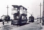
Edinburgh formerly had an extensive municipally owned tram system. Edinburgh Corporation Tramways were cabled-hauled until the early 1920s, then converted to electric traction. The last tram on Edinburgh's original system operated in 1956.