
Dates of operation 1892–1894 | Headquarters Toronto, Canada | |
 | ||
Track gauge 4 ft 8 ⁄2 in (1,435 mm) standard gauge | ||
The Toronto Belt Line Railway was built in Toronto, Ontario, Canada in the 1890s. It consisted of two commuter railway lines to promote and service new suburban neighbourhoods outside of the then city limits. Both lines were laid as loops. The longer Don Loop running north of the city limits, and the shorter Humber Loop ran west of the city limits. The railway was never profitable and it only ran for two years. Today, as part of a rails-to-trail project, the Beltline Trail lies on the right-of-way of the Don Loop.
Contents
Routes
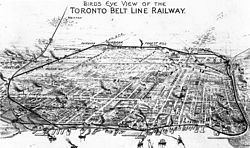
The railway consisted of two separate loops both starting and ending at Union Station.
The larger Don loop went east on the tracks of the Grand Trunk Railway via The Esplanade to the Don River. It then turned north following the river passing the Don Valley Brick Works on its west side before journeying up a steep grade through the Moore Park Ravine (called "Spring Valley" in Belt Line brochures). It then turned west at the north edge of the Mount Pleasant Cemetery along Merton St. At Yonge Street it turned northwest travelling through Forest Hill until just north of Eglinton Avenue West. There, it turned west again before returning to Union Station via the Grand Trunk Railway (today's Barrie line) line west of Caledonia Road. A complete trip around the Don Loop was approximately 27 km (17 mi).
A second, smaller Humber loop headed west along the northwest rail corridor of the Grand Trunk Railway through Parkdale. It turned west just north of St. Clair Avenue and then turned south at Lambton Mills, just east of the Humber River. It ran south following the edge of the Humber River valley. It followed a route paralleled by the South Kingsway just west of High Park. It returned east along Lake Ontario via the tracks of the Toronto, Hamilton and Buffalo Railway. A complete trip around the Humber Loop from and returning to Union Station was approximately 24 km (15 mi).
According to Lyman B. Jackes, there was a spur line north of St. Clair Avenue to link the two loops so that Belt Line trains could operate from one loop to the other. However, according to R.L.Kennedy, such a connection was proposed but never built.
History
Entrepreneur James David Edgar lead a group of investors to develop suburban land and build a railway to service these proposed suburban residential developments. The company would promote properties in Moore Park, Forest Hill, Fairbank and Fairbank Junction, areas along the Belt Line.
As a result of a booming real estate market in the late 1880s, two related companies were founded. The Toronto Belt Land Corporation was incorporated on July 16, 1889 to subdivide and sell land in the new suburbs, and the Toronto Belt Line Railway Company was founded on March 23, 1889 to build a commuter railway to connect these new suburban areas to the city. A pamphlet by the Toronto Belt Land Corporation described the railway's mission as: "to economize time by rapid transit, and to carry men, women and children with comfort, safety and speed beyond the cramped and crowded city to the airy uplands; whence having enjoyed the rest and refreshment of commodious homes and spacious grounds, they can return on the morrow to renew, with quickened energies, the task of life." The railway was to support a suburban lifestyle.
The cost of railway construction was $462,000, much higher than investors had expected. There were also lawsuits over land acquisitions and difficult negotiations with the City over access through the Don Valley. The real estate boom busted before the railway could be completed resulting in bankruptcy for the company. The Belt Line was then taken over by the Grand Trunk Railway.
By 1881, 90 workers were building the Don Loop east of Yonge Street, and 140 workers to the west.
Passenger service first began on July 30, 1892, under the full control of the Grand Trunk Railway. Six trains per day (reduced to three per day in July 1894) were operated in both directions on each of the two loops. The heaviest usage was excursion travel on Sundays. The line used five 4-4-2 tank steam locomotives built at the GTR's Point St. Charles shops. According to an August 1892 article in the Toronto Mail, the passenger coaches resembled an improved version of those used on the New York elevated railway at that time.
The railway ceased on November 17, 1894 after 870 days of passenger service. The railway never made a profit. There were a number of reasons for this - the fare prices were too high at the time (5 cents per station to a maximum fare of 25 cents), there was insufficient population and ridership, and the country was experiencing a financial depression in the 1890s. The success of the enterprise depended on the rapid development of suburban properties, and a monopoly of transportation service to the developing areas. The drive to develop these new communities was blunted by the depression of 1893, and it took longer to open up the new neighbourhoods than the developers had hoped. Also, electric streetcars of the Toronto Railway Company along with radial railways such as the Metropolitan Street Railway were providing more direct routes to downtown.
Shortly after passenger trains stopped operating, parts of the Don Loop sat unused for several years.
In 1906, the relatively short section in the Don Valley south of Winchester St. (across from Riverdale Park) was used as part of a new line by the Canadian Northern Railway connecting Toronto to Parry Sound.
In 1910, the Grand Trunk Railway rebuilt the portion of the Don Loop between Fairbank Junction and Mount Pleasant Road for freight service. This was to support the delivery of fuel and building supplies by rail for use in residential areas neighbouring the eastern end of the spur.
The tracks on the steep grade (4%) in the Moore Park Ravine were pulled up during World War I due to a shortage of iron.
A 1921 engineering report said that few sections of the Humber Loop had good track in place. Wooden bridges had deteriorated. Adjacent home-owners had extended their back yards onto the right-of-way. There were municipal seizures due to defaulting on tax payments.
The Grand Trunk Railway went bankrupt in 1923 and became part of Canadian National Railways. The Belt Line was eventually sold on December 31, 1943 to Canadian National Railway (CNR) for $410,000 CAD. Three of the five 4-4-2T commuter tank locomotives specially built for the Belt Line were eventually used on the Thousand Islands Railway in Gananoque, Ontario.
Part of the right-of-way of the Humber Loop was used by the Toronto Suburban Railway between 1925 and 1931. Canadian National Railway used part of the Humber Loop, which became the Lambton Spur, to service local industries until about 1960-1970, with the final segment from Weston Road to Symes Road closing on February 26, 1980.
In the 1950s the TTC subway yard at Davisville opened at Yonge St. The Belt Line spur was used to deliver new subway cars on flat cars to the upper Davisville Yard until the Greenwood Yard opened in 1965.
The service east of Yonge Street bridge was terminated in the 1960s when that bridge was closed. The last commercial organization to use the spur east of Yonge Street was Dominion Coal whose coal silos were built in 1928. The switch connecting the spur to the unloading siding was removed when the Mount Pleasant bridge over the Belt Line was rebuilt in 1976. The silos were demolished in 2001.
Part of the right-of-way of the Don Loop was expropriated to build the Spadina Expressway, which terminated freight service east of Allen Road to Yonge Street in 1970. This split the remaining spur close to its origin at Caledonia, which was used to service light industry in the Caledonia Road area until about 1988.
In the 1970s, CNR tried to sell the right-of-way of the former Don Loop for housing since the land was quite valuable. Most home owners adjacent to the line wished to buy the land to extend their backyards. A local citizen, Esther Carin, successfully lobbied city council to turn the section east of Allen Road into a walking trail. The land was purchased by the city in 1972 as part of a land swap with CN that included the Metro Toronto Convention Centre on Front Street. Later, a trail on the west side of the Allen would be established as well. Today, the Beltline Trail is a 9 km walking and cycling trail.
Stations
All the stations listed below were used by the Belt Line, but those marked "(TBL)" (and perhaps a few others along other GTR lines) were used exclusively by Belt Line trains.
The stations built for Belt Line passengers were of a standard design with two variations - large and small size. The station size, where known is indicated.
Don Loop
Here is a list of stations along the Don Loop listed in counter-clockwise order. None of the Belt Line stations exist today.
Humber Loop
Here is what is probably a partial list of stations used by the Humber Loop.
Bridges
Here is a list of bridges along the Don Loop in counter-clockwise order. The linked photos come from the City of Toronto Archives.