
Country Canada Local time Saturday 7:48 AM | ||
 | ||
Weather -12°C, Wind N at 19 km/h, 51% Humidity Restaurants Tabülè, Little Sister Indonesian Food Bar, Granite Brewery, Sushi Supreme, Coquine Restaurant Hotels Yonge Eglinton Suites, Go Brazil Online, Premiere Suites Furnishe | ||
Davisville village toronto canada
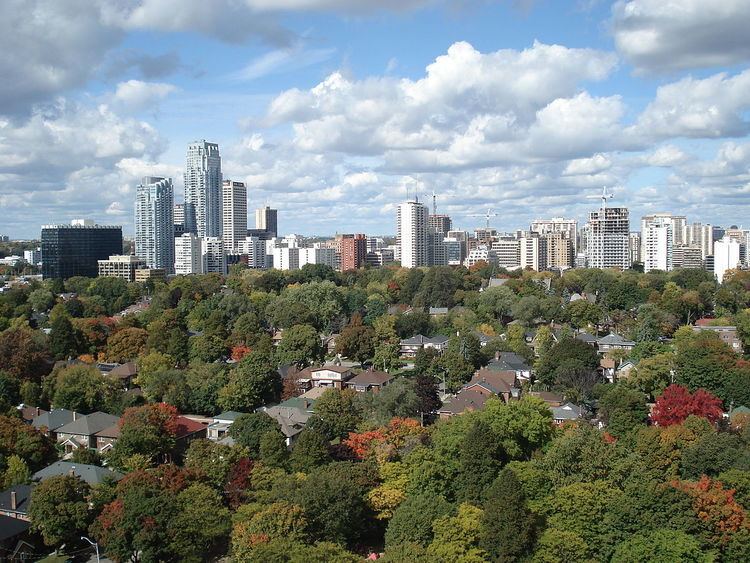
Davisville Village is an area of Toronto near the intersection of Davisville Avenue and Yonge Street. There is a subway station named Davisville at this intersection. The area directly abuts Mount Pleasant Cemetery, and has a large number of massive apartment and condominium complexes built between the 1970s and the 2000s, as well as a number of office buildings. The area is an attractive area in Midtown Toronto between St Clair and Eglinton. Davisville Village is represented at Toronto City Council by Councillor Josh Matlow (Ward 22).
Contents
- Davisville village toronto canada
- Map of Davisville Toronto ON Canada
- Midtown yonge and eglinton davisville village mount pleasant www torontorealtyblog com
- History
- Population
- Income
- Diversity
- Transportation
- Real Estate
- Physical environment
- Divisions
- References
Map of Davisville, Toronto, ON, Canada
Midtown yonge and eglinton davisville village mount pleasant www torontorealtyblog com
History
Davisville was founded by John Davis in 1840. Davis opened the first post office in the neighbourhood and served as the post-master. The building that housed the original post office is currently a Starbucks at the North-East corner of Yonge Street and Davisville Avenue. John Davis also started Davisville Pottery Company, which was the largest employer in the neighbourhood for several years. In 1911 Davis sold a large portion of the land to Dovercourt Development Company to be developed. Many single family homes were built between the 1920s-1930s and still exist today.
Population
Population - The population of Davisville Village as of 2006 was 23,690. The population of Davisville grew approximately 6.5% between 1996 and 2001, and another 8.5% between 2001 and 2006.
Davisville is a densely populated neighbourhood. It consists of many medium and high-rise buildings, especially in the area west of Mt. Pleasant Road. There are 23,690 people in Davisville, in an area of approximately 2.23 km2, giving it a density of approximately 10,623 people per km2.
Income
Davisville is a fairly wealthy neighbourhood. Approximately 33% of Davisville's households earn more than $60,000 per year, which is more than double Toronto, which has an approximately 16.2% of its households earning more than $60,000 per year.
Diversity
Diversity - Davisville has a higher percentage of Canadian citizens than Toronto according to the 2006 census data. Almost 48% of Davisville residents are Canadian citizens compared to 46% in city of Toronto. Between 1961 and 1981 the immigrant population in Davisville remained fairly consistent at approximately 17% of the total population. By 1981 the immigrant population in Davisville increased rapidly and has continued to do so for the past three decades.
The immigrants in Davisville come from many different countries. The country where most of Davisville's immigrants come from is the United Kingdom. In 2006 there were 955 people living in Davisville from the United Kingdom. There are also 480 immigrants living in Davisville from the United States of America and 470 immigrants from Iran. Other countries of origin for Davisville immigrants are China, India, Philippines, Germany, Poland, Jamaica, South Korea, Romania and Russia.
Transportation
Davisville is serviced by 2 TTC subway stations, Davisville and Eglinton station on the Yonge-University line. It also has regular bus service on Eglinton Ave. E. and Bayview Ave. The easy access to public transportation and the proximity to the Downtown core, results in a higher percentage of residents using public transit and self-propulsion (walking/biking). Davisville's transportation mode shows that 46.5% of residents use public transit and 11.9% walked or biked to their destination, compared to the City of Toronto's transportation mode which shows that only 34.4% of residents use public transit and 8.8% walk or bike. The 2006 census data also shows that Davisville neighbourhood has a lower percentage of vehicle users than the city of Toronto. 40.1% of residents in Davisville use car, trucks, vans, and/or motorcycles to get to their destination compared to Toronto's 55.8%.
Real Estate
Like many of Toronto's neighbourhoods, the real estate market in Davisville has undergone incredible growth over the past several years. Davisville has actually outperformed the Toronto real estate market in general in 2015 and thus far in 2016. The average price of a detached home is now $1,365,749 . which is an increase of 16% over 2015. A major part of the real estate price growth in Davisville stems from its proximity to some of the cities best schools (Maurice Cody - Junior School, North Toronto Collegiate Institute - Highschool), transportation (The Don Valley Parkway, Bayview Extension and Davisville Subway) as well as shopping and restaurants.
Physical environment
Davisville Village is a unique neighbourhood with several distinct features. These features help people to understand their surroundings and navigate themselves within the neighbourhood. One of the most renowned theories of understanding these features is that of Kevin Lynch, an urban planner who outlined five elements people use to understand their surroundings:
Districts – There are 2 main districts in Davisville. The first district is at the corner of Yonge Street and Eglinton Avenue, an entertainment area within the neighbourhood with several restaurants, bars, Yonge Eglinton Centre and several office buildings. The second is Mt. Pleasant Road between Eglinton Avenue and Davisville Avenue, a mixed-use street with independent stores, gift shops, restaurants and homes.
Nodes – The main nodes in Davisville are Yonge & Eglinton and Yonge & Davisville. These nodes are popular, recognizable meeting places for people and transportation hubs. These nodes are intersections of major streets.
Paths – The frequent paths in Davisville are Yonge Street, Bayview Avenue, Mt Pleasant Road, Davisville Avenue and Eglinton Avenue.
Edges – The edges of Davisville are Yonge Street (West), Bayview Avenue (East), Eglinton Avenue (North) and Merton Street (South)
Landmarks – Yonge-Eglinton Centre, a mid-size shopping centre with several major chain stores and restaurants, is a frequently cited landmark. Minto Midtown Quantum towers, the largest residential condominium towers in Davisville, are also landmarks in the neighbourhood. Davisville Park is a landmark located at the corner of Davisville avenue and Mt. Pleasant Road.
One of the most important physical elements of Davisville Village is the streets. Davisville is a busy neighbourhood that accommodates high-pedestrian traffic because of its streets. Jane Jacobs, a long time Toronto resident and author identified 4 elements that make good streets. The first element described by Jacobs is Various types of aged buildings. Davisville has a mix of houses built in the early half of the 20th century as well as new, modern condominium buildings, apartments and offices which creates a mix of new and old buildings in the neighbourhood. Another important element of good streets is High concentration and density uses. Davisville is a very densely populated neighbourhood. The density helps make the neighbourhood sustainable and safe. Good streets also incorporate Mixed-use areas. Mt. Pleasant is a frequent mixed-use street within Davisville. The fourth and final element of good streets is Frequent streets and very few long blocks. The streets within and surrounding Davisville are frequently spaced, with very wide sidewalks that accommodate high pedestrian traffic.
Divisions
The city of Toronto assigns the Davisville Village into two neighbourhoods:
Mount Pleasant West is situated West of Mount Pleasant Road, North of Merton Street, East of Yonge Street and South of Keewatin Ave. 91% of people in this neighbourhood live in low/high rise apartment and condo buildings, which makes it one of the most building-dominated neighbourhoods in Toronto (comparable to the high-rise dense downtown core; Source: Statistics Canada). There are a number of affordable housing units in the area which factors into the lower income levels in this neighbourhood compared to the surrounding ones. Over 80% of residents are renters, which is approximately 30% over Toronto's average.
Minto Midtown In 2003 Minto proposed a plan for two high-rise condominium buildings on Yonge street, south of Eglinton avenue. A majority of Davisville residents were strongly opposed to the development. The case was taken to the Ontario Municipal Board (OMB), which agreed that in order for Minto's plans to be approved, they needed to comply with the following conditions:
The Minto Quantum towers were built and completed in 2007 (Coorsh, 2010).
Mount Pleasant East is bordered to the east by Bayview Ave, Moore Ave to the South, Yonge street to the West and Blythwood to the North. The people in this neighbourhood are predominantly in their working years and enjoy an average income and average house value well above the norm for the city (Statistics Canada). While not the most affluent of neighbourhoods it is comparable to The Beaches in demographics and income.