The 2007 Pacific typhoon season had no official bounds; it ran year-round in 2007, but most tropical cyclones tend to form in the northwestern Pacific Ocean between May and November. These dates conventionally delimit the period of each year when most tropical cyclones form in the northwestern Pacific Ocean.
For the PAGASA, only 13 systems formed or entered in their area during 2007, which only 3 of them directly made landfall over the Philippines.
The following timeline documents the major events in the season with regards to tropical cyclone formation, strengthening, weakening, landfall, extratropicality and dissipation. Please note that the Japan Meteorological Agency (JMA) is considered to be official for this tropical cyclone basin; Philippine Atmospheric, Geophysical and Astronomical Services Administration (PAGASA) is only responsible for Philippines warnings while the Joint Typhoon Warning Center (JTWC) releases unofficial advisories for the United States Military in the Marianas, Japan and South Korea.
All landfalls are bolded and referred to in JMA terms. The JTWC storms are referred to numerically, to avoid confusion, as the JTWC sometimes recognises a storm at a different intensity compared to the JMA. For the purposes of the timeline, all events stemming from JTWC advisories will be documented by time of issuance, rather than by the operational time of observed information (3 hours before). It should be noted that the timeline does not deal with the end of PAGASA-monitored storms; if the JTWC or the JMA did not monitor such a storm it should be assumed that the storm did not cause major damage or make landfall, and simply dissipated or left the area of jurisdiction of PAGASA.
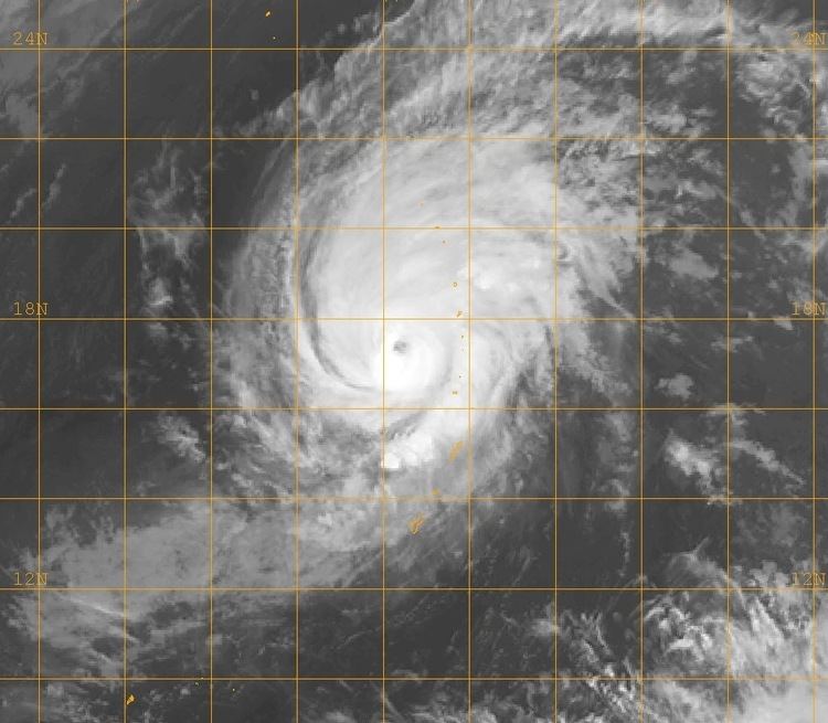
There was no tropical activity in the Western North Pacific basin during January.There was no tropical activity in the Western North Pacific basin during February.March 3112 a.m. (1200 UTC March 30) – The Japan Meteorological Agency (JMA) begins monitoring a Tropical Depression located 75 miles (125 km) south of Palikir, Pohnpei.April 112 a.m. (1200 UTC March 31) – The Joint Typhoon Warning Center (JTWC) begins issuing advisories on Tropical Depression 01W located 240 miles (385 km) northwest of Palikir, Pohnpei.6 a.m. (1800 UTC March 31) – The JTWC upgrades Tropical Depression 01W to a tropical storm.12 p.m. (0000 UTC) – The JMA upgrades the tropical depression to Tropical Storm Kong-rey.April 26 p.m. (0600 UTC) – The JTWC upgrades Tropical Storm 01W (Kong-rey) to a typhoon.6 a.m. (1800 UTC April 2) – The JMA upgrades Tropical Storm Kong-rey to a severe tropical storm.April 312 p.m. (0000 UTC) – The JMA upgrades Severe Tropical Storm Kong-rey to a typhoon.April 412 a.m. (1200 UTC April3) – The JTWC upgrades Typhoon 01W (Kong-rey) to a Category 3 typhoon.6 a.m. (1800 UTC April 3) – The JTWC downgrades Typhoon 01W (Kong-rey) to a Category 2 typhoon.12 p.m. (0000 UTC) – The JTWC downgrades Typhoon 01W (Kong-rey) to a Category 1 typhoon.April 512 a.m. (1200 UTC April 4) – The JTWC downgrades Typhoon 01W (Kong-rey) to a tropical storm.6 a.m. (1800 UTC April 4) – The JMA downgrades Typhoon Kong-rey to a severe tropical storm.12 p.m. (0000 UTC) – The JTWC declares Tropical Storm 01W (Kong-rey) extratropical.6 p.m. (0600 UTC) – The JMA downgrades Severe Tropical Storm Kong-rey to a tropical storm.April 612 p.m. (0000 UTC) – The JMA declares Tropical Storm Kong-rey extratropical.May 163 p.m. UTC - Tropical Depression 02W forms east of Yap.May 176 a.m. UTC - The JMA designates Tropical Depression 02W as Tropical Storm Yutu.9 a.m. UTC - The JTWC upgrades Tropical Depression 02W to Tropical Storm 02W (Yutu).May 186 a.m. UTC - The JMA upgrades Tropical Storm Yutu to Severe Tropical Storm Yutu.8 a.m. UTC - PAGASA designates Severe Tropical Storm Yutu as Tropical Storm Amang.3 p.m. UTC - The JTWC upgrades Tropical Storm 02W to Typhoon 02W (Yutu).6 p.m. UTC - The JMA upgrades Severe Tropical Storm Yutu to Typhoon Yutu.May 192.45 a.m. UTC - PAGASA upgrades Tropical Storm Amang to Typhoon Amang (Yutu).May 223 a.m. UTC - The JTWC issues its final warning on Typhoon 02W (Yutu), in the process of extratropical transition.9 a.m. UTC - The JMA downgrades Typhoon Yutu to a severe tropical storm.3 p.m. UTC - The JMA downgrades Severe Tropical Storm Yutu to a tropical storm.May 2312 a.m. UTC - The JMA issues its final warning on the extratropical remnants of Tropical Storm Yutu.There was no tropical storm activity in the Western North Pacific basin in June.July 49 a.m. UTC - Tropical Storm 03W forms just southeast of Hainan Island.3 p.m. UTC - The JTWC downgrades Tropical Storm 03W to a tropical depression.9 p.m. UTC - The JTWC upgrades Tropical Depression 03W back to Tropical Storm 03W.July 512 a.m. UTC - The JMA designates Tropical Storm 03W as Tropical Storm Toraji.c. 12 p.m. UTC - Tropical Storm Toraji makes landfall in northeastern Vietnam.3 p.m. UTC - The JTWC downgrades Tropical Storm 03W (Toraji) to a tropical depression, and issues its final advisory as it dissipates over northern Vietnam.6 p.m. UTC - The JMA downgrades Tropical Storm Toraji to a tropical depression and issues its final advisory.July 73 p.m. UTC - Tropical Depression 04W forms south-southeast of Guam.9 p.m. UTC - The JTWC upgrades Tropical Depression 04W to Tropical Storm 04W.July 86 p.m. UTC - The JMA designates Tropical Storm 04W as Tropical Storm Man-yi.July 96 p.m. UTC - The JMA upgrades Tropical Storm Man-yi to Severe Tropical Storm Man-yi.July 109 a.m. UTC - The JTWC upgrades Tropical Storm 04W (Man-yi) to Typhoon 04W (Man-yi).6 p.m. UTC - The JMA upgrades Severe Tropical Storm Man-yi to Typhoon Man-yi.9 p.m. UTC - PAGASA designates Typhoon Man-yi as Typhoon Bebeng.July 129 p.m. UTC - The JTWC upgrades Typhoon 04W to Super Typhoon 04W (Man-yi).July 133 a.m. UTC - The JTWC downgrades Super Typhoon 04W (Man-yi) to a typhoon.9 a.m. UTC - The JTWC re-upgrades Typhoon 04W (Man-yi) to a super typhoon.3 p.m. UTC - The JTWC downgrades Super Typhoon 04W (Man-yi) to a typhoon.July 14c. 4 a.m. UTC - Typhoon Man-yi makes its first landfall in Kagoshima Prefecture on Kyūshū.c. 9 a.m. UTC - Typhoon Man-yi makes its second landfall in Kōchi Prefecture on Shikoku.9 p.m. UTC - The JTWC downgrades Typhoon 04W (Man-yi) to a tropical storm.c. 11 p.m. UTC - Typhoon Man-yi makes its third landfall in Wakayama Prefecture on Honshū.July 1512 a.m. UTC - The JMA downgrades Typhoon Man-yi to a severe tropical storm.9 a.m. UTC - The JTWC issues its final advisory on the extratropical remnants of Tropical Storm 04W (Man-yi).6 p.m. UTC - The JMA downgrades Severe Tropical Storm Man-yi to a tropical storm.July 1712 a.m. UTC - The JMA issues its final advisory on the extratropical remnants of Tropical Storm Man-yi.July 283 p.m. UTC - Tropical Depression 05W forms northeast of Saipan.9 p.m. UTC - The JTWC upgrades Tropical Depression 05W to Tropical Storm 05W.July 296 a.m. UTC - The JMA designates Tropical Storm 05W as Tropical Storm Usagi.9 p.m. UTC - The JTWC upgrades Tropical Storm 05W to Typhoon 05W (Usagi).July 3012 a.m. UTC - The JMA upgrades Tropical Storm Usagi to Severe Tropical Storm Usagi.August 2c. 8 a.m. UTC - Typhoon Usagi makes landfall near Nobeoka, Miyazaki.12 p.m. UTC - The JMA downgrades Typhoon Usagi to a severe tropical storm.c. 5 p.m. UTC - Severe Tropical Storm Usagi makes landfall near Ube, Yamaguchi.6 p.m. UTC - Tropical Depression 06W forms southeast of Huế, Vietnam.August 312 a.m. UTC - The JMA downgrades Severe Tropical Storm Usagi to a tropical storm.August 43 a.m. UTC - The JTWC upgrades Tropical Depression 06W to Tropical Storm 06W.c. 4 a.m. UTC - Tropical Storm Usagi makes landfall on the Tsugaru Peninsula in Aomori Prefecture on Honshū.c. 5 a.m. UTC - Tropical Storm Usagi makes a fourth landfall, near Wakinosawa, Aomori.12 p.m. UTC - The JMA issues its final warning on the extratropical remnants of Tropical Storm Usagi.3 p.m. UTC - The JTWC downgrades Tropical Storm 06W to a tropical depression.August 56 a.m. UTC - The JMA designates 98W.INVEST as Tropical Storm Pabuk.9 a.m. UTC - The JTWC designates Tropical Storm Pabuk as Tropical Storm 07W, northwest of Guam.9 a.m. UTC - PAGASA designates Tropical Storm Pabuk as Tropical Storm Chedeng.August 66 a.m. UTC - The JMA upgrades Tropical Storm Pabuk to Severe Tropical Storm Pabuk.August 73 a.m. UTC - The JTWC upgrades Tropical Storm 07W to Typhoon 07W (Pabuk).9 a.m. UTC - The JTWC issues its final warning on dissipating Tropical Depression 06W.9 a.m. UTC - The JMA upgrades Severe Tropical Storm Pabuk to Typhoon Pabuk.3 p.m. UTC - Tropical Depression 08W forms east-northeast of Manila, the Philippines.3 p.m. UTC - The JTWC downgrades Typhoon 07W (Pabuk) to a tropical storm.3 p.m. UTC - The JMA downgrades Typhoon Pabuk to a severe tropical storm.c. 4:30 p.m. UTC - Severe Tropical Storm Pabuk makes landfall on the Hengchun Peninsula in Pingtung County in southern Taiwan.9 p.m. UTC - The JTWC reupgrades Tropical Storm 07W to Typhoon 07W (Pabuk).August 812 a.m. UTC - The JMA designates Tropical Depression 08W as Tropical Storm Wutip.3 a.m. UTC - The JTWC redowngrades Typhoon 07W (Pabuk) to a tropical storm.3 a.m. UTC - PAGASA designates Tropical Storm Wutip as Tropical Depression Dodong.9 a.m. UTC - PAGASA upgrades Tropical Depression Dodong to Tropical Storm Dodong (Wutip).9 a.m. UTC - The JTWC upgrades Tropical Depression 08W to Tropical Storm 08W (Wutip).6 p.m. UTC - The JMA downgrades Severe Tropical Storm Pabuk to a tropical storm.August 96 a.m. UTC - The JMA downgrades Tropical Storm Wutip to a tropical depression and issues its last advisory.9 a.m. UTC - The JTWC downgrades Tropical Storm 08W (Wutip) to a tropical depression.9 a.m. UTC - The JTWC downgrades Tropical Storm 07W (Pabuk) to a tropical depression.12 p.m. UTC - The JMA downgrades Tropical Storm Pabuk to a tropical depression and issues its last advisory.9 p.m. UTC - The JTWC issues its last advisory on Tropical Depression 07W (Pabuk).9 p.m. UTC - The JTWC issues its last advisory on Tropical Depression 08W (Wutip).August 129 a.m. UTC - Tropical Depression 09W forms northwest of Guam.3 p.m. UTC - The JTWC upgrades Tropical Depression 09W to Tropical Storm 09W.6 p.m. UTC - The JMA designates Tropical Depression 09W as Tropical Storm Sepat.August 133 a.m. UTC - PAGASA designates Tropical Storm Sepat as Tropical Storm Egay.6 a.m. UTC - The JMA upgrades Tropical Storm Sepat to Severe Tropical Storm Sepat.August 1412 a.m. UTC - The JMA upgrades Severe Tropical Storm Sepat to Typhoon Sepat.3 a.m. UTC - The JTWC upgrades Tropical Storm 09W to Typhoon 09W (Sepat).August 153 a.m. UTC - The JTWC upgrades Typhoon 09W to Super Typhoon 09W (Sepat).August 179 a.m UTC - The JTWC downgrades Super Typhoon 09W (Sepat) to a typhoon.c. 9 p.m. UTC - Typhoon Sepat makes landfall in Taitung County, Taiwan.August 1812 p.m. UTC - The JMA downgrades Typhoon Sepat to a severe tropical storm.c. 9 p.m. UTC - Severe Tropical Storm Sepat makes landfall in Fujian Province, China.August 1912 a.m. UTC - The JMA downgrades Severe Tropical Storm Sepat to a tropical storm.3 a.m. UTC - The JTWC downgrades Typhoon 09W (Sepat) to a tropical storm and issues its last advisory, as the storm dissipates inland in China.August 2012 a.m. UTC - The JMA issues it last advisory on Tropical Storm Sepat.August 289 p.m. UTC - Tropical Depression 10W forms east-northeast of Saipan.August 296 a.m. UTC - The JMA designates Tropical Depression 10W as Tropical Storm Fitow.3 a.m. UTC - The JTWC upgrades Tropical Depression 10W to Tropical Storm 10W.12 p.m. UTC - The JMA upgrades Tropical Storm Fitow to Severe Tropical Storm Fitow.9 p.m. UTC - The JTWC upgrades Tropical Storm 10W to Typhoon 10W (Fitow).August 3012 p.m. UTC - The JMA upgrades Severe Tropical Storm Fitow to Typhoon Fitow.September 312 p.m. UTC - The JMA downgrades Typhoon Fitow to a severe tropical storm.September 512 a.m. UTC - The JMA reupgrades Severe Tropical Storm Fitow to Typhoon Fitow.September 6c. 3 p.m. UTC - Typhoon Fitow makes its first landfall at Izu Peninsula in Shizuoka Prefecture on Honshū.September 712 a.m. UTC - The JMA downgrades Typhoon Fitow to a severe tropical storm.3 a.m. UTC - The JTWC downgrades Typhoon 10W (Fitow) to a tropical storm.9 a.m. UTC - The JTWC issues its final warning on Tropical Storm 10W (Fitow), in the process of extratropical transition.9 a.m. UTC - Tropical Depression 11W forms far east of Iōtō.12 p.m. UTC - The JMA designates Tropical Depression 11W as Tropical Storm Danas.3 p.m. UTC - The JMA downgrades Severe Tropical Storm Fitow to a tropical storm.3 p.m. UTC - The JTWC upgrades Tropical Depression 11W to Tropical Storm 11W.c. 4 p.m. UTC - Tropical Storm Fitow makes its second landfall on the Oshima Peninsula, near Hakodate, Hokkaidō.c. 7 p.m. UTC - Tropical Storm Fitow makes its third landfall near Abuta, Hokkaidō.c. 10 p.m. UTC - Tropical Storm Fitow makes its final landfall near Atsuta, Hokkaidō.September 86 a.m. UTC - The JMA issues its final warning on the extratropical remnants of Tropical Storm Fitow.September 96 p.m. UTC - The JMA upgrades Tropical Storm Danas to Severe Tropical Storm Danas.September 113 a.m. UTC - The JTWC issues its final warning on Tropical Storm 11W (Danas), in the process of extratropical transition.12 p.m. UTC - The JMA downgrades Severe Tropical Storm Danas to a tropical storm.6 p.m. UTC - The JMA issues its final warning on the extratropical remnants of Tropical Storm Danas.September 126 p.m. UTC - Tropical Depression 12W forms southwest of Naha, Okinawa.September 133:45 a.m. UTC - PAGASA designates Tropical Depression 12W as Tropical Depression Falcon.6 a.m. UTC - The JMA designates Tropical Depression 12W as Tropical Storm Nari.9 a.m. UTC - The JTWC upgrades Tropical Depression 12W to Tropical Storm 12W (Nari).3 p.m. UTC - PAGASA upgrades Tropical Depression Falcon to Tropical Storm Falcon (Nari).6 p.m. UTC - The JMA upgrades Tropical Storm Nari to Severe Tropical Storm Nari.9 p.m. UTC - The JTWC upgrades Tropical Storm 12W (Nari) to Typhoon 12W (Nari).September 1412 a.m. UTC - The JMA upgrades Severe Tropical Storm Nari to Typhoon Nari.2:45 a.m. UTC - PAGASA upgrades Tropical Storm Falcon (Nari) to Typhoon Falcon (Nari).c. 12 p.m. UTC - Typhoon Nari grazes Kumejima, due west of Okinawa Island.September 159 a.m. UTC - Tropical Depression 13W forms southeast of Naha, Okinawa.9 a.m. UTC - PAGASA designates Tropical Depression 13W as Tropical Depression Goring.September 1612 a.m. UTC - The JMA designates Tropical Depression 13W as Tropical Storm Wipha.3 a.m. UTC - The JTWC upgrades Tropical Depression 13W to Tropical Storm 13W (Wipha).3 a.m. UTC - PAGASA upgrades Tropical Depression Goring to Tropical Storm Goring (Wipha).c. 4:30 a.m. UTC - Typhoon Nari grazes Jeju-do, just southwest of mainland South Korea.c. 8:30 a.m. UTC - Typhoon Nari makes landfall in southeastern Jeollanam province, on the Korean Peninsula.12 p.m. UTC - The JMA downgrades Typhoon Nari to a severe tropical storm.12 p.m. UTC - The JMA upgrades Tropical Storm Wipha to Severe Tropical Storm Wipha.3 p.m. UTC - The JMA downgrades Severe Tropical Storm Nari to a tropical storm.3 p.m. UTC - The JTWC downgrades Typhoon 12W (Nari), in the process of extratropical transition, to a tropical storm, and issues its final warning.3 p.m. UTC - The JTWC upgrades Tropical Storm 13W to Typhoon 13W (Wipha).3 p.m. UTC - PAGASA upgrades Tropical Storm Goring to Severe Tropical Storm Goring (Wipha).c. 10 p.m. UTC - Tropical Storm Nari passes over Ulleungdo, due east of Seoul in the Sea of Japan.September 1712 a.m. UTC - The JMA issues its final warning on the extratropical remnants of Tropical Storm Nari.3 a.m. UTC - The JMA upgrades Severe Tropical Storm Wipha to Typhoon Wipha.3 a.m. UTC - PAGASA upgrades Severe Tropical Storm Goring to Typhoon Goring (Wipha).9 p.m. UTC - The JTWC upgrades Typhoon 13W to Super Typhoon 13W (Wipha).c. 10 p.m. - Typhoon Wipha passes over Iriomote, due east of Hualien City.September 183 p.m. UTC - The JTWC downgrades Super Typhoon 13W (Wipha) to a typhoon.c. 6 p.m. UTC - Typhoon Wipha makes landfall over Fuding, near the Fujian-Zhejiang provincial border.September 193 a.m. UTC - The JMA downgrades Typhoon Wipha to a severe tropical storm.9 a.m. UTC - The JMA downgrades Severe Tropical Storm Wipha to a tropical storm.9 a.m. UTC - The JTWC downgrades Typhoon 13W (Wipha), in the process of extratropical transition, to a tropical storm, and issues its final warning.12 p.m. UTC - The JMA downgrades Tropical Storm Wipha to a tropical depression, and issues its final warning.September 203 p.m. UTC - Tropical Depression 14W forms west of Guam.September 213 p.m. UTC - The JTWC issues its final warning on Tropical Depression 14W, dissipating over water.September 233 a.m. UTC - Tropical Depression 15W forms south-southeast of Hong Kong.12 p.m. UTC - The JMA designates Tropical Depression 15W as Tropical Storm Francisco.3 p.m. UTC - The JTWC upgrades Tropical Depression 15W to Tropical Storm 15W (Francisco).September 243 a.m. UTC - Tropical Storm Francisco makes landfall near Wenchang on Hainan Island.6 p.m. UTC - The JTWC downgrades Tropical Storm 15W (Francisco) to a tropical depression.September 253 a.m. UTC - The JTWC issues its final warning on Tropical Depression 15W (Francisco), dissipating over water.6 a.m. UTC - The JMA downgrades Tropical Storm Francisco to a tropical depression, and issues its final warning.September 279 a.m. UTC - PAGASA designates 98W.INVEST, east of the Philippines, as Tropical Depression Hanna.September 289 a.m. UTC - PAGASA upgrades Tropical Depression Hanna to Tropical Storm Hanna.September 29c. 1 a.m. UTC - Tropical Storm Hanna makes landfall in Dilasag, Aurora on Luzon.3 a.m. UTC - PAGASA downgrades Tropical Storm Hanna to a tropical depression.September 3012 a.m. - The JMA designates 90W.INVEST, now the same system as Tropical Depression Hanna, as Tropical Storm Lekima.3 a.m. UTC - The JTWC designates Tropical Storm Lekima as Tropical Depression 16W, east-northeast of Nha Trang, Vietnam.9 a.m. UTC - The JTWC upgrades Tropical Depression 16W to Tropical Storm 16W (Lekima).9 p.m. UTC - The JMA upgrades Tropical Storm Lekima to Severe Tropical Storm Lekima.October 14 a.m. UTC - PAGASA designates 91W.INVEST as Tropical Depression Ineng.3 p.m. UTC - The JTWC designates Tropical Depression Ineng as Tropical Depression 17W, far east-northeast of Manila, the Philippines.3 p.m. UTC - PAGASA upgrades Tropical Depression Ineng to Tropical Storm Ineng.6 p.m. UTC - The JTWC upgrades Tropical Depression 17W to Tropical Storm 17W.October 212 a.m. UTC - The JMA designates Tropical Storm 17W (Ineng) as Tropical Storm Krosa.9 a.m. UTC - The JTWC upgrades Tropical Storm 16W to Typhoon 16W (Lekima).3 p.m. UTC - The JTWC upgrades Tropical Storm 17W to Typhoon 17W (Krosa).6 p.m. UTC - The JMA upgrades Tropical Storm Krosa to Severe Tropical Storm Krosa.October 33 a.m. UTC - PAGASA upgrades Tropical Storm Ineng to Typhoon Ineng (Krosa).6 a.m. UTC - The JMA upgrades Severe Tropical Storm Krosa to Typhoon Krosa.c. 12 p.m. UTC - Severe Tropical Storm Lekima makes landfall on the North Central Coast of Vietnam.c. 6 p.m. UTC - The JMA downgrades Severe Tropical Storm Lekima to a tropical storm.9 p.m. UTC - The JTWC downgrades Typhoon 16W (Lekima) to a tropical storm and issues its final warning as the storm dissipates inland in Indochina.October 46 a.m. UTC - The JMA downgrades Tropical Storm Lekima to a tropical depression, and issues its final warning.October 53 a.m. UTC - The JTWC upgrades Typhoon 17W to Super Typhoon 17W (Krosa).October 612 a.m. UTC - The JMA designates 93W.INVEST as Tropical Storm Haiyan.3 a.m. UTC - The JTWC downgrades Super Typhoon 17W (Krosa) to a typhoon.c. 3 a.m. UTC - Typhoon Krosa grazes Yonaguni, due east of Hualien.6 a.m. UTC - The JMA designates 92W.INVEST as Tropical Storm Podul.c. 8 a.m. UTC - Typhoon Krosa makes landfall near Su-ao, Yilan in northeastern Taiwan.c. 3 p.m. UTC - Typhoon Krosa makes a second landfall near Gongliao, Taipei, also in northeastern Taiwan.6 p.m. UTC - The JMA downgrades Tropical Storm Haiyan to a tropical depression and issues its final advisory.October 712 a.m. UTC - The JMA issues its final advisory on the extratropical remnants of Tropical Storm Podul.12 a.m. UTC - The JMA downgrades Typhoon Krosa to a severe tropical storm.c. 9 a.m. UTC - Severe Tropical Storm Krosa makes landfall over Fuding, near the Fujian-Zhejiang provincial border.9 a.m. UTC - The JTWC downgrades Typhoon 17W (Krosa) to a tropical storm.October 812 a.m. UTC - The JMA downgrades Severe Tropical Storm Krosa to a tropical storm.12 p.m. UTC - The JMA issues its final advisory on the remnants of Tropical Storm Krosa, dissipating just off the coast of China.9 p.m. UTC - The JTWC downgrades Tropical Storm 17W (Krosa) to a tropical depression and issues its final advisory.October 126 a.m. UTC - The JMA designates 97W.INVEST as Tropical Storm Lingling.9 a.m. UTC - The JTWC designates Tropical Storm Lingling as Tropical Depression 18W, far west-southwest of Midway Atoll.3 p.m. UTC - The JTWC upgrades Tropical Depression 18W to Tropical Storm 18W (Lingling).October 139 p.m. UTC - The JTWC downgrades Tropical Storm 18W (Lingling) to a tropical depression and issues its final advisory.October 156 a.m. UTC - The JMA issues its final advisory on the extratropical remnants of Tropical Storm Lingling.October 193 a.m. UTC - Tropical Depression 19W forms north-northwest of Saipan.6 a.m. UTC - The JMA designates Tropical Depression 19W as Tropical Storm Kajiki.9 a.m. UTC - The JTWC upgrades Tropical Depression 19W to Tropical Storm 19W (Kajiki).12 p.m. UTC - The JMA upgrades Tropical Storm Kajiki to Severe Tropical Storm Kajiki.9 p.m. UTC - The JTWC upgrades Tropical Storm 19W to Typhoon 19W (Kajiki).October 2012 a.m. UTC - The JMA upgrades Severe Tropical Storm Kajiki to Typhoon Kajiki.October 213 p.m. UTC - The JTWC issues its final advisory on Typhoon 19W (Kajiki) as it completes extratropical transition.6 p.m. UTC - The JMA downgrades Typhoon Kajiki to a severe tropical storm.October 226 a.m. UTC - The JMA issues its final advisory on the extratropical remnants of Severe Tropical Storm Kajiki.October 2612 a.m. UTC - The JMA designates 94W.INVEST as Tropical Storm Faxai.2 a.m. UTC - PAGASA designates Tropical Storm Faxai as Tropical Depression Juaning.3 a.m. UTC - The JTWC designates Tropical Storm Faxai as Tropical Depression 20W, southeast of Naha, Okinawa.3 p.m. UTC - The JTWC declares Tropical Depression 20W (Faxai) extratropical and discontinues advisories.3 p.m. UTC - PAGASA upgrades Tropical Depression Juaning to Tropical Storm Juaning (Faxai).9 p.m. UTC - The JTWC resumes advisories on Faxai, now declaring it Tropical Storm 20W (Faxai).October 2712 a.m. UTC - The JMA upgrades Tropical Storm Faxai to Severe Tropical Storm Faxai.3 a.m. UTC - The JTWC issues its last advisory on Tropical Storm 20W (Faxai), now completely extratropical.6 p.m. UTC - The JMA issues its last advisory on the extratropical remnants of Severe Tropical Storm Faxai.November 39 a.m. UTC - Tropical Depression 21W forms far east-northeast of Manila, the Philippines.9 a.m. UTC - PAGASA designates Tropical Depression 21W as Tropical Depression Kabayan.12 p.m. UTC - The JMA designates Tropical Depression 21W as Tropical Storm Peipah.3 p.m. UTC - PAGASA upgrades Tropical Depression Kabayan to Tropical Storm Kabayan (Peipah).3 p.m. UTC - The JTWC upgrades Tropical Depression 21W to Tropical Storm 21W (Peipah).November 412 a.m. UTC - The JMA upgrades Tropical Storm Peipah to Severe Tropical Storm Peipah.c. 1 p.m. UTC - Severe Tropical Storm Peipah makes landfall in Palanan, Isabela.3 p.m. UTC - The JTWC upgrades Tropical Storm 21W to Typhoon 21W (Peipah).November 53 a.m. UTC - The JTWC downgrades Typhoon 21W (Peipah) to a tropical storm.9 p.m. UTC - The JTWC upgrades Tropical Storm 21W to Typhoon 21W (Peipah).November 63 a.m. UTC - The JMA upgrades Severe Tropical Storm Peipah to Typhoon Peipah.9 a.m. UTC - PAGASA upgrades Tropical Storm Kabayan to Typhoon Kabayan (Peipah).November 76 a.m. UTC - The JMA downgrades Typhoon Peipah to a severe tropical storm.3 p.m. UTC - The JTWC downgrades Typhoon 21W (Peipah) to a tropical storm.3 p.m. UTC - The JMA downgrades Severe Tropical Storm Peipah to a tropical storm.November 83 a.m. UTC - The JTWC downgrades Tropical Storm 21W (Peipah) to a tropical depression.November 912 a.m. UTC - The JMA downgrades Tropical Storm Peipah to a tropical depression and issues its final advisory.3 p.m. UTC - The JTWC issues its final advisory on Tropical Depression 21W (Peipah), dissipating off the coast of Vietnam.November 113 p.m. UTC - Tropical Depression 22W forms south-southwest of Iōtō.November 1212 a.m. UTC - The JMA designates Tropical Depression 22W as Tropical Storm Tapah.3 a.m. UTC - The JTWC upgrades Tropical Depression 22W to Tropical Storm 22W (Tapah).9 p.m. UTC - The JTWC downgrades Tropical Storm 22W (Tapah) to a tropical depression and issues its final advisory.November 1312 a.m. UTC - The JMA downgrades Tropical Storm Tapah to a tropical depression and issues its final advisory.November 189 p.m. UTC - Tropical Depression 23W forms just east of northern Mindanao.November 195:45 a.m. UTC - PAGASA designates Tropical Depression 23W as Tropical Depression Lando.9 a.m. UTC - PAGASA upgrades Tropical Depression Lando to Tropical Storm Lando.9 p.m. UTC - The JTWC upgrades Tropical Depression 23W to Tropical Storm 23W.November 209 a.m. UTC - Tropical Depression 24W forms north-northwest of Yap.12 p.m. UTC - The JMA designates Tropical Depression 24W as Tropical Storm Mitag.6 p.m. UTC - The JMA designates Tropical Storm 23W as Tropical Storm Hagibis.8 p.m. UTC - PAGASA designates Tropical Storm Mitag as Tropical Storm Mina.9 p.m. UTC - The JTWC upgrades Tropical Depression 24W to Tropical Storm 24W (Mitag).November 216 a.m. UTC - The JMA upgrades Tropical Storm Hagibis to Severe Tropical Storm Hagibis.12 p.m. UTC - The JMA upgrades Tropical Storm Mitag to Severe Tropical Storm Mitag.9 p.m. UTC - The JTWC upgrades Tropical Storm 23W to Typhoon 23W (Hagibis).9 p.m. UTC - The JTWC upgrades Tropical Storm 24W to Typhoon 24W (Mitag).November 2212 a.m. UTC - The JMA upgrades Severe Tropical Storm Hagibis to Typhoon Hagibis.12 a.m. UTC - The JMA upgrades Severe Tropical Storm Mitag to Typhoon Mitag.3 a.m. UTC - PAGASA upgrades Tropical Storm Mina to Typhoon Mina (Mitag).November 236 p.m. UTC - The JMA downgrades Typhoon Hagibis to a severe tropical storm.9 p.m. UTC - The JTWC downgrades Typhoon 23W (Hagibis) to a tropical storm.November 25c. 2 p.m. UTC - Severe Tropical Storm Mitag makes landfall near Palanan, Isabela.November 263 a.m. UTC - The JTWC downgrades Tropical Storm 23W (Hagibis) to a tropical depression.6 a.m. UTC - The JMA downgrades Severe Tropical Storm Hagibis to a tropical storm.6 a.m. UTC - The JMA downgrades Typhoon Mitag to a severe tropical storm.9 a.m. UTC - PAGASA downgrades Typhoon Mina (Mitag) to a tropical storm.9 a.m. UTC - Tropical Depression 25W forms south-southeast of Naha, Okinawa.9 p.m. UTC - The JTWC downgrades Typhoon 24W (Mitag) to a tropical storm.November 273 a.m. UTC - The JTWC issues its final advisory on Tropical Depression 23W (Hagibis) as it begins to dissipate.c. 8 a.m. UTC - Tropical Storm Hagibis makes landfall near Sablayan, Occidental Mindoro.c. 2 p.m. UTC - Tropical Storm Hagibis crosses several islands in Romblon province.3 p.m. UTC - PAGASA downgrades Tropical Storm Mina (Mitag) to a tropical depression.6 p.m. UTC - The JMA downgrades Tropical Storm Mitag to a tropical depression and issues its final advisory.c. 8 p.m. UTC - Tropical Storm Hagibis makes landfall near San Francisco, Quezon.9 p.m. UTC - The JTWC downgrades Tropical Storm 24W (Mitag) to a tropical depression and issues its final advisory, noting that the system is now extratropical.9 p.m. UTC - The JTWC issues its final advisory on Tropical Depression 25W as it completes extratropical transition.November 28c. 12 a.m. UTC - Tropical Storm Hagibis makes its final landfall near Pasacao, Camarines Sur.3 a.m. UTC - PAGASA issues its final advisory on Tropical Depression Mina (Mitag).3 a.m. UTC - The JMA downgrades Tropical Storm Hagibis to a tropical depression and issues its final advisory.9 a.m. UTC - PAGASA downgrades Tropical Depression Lando (Hagibis) to a low pressure area and issues its final advisory.3 p.m. UTC - Tropical Depression 26W forms west of Iōtō.9 p.m. UTC - The JTWC issues its final advisory on Tropical Depression 26W as it completes extratropical transition.There was no tropical activity in the Western North Pacific basin during December.