Status Functional Length 366 m | Opening date 21 February 1953 Height 30 m Opened 21 February 1953 | |
 | ||
Similar | ||
Boat ride at tilaiya dam
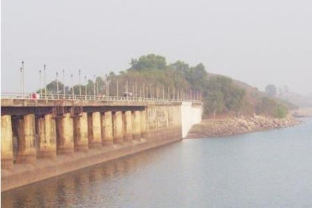
Tilaiya Dam (Hindi: तिलैया बांध) was the first of the four multi-purpose dams included in the first phase of the Damodar Valley Corporation. It was constructed across the Barakar River, at Tilaiya in Koderma district in the Indian state of Jharkhand and opened in 1953.
Contents
- Boat ride at tilaiya dam
- Map of Tilaiya Dam Kanti Jharkhand 825413
- DVC overview
- The dam
- Postal stamp
- Hazards
- References
Map of Tilaiya Dam, Kanti, Jharkhand 825413
DVC overview
As a result of the catastrophic flood of 1943, the Governor of Bengal appointed the Damodar Flood enquiry committee to suggest remedial measures. It suggested creation of an authority similar to that of the Tennessee Valley Authority in the United States. W.L.Voorduin, senior engineer of TVA prepared a preliminary report wherein he submitted an outline of a plan designed for achieving flood control, irrigation, power generation and navigation. As a result, Damodar Valley Corporation came into existence in 1948 for development and management of the basin as a whole. While Voorduin envisaged the construction of eight dams and a barrage but it was later decided to have only four dams at Tilaiya, Konar, Maithon and Panchet, and Durgapur Barrage
The first dam was built across the Barakar River at Tilaiya and inaugurated in 1953. The second dam across the Konar River was inaugurated in 1955. The third dam across the Barakar at Maithon was inaugurated in 1957. The fourth dam across the Damodar at Panchet was inaugurated in 1959.
The dam
The Tilaya Dam is located in the upper reaches of Barakar River, about 64.4 kilometres (40.0 mi) downstream of its source. The river at this site passes through a narrow gorge approximately 91.4 metres (300 ft) wide with banks steeply rising about 45.7 metres (150 ft) on either side. The dam has a catchment area of 984 square kilometres (380 sq mi) comprising mainly forests, pastures, cultivated lands and waste lands. The annual rainfall in the area is 127 centimetres (50 in).
The Tilaiya Dam is a concrete gravity dam with a maximum height of 30.2 metres (99 ft) above the river bed. The spillway has 14 tainter type crest gates of 3.05 m x 9.1 m, with a maximum discharge capacity of 3852 m³/s. Two modified butterfly type under sluice gates 1m high and 1.7 m wide with a discharge capacity of 14.2 m³/s are provided in the body of the dam mainly to supply irrigation water during the dry season.
Tilaiya Dam was inaugurated on 21 February 1953. It has a power generation capacity of 2 x 2 MW.
The main (Patna-Ranchi) road from Barhi on Grand Trunk Road passing through hills overlooking the reservoir is picturesque.
Postal stamp
The Indian Postal Service issued a set of four stamps for the Five-Year Plan series on 26 January 1955, that included one stamp of one anna value depicting Tilaiya Dam. The large engineering and construction projects of the 1950s, such as the Damodar Valley dams, were celebrated by a number of observers as embodiments of the vibrant spirit of the new nation. Shortly after opening the Tilaiya dam, pictured on the one-anna stamp, Nehru commented in a letter to the chief ministers that "the sight of those works filled me, as it did others who were present, with a sense of great achievement."
Hazards
Recently two engineers of Damodar Valley Corporation drowned while bathing in the Tilaiya Dam in Koderma district. The deceased engineers have been identified as Om Prakash Gupta and Prem Sourabh. One of the victims lost his life while trying to save his colleague.
Hari Lal Yadav, deputy superintendent of police (DSP) headquarters, Koderma told Hindustan Times that three engineers were bathing at the dam. "Gupta went deep into the waters while bathing. Sourabh jumped into the water after Gupta called for help."
