
Existed: Antiquity – present | Length 2,500 km | |
 | ||
The Grand Trunk Road is one of Asia's oldest and longest major roads. For more than two millennia, it has linked South Asia with Central Asia. It runs from Chittagong, Bangladesh west to Howrah, West Bengal in India, then across Northern India through Delhi, passing from Amritsar to Lahore in Pakistan, further up to Kabul in Afghanistan.
Contents
Map of Grand Trunk Rd
The route spanning the Grand Trunk (GT) road existed during the reign of Chandragupta Maurya, extending from the mouth of the Ganges to the north-western frontier of the Empire. The predecessor of the modern road was rebuilt by Sher Shah Suri, who renovated and extended the ancient Mauryan route in the 16th century. The road was considerably upgraded in the British period between 1833 and 1860.
Grand trunk road
History
Research indicates that during the time of the Maurya Empire in the 3rd century BC, overland trade between India and several parts of western Asia and the Hellenistic world went through the cities of the north-west, primarily Takshashila (Taxila in present-day Pakistan, see inset in map). Takshashila was well connected by roads with other parts of the Maurya empire. The Mauryas had built a highway from Takshashila to Pataliputra (present-day Patna in India). Chandragupta Maurya had a whole army of officials overseeing the maintenance of this road as told by the Greek diplomat Megasthenes who spent fifteen years at the Mauryan court. Constructed in eight stages, this road is said to have connected the cities of Purushapura, Takshashila, Hastinapura, Kanyakubja, Prayag, Pataliputra and Tamralipta, which had essentially been around 2600 kilometers as per current estimates.
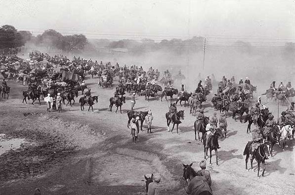
Author Rudyard Kipling described the road as "such a river of life as nowhere else exists in the entire world' He writes: "Look! Look again! and chumars, bankers and tinkers, barbers and bunnias, pilgrims -and potters - all the world going and coming. It is to me as a river from which I am withdrawn like a log after a flood. And truly the Grand Trunk Road is a wonderful spectacle. It runs straight, bearing without crowding India's traffic for fifteen hundred miles - such a river of life as nowhere else exists in the world."'".
Mughals extended Grand Trunk Road westwards. At one time, it extended to Kabul in Afghanistan, crossing the Khyber Pass. The road was later improved by the British rulers of colonial India. It was extended to run from Calcutta to Peshawar (present-day Pakistan). Over the centuries, the road acted as one of the major trade routes in the region and facilitated both travel and postal communication. Since the era of Sher Shah, the road was dotted with caravansarais at regular intervals, and trees were planted on both sides of the road to give shade to the travellers and merchants. Sher Shah made many roads for tax free trade. The Grand Trunk Road is still used for transportation in present-day India and Pakistan.