
- elevation 740 ft (226 m) - elevation 518 ft (158 m) Length 122 km Basin area 924.6 km² | - average 426 cu ft/s (12 m/s) Discharge 12.06 m³/s Basin area 924.6 km² | |
 | ||
- max 7,100 cu ft/s (201 m/s) | ||
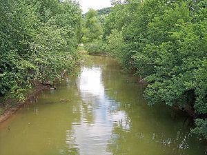
Symmes Creek is a 76.4-mile-long (123.0 km) tributary of the Ohio River in southern Ohio in the United States. Via the Ohio River, it is part of the watershed of the Mississippi River, draining an area of 357 square miles (920 km2) on the unglaciated portion of the Allegheny Plateau.
Contents
Map of Symmes Creek, Ohio, USA
Symmes Creek rises in Bloomfield Township in southeastern Jackson County and flows generally southward through Madison Township in Jackson County; Greenfield, Perry, and Walnut townships in Gallia County; and Symmes, Aid, Mason, Lawrence, Windsor, and Union townships in Lawrence County, through a portion of the Ironton Unit of the Wayne National Forest and past the communities of Waterloo, Aid, and Willow Wood. It joins the Ohio River at the village of Chesapeake, opposite downtown Huntington, West Virginia.
The United States Board on Geographic Names settled on "Symmes Creek" as the stream's name in 1902. According to the Geographic Names Information System, it has also been known historically as "Simms," "Big Creek," and "Symms Creek."
Flow rateEdit
At the United States Geological Survey's stream gauge in Aid, the annual mean flow of Symmes Creek between November 2000 and September 2005 was 426 ft³/s (12 m³/s). The highest recorded flow during the period was 7,100 ft³/s (201 m³/s) on May 19, 2001. The lowest recorded flow was 1 ft³/s (0 m³/s) on September 18, 2001.