
- elevation 1,568 ft (478 m) Length 686 km | - elevation 171 ft (52 m) Basin area 19,554 km² | |
 | ||
- left Little St. Francis River, Twelvemile Creek, Blue Spring, Mingo Ditch, Little River - location | ||
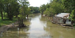
The Saint Francis River is a tributary of the Mississippi River, about 426 miles (686 km) long, in southeastern Missouri and northeastern Arkansas in the United States. The river drains a mostly rural area and forms part of the Missouri-Arkansas state line along the western side of the Missouri Bootheel.
Contents
- Map of St Francis River United States
- Description and courseEdit
- Whitewater paddling sectionsEdit
- River FlowsEdit
- Whitewater competitionsEdit
- NamesEdit
- References
Map of St Francis River, United States
Description and courseEdit
The river rises in a region of granite mountains in Iron County, Missouri, and flows generally southwardly through the Ozarks and the St. Francois Mountains near Missouri's highest point Taum Sauk. It forms the Missouri-Arkansas border in the Bootheel and eventually exits the state at Missouri's lowest point in the "toe" at 241 feet (73 m) above sea level. It passes through Lake Wappapello, which is formed by a dam constructed in 1941. Below the dam the river meanders through cane forests and willow swamplands, transitioning from a clear stream into a slow and silt-laden muddy river as it enters the flat lands of the Mississippi embayment. In its lower course the river parallels Crowleys Ridge and is part of a navigation and flood-control project involving a network of diversion channels and ditches along it and the Castor and Little Rivers. Below the mouth of the Little River in Poinsett County, Arkansas, the St. Francis is navigable by barge. It joins the Mississippi River in Phillips County, Arkansas, about 7 miles (11 km) north of Helena.
Along its course in Missouri the river flows through the Mark Twain National Forest and past Sam A. Baker State Park and the towns of Farmington, Greenville and Fisk. In Arkansas it passes the towns of St. Francis, Lake City, Marked Tree and Parkin, as well as the St. Francis National Forest.
In addition to the Little River, tributaries of the St. Francis include the Little St. Francis River, which joins it along its upper course in Missouri; the Tyronza River, which joins it in Arkansas; and the L'Anguille River, which joins it just above its mouth.
Whitewater paddling sectionsEdit
General overview and logistics:
The most popular section of the St. Francis river for whitewater boating is divided into two sections, the Upper and the lower. The Upper section's put in is near Fredericktown Missouri, off of HW 72 just after it crosses the river. The put is also located just upstream of where Stouts creek joins in with the St. Francis River. The take out for the upper St. Francis is at Millstream Gardens Conservation Area or slightly downstream of that at Tiemann Shut-ins which also serves at the usual put-in for the lower St. Francis. The total 5-mile stretch that encompasses both the upper and the Lower St. Francis River ends at Silver Mines Recreation Area (old highway D bridge).
Upper St. Francis:
The upper section of the river is much less technical than the lower and also has extensive flat water sections between rapids. The upper section is the longer of the two section at 3.2 miles. At the put-in for the upper section the water is very calm and is a great place for beginner paddlers to practice skills and rolling. Following the calm pool the river constricts slightly as it makes a large right turn and a great eddy line is formed to practice in. The first rapid encountered on the upper is Entrance Rapid. Entrance is a long, wide rapid with a series of ledges, steeper on the right, which provide good play waves for more technical boaters at lower levels. At flood levels, Entrance Rapid can be hazardous due to the willows growing along the sides and can present a challenge greater than the whitewater! The second rapid on the upper is Kitten’s Crossing and consists of a series of 3 drops with the third having a sizable surfing, wave/hole and a service eddy on the left. The final rapid for the upper is Land of Oz and has two back-to-back surfing waves on the left but the drop just below that collects wood and debris, so be cautious. (Land of Oz is named in honor of Oscar “Oz” Hawksley, an early exploratory paddler from Missouri and officer in the American Whitewater Affiliation.) After a several pools, the river makes a bend to the right before the take-out at Fisherman’s Access in Millstream Gardens Conservation Area.
Lower St. Francis:
The lower section is the much more exciting half of the river and contains the largest rapids, but is also the shorter section of the river at 2.3 miles in length. "This is Missouri's premier whitewater run. Probably 80% of the whitewater paddling in Missouri occurs on this section of the St. Francis River with the other 20% taking place either on the Upper St. Francis, on the whitewater creeks close to the St. Francis, on the Mississippi River Chain of Rocks at St. Louis, or at park-and-play spots around the state."
The put-in at (Tiemann Shut-ins) in Millstream Gardens Conservation Area, marks the beginning of a granite gorge with the river dropping 60 feet per mile. The whitewater action picks up immediately and continues through four major drops known as Big Drop, Cat's Paw, Double Drop, and Rickety-Rack. Throughout the lower St. Francis there are numerous play-spots with surfing waves/holes found everywhere. Downstream of Rickety-Rack, a high bluff can be seen on the right where Mud Creek enters on river right. The entrance of mud creek onto the Lower St. Francis is a good place to stretch you legs and take a small hike up the creek. The creek can be floated down at really high water, but an inner-tube would probably work best. After mud creek and a slow section, Turkey Creek enters on the left at Turkey Creek Picnic Area, part of the USFS Silver Mine Recreation Area. Following this the river bends to the right and is divided briefly by a forest of willow trees. This section contains some small happy white water and slightly higher levels can produce some small surfing waves. The left rout in the Willow jungle contains a small squeeze between two rocks. After the willows the river flows into a pool formed by the Silver Mines Dam, left over from long-ago mining activity. A breach blown in the left side of the dam provides a class II - II+ rapid at normal to moderate river levels. At higher levels when the river is near or over D bridge(6 ft), a dangerous hole forms, that just keeps getting bigger as the level rises. When the river is high enough for the entire dam to be covered (8 ft), the extremely hazardous pour-over is best if portaged around on river-right. When at lower levels, due to the large flat rocks bordering river left and the huge eddy one river right, the Dam is a very popular spot to stop and rest/eat/play. Downstream from the dam the only remaining rapids of note are Little Drop and Fat Man’s Squeeze. At levels below 5 ft, Little Drop makes for an amazing surfing hole/wave. The river continues fairly slow until the take-out at the low-water bridge in the USFS Silver Mines Recreation Area.
River FlowsEdit
Upper St. Francis
Lower St. Francis
Whitewater competitionsEdit
Since 1967 the Missouri Whitewater Championships have been held on the St. Francis River, typically between the Millstream Gardens Conservation Area and the Silver Mines Recreation Area. The events includes whitewater slalom competitions and downriver whitewater racing competitions. Today, the Missouri Whitewater Association holds the Championships annually in March, and recently celebrated the 40th year of Missouri Whitewater Championships on the St. Francis River.
NamesEdit
The origin of the river's name is unclear. It might refer to St. Francis of Assisi, the founder of the Franciscan order. None of the region's early explorers were Franciscans, however. One possibility is that Jacques Marquette, a Jesuit, named the river when he explored its mouth in 1673. Before his voyage down the Mississippi Marquette had spent some time at the mission of St. Francois Xavier, named for the Jesuit missionary Francis Xavier. The spelling of the river's name shifted from "François" to "Francis" in the early 20th century. A number of place names in the region stem from the river's name, including Saint Francois County and the St. Francois Mountains.
The United States Board on Geographic Names settled on "St. Francis River" as the stream's name in 1899. According to the Geographic Names Information System, historical names for the river have included: