
 | ||
Marqus clae south texas
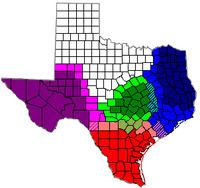
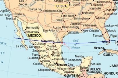
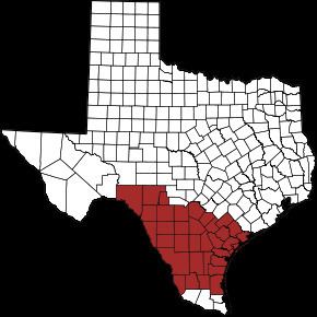
South Texas is a region of the U.S. state of Texas that lies roughly south of -- and sometimes including -- San Antonio. The southern and western boundary is the Rio Grande, and to the east it is the Gulf of Mexico. The population of this region is about 4.67 million according to the 2013 census estimates. The southern portion of this region is often referred to as the Rio Grande Valley. The eastern portion along the Gulf of Mexico is also referred to as the Coastal Bend. Many South Texas resident Exclude San Antonio, as San Antonio is southern Central Texas. Most consider the boundary being an imaginary line from Corpus Christi to Laredo and everything south of that with the three Counties in the Rio Grande Valley being known as Deep South Texas.
Contents
- Marqus clae south texas
- Oil men tales from the south texas oil patch hd
- Land
- Counties
- Cities
- Lakes and reservoirs
- Bays
- Estuaries and waterways
- Islands
- Climate
- Wildlife
- Sealife
- Multicultural influences
- Rice
- Air
- Passenger Rail
- Interstate
- US Routes
- Texas State Highways
- International Bridges
- Tourism
- Colleges
- Public universities
- Private universities
- Sports
- Area codes
- References
Oil men tales from the south texas oil patch hd
Land
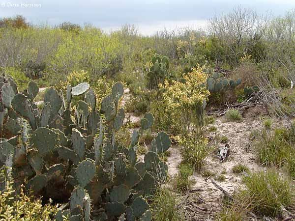
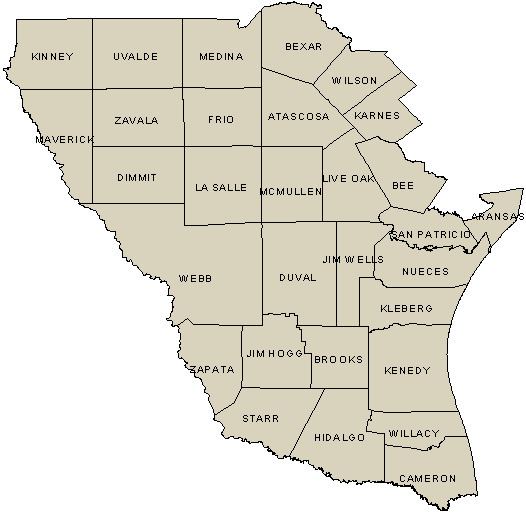
There is no defined northern boundary, although it is believed to be at the city of San Antonio and from an east to west line extending from the Rio Grande near Maverick County to the Gulf of Mexico, but turning southeast at or near Lavaca County, and continuing towards the Gulf of Mexico to separate it from East Texas and Southeast Texas. The Rio Grande serves as the western and southern boundaries and separates Texas from Mexico. The eastern portion of South Texas is bordered by the Gulf of Mexico. This region of Texas consist of 41 counties. South Texas terrain is flat, lying on the coastal plain. South Texas is so vast, there are even subregions. The very southern tip of South Texas, called the Rio Grande Valley, has fertile soils and is known for its citrus production. The eastern portion of South Texas is often referred to as the Coastal Bend; here, coastal salt marshes, estuaries, and wetlands are scattered. The western and central parts are known as the South Texas Plains or the brush country. Mesquite trees and crop fields dominate the land.
Counties
Cities
Some people consider Houston to be in South Texas for several reasons: Numerous businesses in the Houston region contain 'South Texas' in their titles. The United States District Court for the Southern District of Texas includes the Houston division. However, Houston is most accurately classified as being within Southeast Texas, a subregion of East Texas.
Lakes and reservoirs
Bays
Estuaries and waterways
Islands
Climate
The climate of South Texas is varied. The area along the Mexican border is generally semi-arid (Köppen climate classification Bsh), while the area from the coast inland to just west of San Antonio has a humid subtropical climate (Köppen Cfa). South Texas weather is affected by the Sierra Madre Oriental mountains to the west, the Gulf of Mexico to the east, and the Chihuahuan Desert to the west/northwest. Moisture from the Pacific is cut off by the Mexican Sierra Madre Occidental and Oriental mountain ranges. Along coastal south Texas, the climate is best exemplified in the summers because they are long and tropical, though at times arid, depending upon whether tropical moisture from the Gulf and sometimes from the Pacific is flowing in or if the region is cut off from any moisture by high pressure systems, causing long droughts, which occur every few years. Temperatures reach freezing only a few times in the winter and snowfall is rare, usually three inches or less. Summers in this zone are hot and humid, with daily averages above 90 °F (32 °C). In addition, areas in Texas that are slightly inland from the Gulf of Mexico, such as San Antonio that border the semi-arid climate zone, generally see a peak of precipitation in the spring, and a deep, drought-like nadir in midsummer. Night-time temperatures are around 85 °F in summer. The region of South Texas includes the semi-arid ranch country and the wetter Rio Grande Valley. Considered to be the southernmost tip of the American Great Plains region, the inland region has rainfall similar to that of the Northern Plains. The coastal areas are warm most of the year due to currents of the Gulf of Mexico, but can get cold in winter if a strong front comes in, occasionally causing snow at sea level. Rain in the coastal region is more abundant than in the inland region, and subtropical forests line the Rio Grande. Inland, where it is drier, ranches dominate the landscape, characterized by thick, spiny brush and grasslands. The winters in the inland region are cooler and drier, as Arctic air can make it into the region, but snow is rare due to the lack of humidity. Summers are for the most part hot and dry, but at times can be humid if winds come off the warmer Gulf of Mexico. Tornadoes can occur in this region, but less frequently than in other parts of the state.
Hurricanes are the most dangerous weather systems to affect South Texas. Hurricane season is between June and November. However, the Texas coast gets affected usually between August and September, when systems sporadically organize in the southern Gulf around the Bay of Campeche or western Caribbean and the latter months forming off the coast of Africa.
Droughts- Although South Texas summers generally see rainfall in summer months, some years the lack of rain is persistent and leads to water shortages; lake levels drop significantly and lead to municipal water restrictions. In the summer of 2011, numerous records were set. On August 28, 2011, most of South Texas had temperatures reaching 110 °F, breaking many cities' record highs. Furthermore, 95% of the state faced an extreme or exceptional drought, according to the office of the Texas state climatologist. These drought conditions led to a string of dangerous wildfires across the state, and the enforcement of burn bans in 250 of the 254 counties in Texas.
Tornadoes do occur in this part of the state, but not as frequently as other parts. They approach, usually from the northwest to southeast, as a line of severe thunderstorms, mostly in the summer months and by cold fronts in fall.
Snow rarely falls south of San Antonio or on the coast except in rare circumstances. Of note is the 2004 Christmas Eve snowstorm, when 6 inches (150 mm) of snow fell as far south as McAllen.
Wildlife
(incomplete list)
Sealife
Multicultural influences
South Texas is well known for strong Hispanic, primarily Mexican American and Tejano (the Spanish term for "Texan") influences, due to its proximity to Mexico. Tejanos and Mexicans living in South Texas are descended from the Spanish and Sephardic Jewish settlers of Mexico, from Mexican indigenous groups allied with the Spanish, such as Tlaxcaltec and Otomi peoples, and from local indigenous groups of South Texas who were missionized by the Spanish, particularly Coahuiltecans. These migrations occurred and have been ongoing since the early 1700s in South Texas. The Treaty of Guadalupe Hidalgo in the 1840s failed to secure land belonging to the Mexican settlers. The disputed area was between the Nueces River south of San Antonio and Corpus Christi, the King Ranch, and the Rio Grande. Recognized by neither Mexico nor the United States, the Republic of the Rio Grande was established in this region in 1840, lasting less than a year. Laredo served as its capital.
The Rio Grande Valley area played a significant role in the Mexican War of Independence, the Texas Revolution, the Mexican–American War, and the American Civil War, with many historical battle sites around the area. General Robert E. Lee resided at Fort Ringold (Rio Grande City) during this time as a colonel. President Zachary Taylor was General of the Army at Fort Brown (Brownsville) during the Mexican–American War.
The Texas Rangers gained popularity for their actions in South Texas during the Mexican bandit raids in the late 19th and early 20th centuries. On May 25, 1876, a band of 40 Texas Rangers rode out of Laredo and headed north to the infamous Nueces Strip. Their mission was to find, kill or capture John King Fisher, leader of a band of cattle rustlers and cut-throats who had been terrorizing the area. The Rangers were members of a select group known as the Special Force. Led by the legendary Leander McNelly, the Special Force was given the task to bring law and order to an area of South Texas that lay between Corpus Christi and the Mexican border.
Rice
An important event in the development of South Texas and the Texas Gulf Coast rice industry was the introduction of seed imported from Japan in 1904. The Houston Chamber of Commerce and the Southern Pacific Railroad invited Japanese farmers to Texas to help area farms in the production of rice. The seed the Japanese farmers brought with them was a gift from the Japanese emperor. The production of Japanese rice began at Webster in Harris County. The Gulf Coast rice industry is credited to the Saibara family.
Air
Passenger Rail
Interstate
US Routes
Texas State Highways
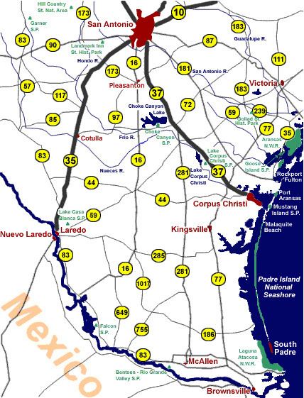
International Bridges
Laredo
Eagle Pass
Brownsville
Los Indios
Falcon Heights
Hidalgo
McAllen
Pharr
Progreso
Rio Grande City
Roma
Tourism
San Antonio
Corpus Christi
Laredo
Rio Grande Valley
Other
Colleges
Public universities
Private universities
Sports
The only major professional sports team in South Texas is the San Antonio Spurs in the NBA.