
 | ||
Should we control wildfires
A wildfire or wildland fire is a fire in an area of combustible vegetation that occurs in the countryside or rural area. Depending on the type of vegetation where it occurs, a wildfire can also be classified more specifically as a brush fire, bush fire, desert fire, forest fire, grass fire, hill fire, peat fire, vegetation fire, or veld fire. Fossil charcoal indicates that wildfires began soon after the appearance of terrestrial plants 420 million years ago. Wildfire’s occurrence throughout the history of terrestrial life invites conjecture that fire must have had pronounced evolutionary effects on most ecosystems' flora and fauna. Earth is an intrinsically flammable planet owing to its cover of carbon-rich vegetation, seasonally dry climates, atmospheric oxygen, and widespread lightning and volcano ignitions.
Contents
- Should we control wildfires
- Fort mcmurray wildfire a timeline of a disaster
- Causes
- Spread
- Effect of weather
- Ecology
- Plant adaptation
- Atmospheric effects
- History
- Human involvement
- Prevention
- History of wildfire policy in the US
- Wildland urban interface policy
- Economics of fire management policy
- Detection
- Suppression
- Costs of wildfire suppression
- Wildland firefighting safety
- Fire retardant
- Modeling
- Human risk and exposure
- Regional burden of wildfires in the United States
- Chemical hazards
- Groups at risk
- Health effects
- Epidemiology
- Notable wildfires
- References
Wildfires can be characterized in terms of the cause of ignition, their physical properties, the combustible material present, and the effect of weather on the fire. Wildfires can cause damage to property and human life, but they have many beneficial effects on native vegetation, animals, and ecosystems that have evolved with fire. Many plant species depend on the effects of fire for growth and reproduction. However, wildfire in ecosystems where wildfire is uncommon or where non-native vegetation has encroached may have negative ecological effects. Wildfire behaviour and severity result from the combination of factors such as available fuels, physical setting, and weather. Analyses of historical meteorological data and national fire records in western North America show the primacy of climate in driving large regional fires via wet periods that create substantial fuels or drought and warming that extend conducive fire weather.
Strategies of wildfire prevention, detection, and suppression have varied over the years. One common and inexpensive technique is controlled burning: permitting or even igniting smaller fires to minimize the amount of flammable material available for a potential wildfire. Vegetation may be burned periodically to maintain high species diversity and frequent burning of surface fuels limits fuel accumulation. Wildland fire use is the cheapest and most ecologically appropriate policy for many forests. Fuels may also be removed by logging, but fuels treatments and thinning have no effect on severe fire behavior. Wildfire itself is reportedly "the most effective treatment for reducing a fire's rate of spread, fireline intensity, flame length, and heat per unit of area" according to Jan Van Wagtendonk, a biologist at the Yellowstone Field Station. Building codes in fire-prone areas typically require that structures be built of flame-resistant materials and a defensible space be maintained by clearing flammable materials within a prescribed distance from the structure.
Fort mcmurray wildfire a timeline of a disaster
Causes
Four major natural causes of wildfire ignitions exist:

The most common direct human causes of wildfire ignition include arson, discarded cigarettes, power-line arcs (as detected by arc mapping), and sparks from equipment Ignition of wildland fires via contact with hot rifle-bullet fragments is also possible under the right conditions. Wildfires can also be started in communities experiencing shifting cultivation, where land is cleared quickly and farmed until the soil loses fertility, and slash and burn clearing. Forested areas cleared by logging encourage the dominance of flammable grasses, and abandoned logging roads overgrown by vegetation may act as fire corridors. Annual grassland fires in southern Vietnam stem in part from the destruction of forested areas by US military herbicides, explosives, and mechanical land-clearing and -burning operations during the Vietnam War.

The most common cause of wildfires varies throughout the world. In Canada and northwest China, for example, lightning operates as the major source of ignition. In other parts of the world, human involvement is a major contributor. In Africa, Central America, Fiji, Mexico, New Zealand, South America, and Southeast Asia, wildfires can be attributed to human activities such as agriculture, animal husbandry, and land-conversion burning. In China and in the Mediterranean Basin, human carelessness is a major cause of wildfires. In the United States and Australia, the source of wildfires can be traced both to lightning strikes and to human activities (such as machinery sparks, cast-away cigarette butts, or arson)." Coal seam fires burn in the thousands around the world, such as those in Burning Mountain, New South Wales; Centralia, Pennsylvania; and several coal-sustained fires in China. They can also flare up unexpectedly and ignite nearby flammable material.
Spread
The spread of wildfires varies based on the flammable material present, its vertical arrangement and moisture content, and weather conditions. Fuel arrangement and density is governed in part by topography, as land shape determines factors such as available sunlight and water for plant growth. Overall, fire types can be generally characterized by their fuels as follows:
Wildfires occur when all of the necessary elements of a fire triangle come together in a susceptible area: an ignition source is brought into contact with a combustible material such as vegetation, that is subjected to sufficient heat and has an adequate supply of oxygen from the ambient air. A high moisture content usually prevents ignition and slows propagation, because higher temperatures are required to evaporate any water within the material and heat the material to its fire point. Dense forests usually provide more shade, resulting in lower ambient temperatures and greater humidity, and are therefore less susceptible to wildfires. Less dense material such as grasses and leaves are easier to ignite because they contain less water than denser material such as branches and trunks. Plants continuously lose water by evapotranspiration, but water loss is usually balanced by water absorbed from the soil, humidity, or rain. When this balance is not maintained, plants dry out and are therefore more flammable, often a consequence of droughts.
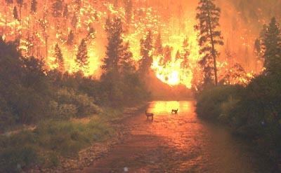
A wildfire front is the portion sustaining continuous flaming combustion, where unburned material meets active flames, or the smoldering transition between unburned and burned material. As the front approaches, the fire heats both the surrounding air and woody material through convection and thermal radiation. First, wood is dried as water is vaporized at a temperature of 100 °C (212 °F). Next, the pyrolysis of wood at 230 °C (450 °F) releases flammable gases. Finally, wood can smoulder at 380 °C (720 °F) or, when heated sufficiently, ignite at 590 °C (1,000 °F). Even before the flames of a wildfire arrive at a particular location, heat transfer from the wildfire front warms the air to 800 °C (1,470 °F), which pre-heats and dries flammable materials, causing materials to ignite faster and allowing the fire to spread faster. High-temperature and long-duration surface wildfires may encourage flashover or torching: the drying of tree canopies and their subsequent ignition from below.
Wildfires have a rapid forward rate of spread (FROS) when burning through dense, uninterrupted fuels. They can move as fast as 10.8 kilometres per hour (6.7 mph) in forests and 22 kilometres per hour (14 mph) in grasslands. Wildfires can advance tangential to the main front to form a flanking front, or burn in the opposite direction of the main front by backing. They may also spread by jumping or spotting as winds and vertical convection columns carry firebrands (hot wood embers) and other burning materials through the air over roads, rivers, and other barriers that may otherwise act as firebreaks. Torching and fires in tree canopies encourage spotting, and dry ground fuels that surround a wildfire are especially vulnerable to ignition from firebrands. Spotting can create spot fires as hot embers and firebrands ignite fuels downwind from the fire. In Australian bushfires, spot fires are known to occur as far as 20 kilometres (12 mi) from the fire front.
Especially large wildfires may affect air currents in their immediate vicinities by the stack effect: air rises as it is heated, and large wildfires create powerful updrafts that will draw in new, cooler air from surrounding areas in thermal columns. Great vertical differences in temperature and humidity encourage pyrocumulus clouds, strong winds, and fire whirls with the force of tornadoes at speeds of more than 80 kilometres per hour (50 mph). Rapid rates of spread, prolific crowning or spotting, the presence of fire whirls, and strong convection columns signify extreme conditions.
The thermal heat from wildfire can cause significant weathering of rocks and boulders, heat can rapidly expand a boulder and thermal shock can occur, which may cause an object's structure to fail.
Effect of weather
Heat waves, droughts, cyclical climate changes such as El Niño, and regional weather patterns such as high-pressure ridges can increase the risk and alter the behavior of wildfires dramatically. Years of precipitation followed by warm periods can encourage more widespread fires and longer fire seasons. Since the mid-1980s, earlier snowmelt and associated warming has also been associated with an increase in length and severity of the wildfire season in the Western United States. Global warming may increase the intensity and frequency of droughts in many areas, creating more intense and frequent wildfires. A 2015 study indicates that the increase in fire risk in California may be attributable to human-induced climate change. A study of alluvial sediment deposits going back over 8,000 years found warmer climate periods experienced severe droughts and stand-replacing fires and concluded climate was such a powerful influence on wildfire that trying to recreate presettlement forest structure is likely impossible in a warmer future.
Intensity also increases during daytime hours. Burn rates of smoldering logs are up to five times greater during the day due to lower humidity, increased temperatures, and increased wind speeds. Sunlight warms the ground during the day which creates air currents that travel uphill. At night the land cools, creating air currents that travel downhill. Wildfires are fanned by these winds and often follow the air currents over hills and through valleys. Fires in Europe occur frequently during the hours of 12:00 p.m. and 2:00 p.m. Wildfire suppression operations in the United States revolve around a 24-hour fire day that begins at 10:00 a.m. due to the predictable increase in intensity resulting from the daytime warmth.
Ecology
Wildfire’s occurrence throughout the history of terrestrial life invites conjecture that fire must have had pronounced evolutionary effects on most ecosystems' flora and fauna. Wildfires are common in climates that are sufficiently moist to allow the growth of vegetation but feature extended dry, hot periods. Such places include the vegetated areas of Australia and Southeast Asia, the veld in southern Africa, the fynbos in the Western Cape of South Africa, the forested areas of the United States and Canada, and the Mediterranean Basin.
High-severity wildfire creates complex early seral forest habitat (also called “snag forest habitat”), which often has higher species richness and diversity than unburned old forest. Plant and animal species in most types of North American forests evolved with fire, and many of these species depend on wildfires, and particularly high-severity fires, to reproduce and grow. Fire helps to return nutrients from plant matter back to soil, the heat from fire is necessary to the germination of certain types of seeds, and the snags (dead trees) and early successional forests created by high-severity fire create habitat conditions that are beneficial to wildlife. Early successional forests created by high-severity fire support some of the highest levels of native biodiversity found in temperate conifer forests. Post-fire logging has no ecological benefits and many negative impacts; the same is often true for post-fire seeding.
Although some ecosystems rely on naturally occurring fires to regulate growth, some ecosystems suffer from too much fire, such as the chaparral in southern California and lower elevation deserts in the American Southwest. The increased fire frequency in these ordinarily fire-dependent areas has upset natural cycles, damaged native plant communities, and encouraged the growth of non-native weeds. Invasive species, such as Lygodium microphyllum and Bromus tectorum, can grow rapidly in areas that were damaged by fires. Because they are highly flammable, they can increase the future risk of fire, creating a positive feedback loop that increases fire frequency and further alters native vegetation communities.
In the Amazon Rainforest, drought, logging, cattle ranching practices, and slash-and-burn agriculture damage fire-resistant forests and promote the growth of flammable brush, creating a cycle that encourages more burning. Fires in the rainforest threaten its collection of diverse species and produce large amounts of CO2. Also, fires in the rainforest, along with drought and human involvement, could damage or destroy more than half of the Amazon rainforest by the year 2030. Wildfires generate ash, destroy available organic nutrients, and cause an increase in water runoff, eroding away other nutrients and creating flash flood conditions. A 2003 wildfire in the North Yorkshire Moors destroyed 2.5 square kilometers (600 acres) of heather and the underlying peat layers. Afterwards, wind erosion stripped the ash and the exposed soil, revealing archaeological remains dating back to 10,000 BC. Wildfires can also have an effect on climate change, increasing the amount of carbon released into the atmosphere and inhibiting vegetation growth, which affects overall carbon uptake by plants.
In tundra there is a natural pattern of accumulation of fuel and wildfire which varies depending on the nature of vegetation and terrain. Research in Alaska has shown fire-event return intervals, (FRIs) that typically vary from 150 to 200 years with dryer lowland areas burning more frequently than wetter upland areas.
Plant adaptation
Plants in wildfire-prone ecosystems often survive through adaptations to their local fire regime. Such adaptations include physical protection against heat, increased growth after a fire event, and flammable materials that encourage fire and may eliminate competition. For example, plants of the genus Eucalyptus contain flammable oils that encourage fire and hard sclerophyll leaves to resist heat and drought, ensuring their dominance over less fire-tolerant species. Dense bark, shedding lower branches, and high water content in external structures may also protect trees from rising temperatures. Fire-resistant seeds and reserve shoots that sprout after a fire encourage species preservation, as embodied by pioneer species. Smoke, charred wood, and heat can stimulate the germination of seeds in a process called serotiny. Exposure to smoke from burning plants promotes germination in other types of plants by inducing the production of the orange butenolide.
Grasslands in Western Sabah, Malaysian pine forests, and Indonesian Casuarina forests are believed to have resulted from previous periods of fire. Chamise deadwood litter is low in water content and flammable, and the shrub quickly sprouts after a fire. Cape lilies lie dormant until flames brush away the covering, then blossom almost overnight. Sequoia rely on periodic fires to reduce competition, release seeds from their cones, and clear the soil and canopy for new growth. Caribbean Pine in Bahamian pineyards have adapted to and rely on low-intensity, surface fires for survival and growth. An optimum fire frequency for growth is every 3 to 10 years. Too frequent fires favor herbaceous plants, and infrequent fires favor species typical of Bahamian dry forests.
Atmospheric effects
Most of the Earth's weather and air pollution resides in the troposphere, the part of the atmosphere that extends from the surface of the planet to a height of about 10 kilometers (6 mi). The vertical lift of a severe thunderstorm or pyrocumulonimbus can be enhanced in the area of a large wildfire, which can propel smoke, soot, and other particulate matter as high as the lower stratosphere. Previously, prevailing scientific theory held that most particles in the stratosphere came from volcanoes, but smoke and other wildfire emissions have been detected from the lower stratosphere. Pyrocumulus clouds can reach 6,100 meters (20,000 ft) over wildfires. Satellite observation of smoke plumes from wildfires revealed that the plumes could be traced intact for distances exceeding 1,600 kilometers (1,000 mi). Computer-aided models such as CALPUFF may help predict the size and direction of wildfire-generated smoke plumes by using atmospheric dispersion modeling.
Wildfires can affect local atmospheric pollution, and release carbon in the form of carbon dioxide. Wildfire emissions contain fine particulate matter which can cause cardiovascular and respiratory problems. Increased fire byproducts in the troposphere can increase ozone concentration beyond safe levels. Forest fires in Indonesia in 1997 were estimated to have released between 0.81 and 2.57 gigatonnes (0.89 and 2.83 billion short tons) of CO2 into the atmosphere, which is between 13%–40% of the annual global carbon dioxide emissions from burning fossil fuels. Atmospheric models suggest that these concentrations of sooty particles could increase absorption of incoming solar radiation during winter months by as much as 15%.
History
In the Welsh Borders, the first evidence of wildfire is rhyniophytoid plant fossils preserved as charcoal, dating to the Silurian period (about 420 million years ago). Smoldering surface fires started to occur sometime before the Early Devonian period 405 million years ago. Low atmospheric oxygen during the Middle and Late Devonian was accompanied by a decrease in charcoal abundance. Additional charcoal evidence suggests that fires continued through the Carboniferous period. Later, the overall increase of atmospheric oxygen from 13% in the Late Devonian to 30-31% by the Late Permian was accompanied by a more widespread distribution of wildfires. Later, a decrease in wildfire-related charcoal deposits from the late Permian to the Triassic periods is explained by a decrease in oxygen levels.
Wildfires during the Paleozoic and Mesozoic periods followed patterns similar to fires that occur in modern times. Surface fires driven by dry seasons are evident in Devonian and Carboniferous progymnosperm forests. Lepidodendron forests dating to the Carboniferous period have charred peaks, evidence of crown fires. In Jurassic gymnosperm forests, there is evidence of high frequency, light surface fires. The increase of fire activity in the late Tertiary is possibly due to the increase of C4-type grasses. As these grasses shifted to more mesic habitats, their high flammability increased fire frequency, promoting grasslands over woodlands. However, fire-prone habitats may have contributed to the prominence of trees such as those of the genera Eucalyptus, Pinus and Sequoia, which have thick bark to withstand fires and employ serotiny.
Human involvement
The human use of fire for agricultural and hunting purposes during the Paleolithic and Mesolithic ages altered the preexisting landscapes and fire regimes. Woodlands were gradually replaced by smaller vegetation that facilitated travel, hunting, seed-gathering and planting. In recorded human history, minor allusions to wildfires were mentioned in the Bible and by classical writers such as Homer. However, while ancient Hebrew, Greek, and Roman writers were aware of fires, they were not very interested in the uncultivated lands where wildfires occurred. Wildfires were used in battles throughout human history as early thermal weapons. From the Middle ages, accounts were written of occupational burning as well as customs and laws that governed the use of fire. In Germany, regular burning was documented in 1290 in the Odenwald and in 1344 in the Black Forest. In the 14th century Sardinia, firebreaks were used for wildfire protection. In Spain during the 1550s, sheep husbandry was discouraged in certain provinces by Philip II due to the harmful effects of fires used in transhumance. As early as the 17th century, Native Americans were observed using fire for many purposes including cultivation, signaling, and warfare. Scottish botanist David Douglas noted the native use of fire for tobacco cultivation, to encourage deer into smaller areas for hunting purposes, and to improve foraging for honey and grasshoppers. Charcoal found in sedimentary deposits off the Pacific coast of Central America suggests that more burning occurred in the 50 years before the Spanish colonization of the Americas than after the colonization. In the post-World War II Baltic region, socio-economic changes led more stringent air quality standards and bans on fires that eliminated traditional burning practices. In the mid-19th century, explorers from the HMS Beagle observed Australian Aborigines using fire for ground clearing, hunting, and regeneration of plant food in a method later named fire-stick farming. Such careful use of fire has been employed for centuries in the lands protected by Kakadu National Park to encourage biodiversity.
Wildfires typically occurred during periods of increased temperature and drought. An increase in fire-related debris flow in alluvial fans of northeastern Yellowstone National Park was linked to the period between AD 1050 and 1200, coinciding with the Medieval Warm Period. However, human influence caused an increase in fire frequency. Dendrochronological fire scar data and charcoal layer data in Finland suggests that, while many fires occurred during severe drought conditions, an increase in the number of fires during 850 BC and 1660 AD can be attributed to human influence. Charcoal evidence from the Americas suggested a general decrease in wildfires between 1 AD and 1750 compared to previous years. However, a period of increased fire frequency between 1750 and 1870 was suggested by charcoal data from North America and Asia, attributed to human population growth and influences such as land clearing practices. This period was followed by an overall decrease in burning in the 20th century, linked to the expansion of agriculture, increased livestock grazing, and fire prevention efforts. A meta-analysis found that 17 times more land burned annually in California before 1800 compared to recent decades (1,800,000 hectares/year compared to 102,000 hectares/year).
Invasive species moved by humans have in some cases increased the intensity of wildfires, such as Eucalyptus in California and gamba grass in Australia.
Prevention
Wildfire prevention refers to the preemptive methods aimed at reducing the risk of fires as well as lessening its severity and spread. Prevention techniques aim to manage air quality, maintain ecological balances, protect resources, and to affect future fires. North American firefighting policies permit naturally caused fires to burn to maintain their ecological role, so long as the risks of escape into high-value areas are mitigated. However, prevention policies must consider the role that humans play in wildfires, since, for example, 95% of forest fires in Europe are related to human involvement. Sources of human-caused fire may include arson, accidental ignition, or the uncontrolled use of fire in land-clearing and agriculture such as the slash-and-burn farming in Southeast Asia.
In 1937, U.S. President Franklin D. Roosevelt initiated a nationwide fire prevention campaign, highlighting the role of human carelessness in forest fires. Later posters of the program featured Uncle Sam, leaders of the Axis powers of World War II, characters from the Disney movie Bambi, and the official mascot of the U.S. Forest Service, Smokey Bear. Reducing human-caused ignitions may be the most effective means of reducing unwanted wildfire. Alteration of fuels is commonly undertaken when attempting to affect future fire risk and behavior. Wildfire prevention programs around the world may employ techniques such as wildland fire use and prescribed or controlled burns. Wildland fire use refers to any fire of natural causes that is monitored but allowed to burn. Controlled burns are fires ignited by government agencies under less dangerous weather conditions.
Vegetation may be burned periodically to maintain high species diversity and frequent burning of surface fuels limits fuel accumulation. Wildland fire use is the cheapest and most ecologically appropriate policy for many forests. Fuels may also be removed by logging, but fuels treatments and thinning have no effect on severe fire behavior Wildfire models are often used to predict and compare the benefits of different fuel treatments on future wildfire spread, but their accuracy is low.
Wildfire itself is reportedly "the most effective treatment for reducing a fire's rate of spread, fireline intensity, flame length, and heat per unit of area" according to Jan Van Wagtendonk, a biologist at the Yellowstone Field Station.
Building codes in fire-prone areas typically require that structures be built of flame-resistant materials and a defensible space be maintained by clearing flammable materials within a prescribed distance from the structure. Communities in the Philippines also maintain fire lines 5 to 10 meters (16 to 33 ft) wide between the forest and their village, and patrol these lines during summer months or seasons of dry weather. Continued residential development in fire-prone areas and rebuilding structures destroyed by fires has been met with criticism. The ecological benefits of fire are often overridden by the economic and safety benefits of protecting structures and human life.
History of wildfire policy in the U.S.
Since the turn of the 20th century, various federal and state agencies have been involved in wildland fire management in one form or another. In the early 20th century, for example, the federal government, through the U.S. Army and the U.S. Forest Service, solicited fire suppression as a primary goal of managing the nation's forests. At this time in history fire was viewed as a threat to timber, an economically important natural resource. As such, the decision was made to devote public funds to fire suppression and fire prevention efforts. For example, the Forest Fire Emergency Fund Act of 1908 permitted deficit spending in the case of emergency fire situations. As a result, the U.S. Forest Service was able to acquire a deficit of over $1 million in 1910 due to emergency fire suppression efforts. Following the same tone of timber resource protection, the U.S. Forest Service adopted the "10 AM Policy" in 1935. Through this policy, the agency advocated the control of all fires by 10 o'clock of the morning following the discovery of a wildfire. Fire prevention was also heavily advocated through public education campaigns such as Smokey Bear. Through these and similar public education campaigns the general public was, in a sense, trained to perceive all wildfire as a threat to civilized society and natural resources. The negative sentiment towards wildland fire prevailed and helped to shape wildland fire management objectives throughout most of the 20th century.
Beginning in the 1970s public perception of wildland fire management began to shift. Despite strong funding for fire suppression in the first half of the 20th century, massive wildfires continued to be prevalent across the landscape of North America. Ecologists were beginning to recognize the presence and ecological importance of natural, lightning-ignited wildfires across the United States. It was learned that suppression of fire in certain ecosystems may in fact increase the likelihood that a wildfire will occur and may increase the intensity of those wildfires. With the emergence of fire ecology as a science also came an effort to apply fire to ecosystems in a controlled manner; however, suppression is still the main tactic when a fire is set by a human or if it threatens life or property. By the 1980s, in light of this new understanding, funding efforts began to support prescribed burning in order to prevent wildfire events. In 2001, the United States implemented a National Fire Plan, increasing the budget for the reduction of hazardous fuels from $108 million in 2000 to $401 million.
In addition to using prescribed fire to reduce the chance of catastrophic wildfires, mechanical methods have recently been adopted as well. Mechanical methods include the use of chippers and other machinery to remove hazardous fuels and thereby reduce the risk of wildfire events. Today the United States' maintains that, "fire, as a critical natural process, will be integrated into land and resource management plans and activities on a landscape scale, and across agency boundaries. Response to wildfire is based on ecological, social and legal consequences of fire. The circumstance under which a fire occurs, and the likely consequences and public safety and welfare, natural and cultural resources, and values to be protected dictate the appropriate management response to fire" (United States Department of Agriculture Guidance for Implementation of Federal Wildland Fire Management Policy, 13 February 2009). The five federal regulatory agencies managing forest fire response and planning for 676 million acres in the United States are the Department of the Interior, the Bureau of Land Management, the Bureau of Indian Affairs, the National Park Service, the United States Department of Agriculture-Forest Service and the United States Fish and Wildlife Services. Several hundred million U.S. acres of wildfire management are also conducted by state, county, and local fire management organizations. In 2014, legislators proposed The Wildfire Disaster Funding Act to provide $2.7 billion fund appropriated by congress for the USDA and Department of Interior to use in fire suppression. The bill is a reaction to United States Forest Service and Department of Interior costs of Western Wildfire suppression appending that amounted to $3.5 billion in 2013.
Wildland-urban interface policy
An aspect of wildfire policy that is gaining attention is the wildland-urban interface (WUI). More and more people are living in "red zones," or areas that are at high risk of wildfires. FEMA and the NFPA develop specific policies to guide homeowners and builders in how to build and maintain structures at the WUI and how protect against property losses. For example, NFPA-1141 is a standard for fire protection infrastructure for land development in wildland, rural and suburban areas and NFPA-1144 is a standard for reducing structure ignition hazards from wildland fire. For a full list of these policies and guidelines, see http://www.nfpa.org/categoryList.asp?categoryID=124&URL=Codes%20&%20Standards. Compensation for losses in the WUI are typically negotiated on an incident-by-incident basis. This is generating discussion about the burden of responsibility for funding and fighting a fire in the WUI, in that, if a resident chooses to live in a known red zone, should he or she retain a higher level of responsibility for funding home protection against wildfires. One initiative aimed at helping U.S. WUI communities live more safely with fire is called fire-adapted communities.
Economics of fire management policy
Similar to that of military operations, fire management is often very expensive in the U.S. and the rest of the world. Today, it is not uncommon for suppression operations for a single wildfire to exceed costs of $1 million in just a few days. The United States Department of Agriculture allotted $2.2 billion for wildfire management in 2012. Although fire suppression purports to benefit society, other options for fire management exist. While these options cannot completely replace fire suppression as a fire management tool, other options can play an important role in overall fire management and can therefore affect the costs of fire suppression.
It is commonly accepted that past fire suppression and climate change has resulted in larger, more intense wildfire events which are seen today. In economic terms, expenditures used for wildfire suppression in the early 20th century have contributed to increased suppression costs which are being realized today.
Detection
Fast and effective detection is a key factor in wildfire fighting. Early detection efforts were focused on early response, accurate results in both daytime and nighttime, and the ability to prioritize fire danger. Fire lookout towers were used in the United States in the early 20th century and fires were reported using telephones, carrier pigeons, and heliographs. Aerial and land photography using instant cameras were used in the 1950s until infrared scanning was developed for fire detection in the 1960s. However, information analysis and delivery was often delayed by limitations in communication technology. Early satellite-derived fire analyses were hand-drawn on maps at a remote site and sent via overnight mail to the fire manager. During the Yellowstone fires of 1988, a data station was established in West Yellowstone, permitting the delivery of satellite-based fire information in approximately four hours.
Currently, public hotlines, fire lookouts in towers, and ground and aerial patrols can be used as a means of early detection of forest fires. However, accurate human observation may be limited by operator fatigue, time of day, time of year, and geographic location. Electronic systems have gained popularity in recent years as a possible resolution to human operator error. A government report on a recent trial of three automated camera fire detection systems in Australia did, however, conclude "...detection by the camera systems was slower and less reliable than by a trained human observer". These systems may be semi- or fully automated and employ systems based on the risk area and degree of human presence, as suggested by GIS data analyses. An integrated approach of multiple systems can be used to merge satellite data, aerial imagery, and personnel position via Global Positioning System (GPS) into a collective whole for near-realtime use by wireless Incident Command Centers.
A small, high risk area that features thick vegetation, a strong human presence, or is close to a critical urban area can be monitored using a local sensor network. Detection systems may include wireless sensor networks that act as automated weather systems: detecting temperature, humidity, and smoke. These may be battery-powered, solar-powered, or tree-rechargeable: able to recharge their battery systems using the small electrical currents in plant material. Larger, medium-risk areas can be monitored by scanning towers that incorporate fixed cameras and sensors to detect smoke or additional factors such as the infrared signature of carbon dioxide produced by fires. Additional capabilities such as night vision, brightness detection, and color change detection may also be incorporated into sensor arrays.
Satellite and aerial monitoring through the use of planes, helicopter, or UAVs can provide a wider view and may be sufficient to monitor very large, low risk areas. These more sophisticated systems employ GPS and aircraft-mounted infrared or high-resolution visible cameras to identify and target wildfires. Satellite-mounted sensors such as Envisat's Advanced Along Track Scanning Radiometer and European Remote-Sensing Satellite's Along-Track Scanning Radiometer can measure infrared radiation emitted by fires, identifying hot spots greater than 39 °C (102 °F). The National Oceanic and Atmospheric Administration's Hazard Mapping System combines remote-sensing data from satellite sources such as Geostationary Operational Environmental Satellite (GOES), Moderate-Resolution Imaging Spectroradiometer (MODIS), and Advanced Very High Resolution Radiometer (AVHRR) for detection of fire and smoke plume locations. However, satellite detection is prone to offset errors, anywhere from 2 to 3 kilometers (1 to 2 mi) for MODIS and AVHRR data and up to 12 kilometers (7.5 mi) for GOES data. Satellites in geostationary orbits may become disabled, and satellites in polar orbits are often limited by their short window of observation time. Cloud cover and image resolution and may also limit the effectiveness of satellite imagery.
in 2015 a new fire detection tool is in operation at the U.S. Department of Agriculture (USDA) Forest Service (USFS) which uses data from the Suomi National Polar-orbiting Partnership (NPP) satellite to detect smaller fires in more detail than previous space-based products. The high-resolution data is used with a computer model to predict how a fire will change direction based on weather and land conditions. The active fire detection product using data from Suomi NPP's Visible Infrared Imaging Radiometer Suite (VIIRS) increases the resolution of fire observations to 1,230 feet (375 meters). Previous NASA satellite data products available since the early 2000s observed fires at 3,280 foot (1 kilometer) resolution. The data is one of the intelligence tools used by the USFS and Department of Interior agencies across the United States to guide resource allocation and strategic fire management decisions. The enhanced VIIRS fire product enables detection every 12 hours or less of much smaller fires and provides more detail and consistent tracking of fire lines during long duration wildfires – capabilities critical for early warning systems and support of routine mapping of fire progression. Active fire locations are available to users within minutes from the satellite overpass through data processing facilities at the USFS Remote Sensing Applications Center, which uses technologies developed by the NASA Goddard Space Flight Center Direct Readout Laboratory in Greenbelt, Maryland. The model uses data on weather conditions and the land surrounding an active fire to predict 12–18 hours in advance whether a blaze will shift direction. The state of Colorado decided to incorporate the weather-fire model in its firefighting efforts beginning with the 2016 fire season.
In 2014, an international campaign was organized in South Africa's Kruger National Park to validate fire detection products including the new VIIRS active fire data. In advance of that campaign, the Meraka Institute of the Council for Scientific and Industrial Research in Pretoria, South Africa, an early adopter of the VIIRS 375m fire product, put it to use during several large wildfires in Kruger.
The demand for timely, high-quality fire information has increased in recent years. Wildfires in the United States burn an average of 7 million acres of land each year. For the last 10 years, the USFS and Department of Interior have spent a combined average of about $2–4 billion annually on wildfire suppression.
Suppression
Wildfire suppression depends on the technologies available in the area in which the wildfire occurs. In less developed nations the techniques used can be as simple as throwing sand or beating the fire with sticks or palm fronds. In more advanced nations, the suppression methods vary due to increased technological capacity. Silver iodide can be used to encourage snow fall, while fire retardants and water can be dropped onto fires by unmanned aerial vehicles, planes, and helicopters. Complete fire suppression is no longer an expectation, but the majority of wildfires are often extinguished before they grow out of control. While more than 99% of the 10,000 new wildfires each year are contained, escaped wildfires under extreme weather conditions are difficult to suppress without a change in the weather. Wildfires in Canada and the US burn an average of 54,500 square kilometers (13,000,000 acres) per year.
Above all, fighting wildfires can become deadly. A wildfire's burning front may also change direction unexpectedly and jump across fire breaks. Intense heat and smoke can lead to disorientation and loss of appreciation of the direction of the fire, which can make fires particularly dangerous. For example, during the 1949 Mann Gulch fire in Montana, USA, thirteen smokejumpers died when they lost their communication links, became disoriented, and were overtaken by the fire. In the Australian February 2009 Victorian bushfires, at least 173 people died and over 2,029 homes and 3,500 structures were lost when they became engulfed by wildfire.
Costs of wildfire suppression
In California, the U.S. Forest Service spends about $200 million per year to suppress 98% of wildfires and up to $1 billion to suppress the other 2% of fires that escape initial attack and become large.
Wildland firefighting safety
Wildland fire fighters face several lifa-threatening hazards including heat stress, fatigue, smoke and dust, as well as the risk of other injuries such as burns, cuts and scrapes, animal bites, and even rhabdomyolysis.
Especially in hot weather condition, fires present the risk of heat stress, which can entail feeling heat, fatigue, weakness, vertigo, headache, or nausea. Heat stress can progress into heat strain, which entails physiological changes such as increased heart rate and core body temperature. This can lead to heat-related illnesses, such as heat rash, cramps, exhaustion or heat stroke. Various factors can contribute to the risks posed by heat stress, including strenuous work, personal risk factors such as age and fitness, dehydration, sleep deprivation, and burdensome personal protective equipment. Rest, cool water, and occasional breaks are crucial to mitigating the effects of heat stress.
Smoke, ash, and debris can also pose serious respiratory hazards to wildland fire fighters. The smoke and dust from wildfires can contain gases such as carbon monoxide, sulfur dioxide and formaldehyde, as well as particulates such as ash and silica. To reduce smoke exposure, wildfire fighting crews should, whenever possible, rotate firefighters through areas of heavy smoke, avoid downwind firefighting, use equipment rather than people in holding areas, and minimize mop-up. Camps and command posts should also be located upwind of wildfires. Protective clothing and equipment can also help minimize exposure to smoke and ash.
Firefighters are also at risk of cardiac events including strokes and heart attacks. Fire fighters should maintain good physical fitness. Fitness programs, medical screening and examination programs which include stress tests can minimize the risks of firefighting cardiac problems. Other injury hazards wildland fire fighters face include slips, trips and falls, burns, scrapes and cuts from tools and equipment, being struck by trees, vehicles, or other objects, plant hazards such as thorns and poison ivy, snake and animal bites, vehicle crashes, electrocution from power lines or lightning storms, and unstable building structures.
Fire retardant
Fire retardants are used to help slow wildfires, coat fuels, and lessen oxygen availability as required by various firefighting situations. They are composed of nitrates, ammonia, phosphates and sulfates, as well as other chemicals and thickening agents. The choice of whether to apply retardant depends on the magnitude, location and intensity of the wildfire. Fire retardants are used to reach inaccessible geographical regions where ground firefighting crews are unable to reach a wildfire or in any occasion where human safety and structures are endangered. In certain instances, fire retardant may also be applied ahead of wildfires for protection of structures and vegetation as a precautionary fire defense measure.
The application of aerial fire retardants creates an atypical appearance on land and water surfaces and has the potential to change soil chemistry. Fire retardant can decrease the availability of plant nutrients in the soil by increasing the acidity of the soil. Fire retardant may also affect water quality through leaching, eutrophication, or misapplication. Fire retardant's effects on drinking water remain inconclusive. Dilution factors, including water body size, rainfall, and water flow rates lessen the concentration and potency of fire retardant. Wildfire debris (ash and sediment) clog rivers and reservoirs increasing the risk for floods and erosion that ultimately slow and/or damage water treatment systems. There is continued concern of fire retardant effects on land, water, wildlife habitats, and watershed quality, additional research is needed. However, on the positive side, fire retardant (specifically its nitrogen and phosphorus components) has been shown to have a fertilizing effect on nutrient-deprived soils and thus creates a temporary increase in vegetation.
Current USDA procedure maintains that the aerial application of fire retardant in the United States must clear waterways by a minimum of 300 feet in order to safeguard effects of retardant runoff. Aerial uses of fire retardant are required to avoid application near waterways and endangered species (plant and animal habitats). After any incident of fire retardant misapplication, the U.S. Forest Service requires reporting and assessment impacts be made in order to determine mitigation, remediation, and/or restrictions on future retardant uses in that area.
Modeling
Wildfire modeling is concerned with numerical simulation of wildfires in order to comprehend and predict fire behavior. Wildfire modeling aims to aid wildfire suppression, increase the safety of firefighters and the public, and minimize damage. Using computational science, wildfire modeling involves the statistical analysis of past fire events to predict spotting risks and front behavior. Various wildfire propagation models have been proposed in the past, including simple ellipses and egg- and fan-shaped models. Early attempts to determine wildfire behavior assumed terrain and vegetation uniformity. However, the exact behavior of a wildfire's front is dependent on a variety of factors, including windspeed and slope steepness. Modern growth models utilize a combination of past ellipsoidal descriptions and Huygens' Principle to simulate fire growth as a continuously expanding polygon. Extreme value theory may also be used to predict the size of large wildfires. However, large fires that exceed suppression capabilities are often regarded as statistical outliers in standard analyses, even though fire policies are more influenced by large wildfires than by small fires.
Human risk and exposure
Wildfire risk is the chance that a wildfire will start in or reach a particular area and the potential loss of human values if it does. Risk is dependent on variable factors such as human activities, weather patterns, availability of wildfire fuels, and the availability or lack of resources to suppress a fire. Wildfires have continually been a threat to human populations. However, human induced geographical and climatic changes are exposing populations more frequently to wildfires and increasing wildfire risk. It is speculated that the increase in wildfires arises from a century of wildfire suppression coupled with the rapid expansion of human developments into fire-prone wildlands. Wildfires are naturally occurring events that aid in promoting forest health. Global warming and climate changes are causing an increase in temperatures and more droughts nationwide which contributes to an increase in wildfire risk.
Regional burden of wildfires in the United States
Nationally, the burden of wildfires is disproportionally heavily distributed in the southern and western regions. The Geographic Area Coordinating Group (GACG) divides the United States and Alaska into 11 geographic areas for the purpose of emergency incident management. One particular area of focus is wildland fires. A national assessment of wildfire risk in the United States based on GACG identified regions (with the slight modification of combining Southern and Northern California, and the West and East Basin); indicate that California (50.22% risk) and the Southern Area (15.53% risk) are the geographic areas with the highest wildfire risk. The western areas of the nation are experiencing an expansion of human development into and beyond what is called the wildland-urban interface (WUI). When wildfires inevitably occur in these fire-prone areas, often communities are threatened due to their proximity to fire-prone forest. The south is one of the fastest growing regions with 88 million acres classified as WUI. The south consistently has the highest number of wildfires per year. More than 50, 000 communities are estimated to be at high to very high risk of wildfire damage. These statistics are greatly attributable to the South's year-round fire season.
Chemical hazards
The most noticeable adverse effect of wildfires is the destruction of property. However, the release of hazardous chemicals from the burning of wildland fuels also significantly impacts health in humans.
Wildfire smoke is composed primarily of carbon dioxide and water vapor. Other common smoke components present in lower concentrations are carbon monoxide, formaldehyde, acrolein, polyaromatic hydrocarbons, and benzene. Small particulates suspended in air which come in solid form or in liquid droplets are also present in smoke. 80 -90% of wildfire smoke, by mass, is within the fine particle size class of 2.5 micrometers in diameter or smaller.
Despite carbon dioxide's high concentration in smoke, it poses a low health risk due to its low toxicity. Rather, carbon monoxide and fine particulate matter, particularly 2.5 µm in diameter and smaller, have been identified as the major health threats. Other chemicals are considered to be significant hazards but are found in concentrations that are too low to cause detectable health effects.
The degree of wildfire smoke exposure to an individual is dependent on the length, severity, duration, and proximity of the fire. People are exposed directly to smoke via the respiratory tract though inhalation of air pollutants. Indirectly, communities are exposed to wildfire debris that can contaminate soil and water supplies.
The U.S. Environmental Protection Agency (EPA) developed the Air Quality Index (AQI), a public resource that provides national air quality standard concentrations for common air pollutants. The public can use this index as a tool to determine their exposure to hazardous air pollutants based on visibility range.
Groups at risk
Firefighters are at the greatest risk for acute and chronic health effects resulting from wildfire smoke exposure. Due to firefighters' occupational duties, they are frequently exposed to hazardous chemicals at a close proximity for longer periods of time. A case study on the exposure of wildfire smoke among wildland firefighters shows that firefighters are exposed to significant levels of carbon monoxide and respiratory irritants above OSHA-permissible exposure limits (PEL) and ACGIH threshold limit values (TLV). 5–10% are overexposed. The study obtained exposure concentrations for one wildland firefighter over a 10-hour shift spent holding down a fireline. The firefighter was exposed to a wide range of carbon monoxide and respiratory irritant (combination of particulate matter 3.5 µm and smaller, acrolein, and formaldehype) levels. Carbon monoxide levels reached up to 160ppm and the TLV irritant index value reached a high of 10. In contrast, the OSHA PEL for carbon monoxide is 30ppm and for the TLV respiratory irritant index, the calculated threshold limit value is 1; any value above 1 exceeds exposure limits.
Between 2001 and 2012, over 200 fatalities occurred among wildland firefighters. In addition to heat and chemical hazards, firefighters are also at risk for electrocution from power lines; injuries from equipment; slips, trips, and falls; injuries from vehicle rollovers; heat-related illness; insect bites and stings; stress; and rhabdomyolysis.
Residents in communities surrounding wildfires are exposed to lower concentrations of chemicals, but they are at a greater risk for indirect exposure through water or soil contamination. Exposure to residents is greatly dependent on individual susceptibility. Vulnerable persons such as children (ages 0–4), the elderly (ages 65 and older), smokers, and pregnant women are at an increased risk due to their already compromised body systems, even when the exposures are present at low chemical concentrations and for relatively short exposure periods.
Additionally, there is evidence of an increase in material stress, as documented by researchers M.H. O'Donnell and A.M. Behie, thus affecting birth outcomes. In Australia, studies show that male infants born with drastically higher average birth weights were born in mostly severely fire-affected areas. This is attributed to the fact that maternal signals directly affect fetal growth patterns.
Health effects
Inhalation of smoke from a wildfire can be a health hazard. Wildfire smoke is composed of carbon dioxide, water vapor, particulate matter, organic chemicals, nitrogen oxides and other compounds. The principal health concern is the inhalation of particulate matter and carbon monoxide.
Particulate matter (PM) is a type of air pollution made up of particles of dust and liquid droplets. They are characterized into two categories based on the diameter of the particle. Coarse particles are between 2.5 micrometers and 10 micrometers and fine particles measure 2.5 micrometers and less. Both sizes can be inhaled. Coarse particles are filtered by the upper airways and can cause eye and sinus irritation as well as sore throat and coughing. The fine particles are more problematic because, when inhaled, they can be deposited deep into the lungs, where they are absorbed into the bloodstream. This is particularly hazardous to the very young, elderly and those with chronic conditions such as asthma, chronic obstructive pulmonary disease (COPD), cystic fibrosis and cardiovascular conditions. The illnesses most commonly with exposure to fine particle from wildfire smoke are bronchitis, exacerbation of asthma or COPD, and pneumonia. Symptoms of these complications include wheezing and shortness of breath and cardiovascular symptoms include chest pain, rapid heart rate and fatigue.
Carbon monoxide (CO) is a colorless, odorless gas that can be found at the highest concentration at close proximity to a smoldering fire. For this reason, carbon monoxide inhalation is a serious threat to the health of wildfire firefighters. CO in smoke can be inhaled into the lungs where it is absorbed into the bloodstream and reduces oxygen delivery to the body's vital organs. At high concentrations, it can cause headache, weakness, dizziness, confusion, nausea, disorientation, visual impairment, coma and even death. However, even at lower concentrations, such as those found at wildfires, individuals with cardiovascular disease may experience chest pain and cardiac arrhythmia. A recent study tracking the number and cause of wildfire firefighter deaths from 1990–2006 found that 21.9% of the deaths occurred from heart attacks.
Another important and somewhat less obvious health effect of wildfires is psychiatric diseases and disorders. Both adults and children from countries ranging from the United States and Canada to Greece and Australia who were directly and indirectly affected by wildfires were found by researchers to demonstrate several different mental conditions linked to their experience with the wildfires. These include post-traumatic stress disorder (PTSD), depression, anxiety, and phobias.
In a new twist to wildfire health effects, former uranium mining sites were burned over in the summer of 2012 near North Fork, Idaho. This prompted concern from area residents and Idaho State Department of Environmental Quality officials over the potential spread of radiation in the resultant smoke, since those sites had never been completely cleaned up from radioactive remains.
Epidemiology
The EPA has defined acceptable concentrations of particulate matter in the air, through the National Ambient Air Quality Standards and monitoring of ambient air quality has been mandated. Due to these monitoring programs and the incidence of several large wildfires near populated areas, epidemiological studies have been conducted and demonstrate an association between human health effects and an increase in fine particulate matter due to wildfire smoke.
An increase in PM emitted from the Hayman fire in Colorado in June 2002, was associated with an increase in respiratory symptoms in patients with COPD. Looking at the wildfires in Southern California in October 2003 in a similar manner, investigators have shown an increase in hospital admissions due to asthma during peak concentrations of PM. Children participating in the Children's Health Study were also found to have an increase in eye and respiratory symptoms, medication use and physician visits. Recently, it was demonstrated that mothers who were pregnant during the fires gave birth to babies with a slightly reduced average birth weight compared to those who were not exposed to wildfire during birth. Suggesting that pregnant women may also be at greater risk to adverse effects from wildfire. Worldwide it is estimated that 339,000 people die due to the effects of wildfire smoke each year.
Notable wildfires
(Chronological)