
Sovereign state United Kingdom Formed 1 April 1974 Area 886.5 km² | Constituent country England Area rank Ranked 39th | |
 | ||
Points of interest Berry Pomeroy Castle, Pennywell Farm, Buckfast Abbey, South West Coast Path, Woodlands Family Theme P Destinations | ||
Devon south hams blackpool sands beach dartmouth england
South Hams is a local government district on the south coast of Devon, England. It is administered partly by South Hams District Council, which has its headquarters in the town of Totnes, and partly by Devon County Council in the nearby city of Exeter. The area also contains the towns of Dartmouth, Kingsbridge, Ivybridge, Salcombe — the largest of which is Ivybridge with a population of 11,851.
Contents
- Devon south hams blackpool sands beach dartmouth england
- Map of South Hams District UK
- Torcross beach slapton sands south hams devon england uk
- History
- Geography
- Settlements
- References
Map of South Hams District, UK
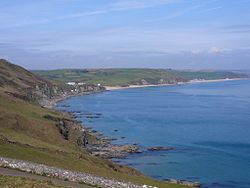
To the north it includes part of Dartmoor National Park, to the east borders Torbay, and to the west Plymouth. It contains some of the most unspoilt coastline on the south coast, including the promontories of Start Point, and Bolt Head. The entire coastline, along with the lower Avon and Dart valleys, form most of the South Devon Area of Outstanding Natural Beauty. The South Hams, along with nearby Broadsands in Paignton, is the last British refuge of the cirl bunting.
Torcross beach slapton sands south hams devon england uk
History
The South Hams were originally part of the Brythonic (Celtic) Kingdom of Dumnonia later reduced to the modern boundary at the River Tamar as Cornwall presumably during the tenth-century reign of Æthelstan. Post-Roman settlement on coastal promontory hillforts, such as Burgh Island, follows the established pattern of trading—of tin in particular—found across the western, so-called 'Celtic', Atlantic coastal regions. In the later Anglo-Saxon era, the South Hams was a feudal estate consisting of all of the land between the River Plym and River Dart and south of Dartmoor with the English Channel forming the southern boundary. There is some evidence that Cornish was spoken and understood in the area until the late Middle Ages.
In 1917, the village of Hallsands was abandoned after much of it was lost to the sea. This happened because the shingle bank protecting the shore was removed to help build Devonport dockyard.
In 1944 several villages were evacuated so that training for D-Day could be carried out in secret. The area was chosen because of the resemblance of its beaches to those of Normandy. Preparations were disrupted, and secrecy nearly compromised, by a devastating E-boat attack during Exercise Tiger. In 1967, the suburban towns of Plympton and Plymstock were amalgamated with the City of Plymouth.
The current district was formed on 1 April 1974, under the Local Government Act 1972, by the merger of:
Geography
Geography divides into three unequal, fuzzy bands, one with bays, headlands, the birdlife, fishing and small harbour towns' estuaries and rias; an unequal wide-ranging elevations middle band with the main, well-conserved towns and; a sparsely populated, upland National Park moorland in the north. For over a century its tourism was concentrated around the railway, with most stations built here from 1847-1872 so tourism to its beaches and fishing villages began in earnest much later than to the 'English Riviera' east of the area. South Hams' widespread tourism multiplied on the dualling of the A38 and time-cutting construction of the M5 and A303 across other parts of the rest of England.
In the north, there is...the "wildscape"—...[a new] bypass [to the A30, the A38]...cut[s] through some of the most beautiful country in Britain, that of the Dartmoor national park....while in the south-west there is extensive mining of china clay...[an abortive] tungsten mine in the Shaugh Prior — Sparkwell area will be [would have been] amongst the largest in the world and probably the largest in Europe. The wildscape band runs from Cadover Bridge and Shaugh Prior in the west right over to the other side of Dartmoor, to the Avon dam, Shipley Bridge and South Brent, touching the outskirts of Buckfastleigh.
The second band is the agricultural belt of lush, fertile farmland which produces some of the finest milk and Devon cream. Within that belt are the medieval towns of Modbury and Totnes and small hamlets and villages such as...Holbeton, Marldon and Berry Pomeroy, which would no doubt produce very fine wine if it were French. There are fruit farms and vineyards and the land flows with milk and honey.