
Prominence 554 m Easiest route Hiking | Elevation 3,493 m Mountain range Sierra Nevada Parent range Sierra Nevada | |
 | ||
Similar Leavitt Peak, White Mountain Peak, Freel Peak, Mount Lyell, Mount Morgan | ||
Sonora peak ca
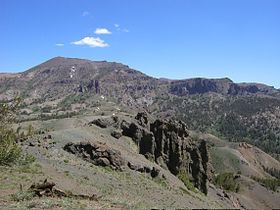
Sonora Peak is a mountain located in the Central Sierra Nevada mountains of California north of Sonora Pass. Located on the boundary between Alpine and Mono counties, it is the highest point in Alpine County. Due to the high elevation, most of the precipitation this mountain receives consists of snow.
Contents
- Sonora peak ca
- Map of Sonora Peak California USA
- Sonora pass camp hike june 2014 sonora peak
- References
Map of Sonora Peak, California, USA
One of the most direct routes of ascent starts at Sonora Pass, 2 miles (3.2 km) south as the crow flies. Starting at the trailhead of the PCT on Sonora Pass, it is about a 2.5-mile (4.0 km) hike with 1,000 feet (300 m) elevation gain to the top of a pass. From there, the easiest and most direct way is to turn Northwest and follow the ridge that will lead to the summit. About halfway from the pass to the peak a small trail appears that heads directly to the peak.