
Elevation 3,527 m Parent range Sierra Nevada | Prominence 625 m | |
 | ||
Easiest route off trail hike, class 1 Similar Sonora Peak, Mount Morgan, Mount Pinchot, Mount Kaweah, Mount Conness | ||
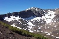
Leavitt peak ca 11 500el gone fishin caught views
Leavitt Peak is located in the Emigrant Wilderness near Sonora Pass in the eastern Sierra Nevada range of California. Leavitt Peak is located on the Tuolumne County - Mono County line. The Pacific Crest Trail runs close to the east of Leavitt Peak, at an elevation of about 10,800 feet (3,290 m) elevation. The peak offers views south to Yosemite National Park and north towards South Lake Tahoe.
Contents
- Leavitt peak ca 11 500el gone fishin caught views
- Map of Leavitt Peak California USA
- Sonora pass jun 13 leavitt peak panorama
- References
Map of Leavitt Peak, California, USA
Leavitt Peak is named for Hiram Leavitt, a native of New Hampshire, who built a hotel and home in 1863 at the foot of the east end of Sonora Pass to serve the growing number of travelers between Sonora and Aurora, primarily miners headed to the gold mines at nearby Bodie. Leavitt also erected a stagecoach station at what is called Leavitt Station. Leavitt was an early judge in Mono County. Leavitt Peak is a popular hiking destination. Leavitt Lake and Leavitt Meadow are nearby along the West Walker River and are also named for the early Leavitt family settlers. Leavitt's is recorded on Charles F. Hoffmann's map of 1873. and Levitt Peak appears on the Mining Bureau map of 1891.