
Founded May 14, 1688 Website www.co.somerset.nj.us Population 330,585 (2013) Unemployment rate 4.8% (Apr 2015) | Area 789.6 km² | |
 | ||
Colleges and Universities Destinations | ||
Somerset county new jersey at home swim lessons
Somerset County is a county located in the U.S. state of New Jersey. As of the 2010 United States Census, the county's population was 323,444, increasing by 25,954 (+8.7%) from the 297,490 counted in the 2000 Census, retaining its position as the state's 13th-most populous county. As of the 2016 Census estimate, the county's population was 333,751, making it the 13th-most populous of the state's 21 counties, representing a 3.2% increase from 2010. Somerset County is part of the New York Metropolitan Area. Its county seat is Somerville. The most populous place was Franklin Township, with 62,300 residents at the time of the 2010 Census, while Hillsborough Township, covered 55.00 square miles (142.4 km2), the largest total area of any municipality.
Contents
- Somerset county new jersey at home swim lessons
- Map of Somerset County NJ USA
- History
- Geography
- Adjacent counties
- Climate and weather
- Census 2010
- Census 2000
- Parks and recreation
- Government
- Politics
- Legal
- Taxation
- Education
- Municipalities
- Roads and highways
- Public transportation
- References
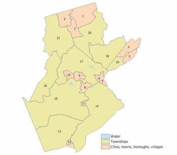
Map of Somerset County, NJ, USA
Somerset County, as of the 2000 Census, was the seventh-wealthiest county in the United States by median household income at $76,933 (third in New Jersey behind Hunterdon County at $79,888 and Morris County at $77,340), fourth in median family income at $90,655 (second in New Jersey behind Hunterdon County at $91,050) and ranked seventh by per capita income at $37,970 (highest in New Jersey). The Bureau of Economic Analysis ranked the county as having the 11th-highest per capita income of all 3,113 counties in the United States (and the highest in New Jersey) as of 2009. In 2012, 49.8 percent of Somerset County residents were college graduates, the highest percentage in the state.
Somerset County was created on May 14, 1688, from portions of Middlesex County.
History
Somerset County is one of America's oldest counties, and is named after the English county of Somerset. The area was first settled in 1681, in the vicinity of Bound Brook, and the county was established by charter on May 22, 1688. Most of the early residents were Dutch. General George Washington and his troops marched through the county on several occasions and slept in many of the homes located throughout the area. Somerset County also played an important part during both World War I and World War II with weapons depots and the manufacturing of the army's woolen blankets.
For much of its history, Somerset County was primarily an agricultural county. In the late 19th century, the Somerset Hills area of Somerset County became a popular country home for wealthy industrialists. The area is still the home of wealthy pharmaceutical industrialists.
In 1917, Somerset County, in cooperation with Rutgers University, hired its first agricultural agent to connect local farmers with expert advice. The Rutgers Cooperative Extension of Somerset County, located in Bridgewater, serves residents in the areas of agriculture and natural resources, 4-H youth development and family and community health sciences.
In the 1960s, townships that were once exclusively agricultural were quickly transformed into suburban communities. Examples include Bridgewater Township and the Watchung Hills communities of Watchung, Green Brook and Warren Township. This growth was aided by the development of the county's very strong pharmaceutical and technology presence. Warren Township used to be considered "the greenest place in New Jersey." More recently, there has been an influx of New York City commuters who use New Jersey Transit's Raritan Valley Line and Gladstone Branch or use Interstate 78.
Geography
According to the 2010 Census, the county had a total area of 304.86 square miles (789.6 km2), including 301.81 square miles (781.7 km2) of land (99.0%) and 3.04 square miles (7.9 km2) of water (1.0%).
The high point is on Mine Mountain in Bernardsville, at approximately 860 feet (260 m) above sea level. The lowest point is just above sea level on the Raritan River at the Middlesex County line.
Adjacent counties
Somerset County borders the following counties:
Climate and weather
In recent years, average temperatures in the county seat of Somerville have ranged from a low of 18 °F (−8 °C) in January to a high of 85 °F (29 °C) in July, although a record low of −16 °F (−27 °C) was recorded in January 1984 and a record high of 105 °F (41 °C) was recorded in August 1955. Average monthly precipitation ranged from 2.84 inches (72 mm) in February to 4.83 inches (123 mm) in July.
Census 2010
The 2010 United States Census counted 323,444 people, 117,759 households, and 84,669 families residing in the county. The population density was 1,071.7 per square mile (413.8/km2). The county contained 123,127 housing units at an average density of 408 per square mile (158/km2). The racial makeup of the county was 70.06% (226,608) White, 8.95% (28,943) Black or African American, 0.17% (556) Native American, 14.11% (45,650) Asian, 0.03% (94) Pacific Islander, 4.13% (13,360) from other races, and 2.55% (8,233) from two or more races. Hispanics or Latinos of any race were 13.01% (42,091) of the population.
Out of a total of 117,759 households, 35.9% had children under the age of 18 living with them, 58.8% were married couples living together, 9.5% had a female householder with no husband present, and 28.1% were non-families. 23.3% of all households were made up of individuals, and 8.5% had someone living alone who was 65 years of age or older. The average household size was 2.71 and the average family size was 3.22.
In the county, 25% of the population were under the age of 18, 6.5% from 18 to 24, 26.4% from 25 to 44, 29.8% from 45 to 64, and 12.4% who were 65 years of age or older. The median age was 40.2 years. For every 100 females the census counted 95.1 males, but for 100 females at least 18 years old, it was 91.8 males.
Census 2000
At the 2000 United States Census there were 297,490 people, 108,984 households and 78,359 families residing in the county. The population density was 976 per square mile (377/km²). There were 112,023 housing units at an average density of 368 per square mile (142/km²). The racial makeup of the county was 79.34% White, 7.53% Black or African American, 0.13% Native American, 8.38% Asian, 0.04% Pacific Islander, 2.74% from other races, and 1.83% from two or more races. 8.68% of the population were Hispanic or Latino of any race. Among those residents listing their ancestry, 18.7% were of Italian, 15.6% Irish, 14.5% German, 9.6% Polish and 7.1% English ancestry according to Census 2000.
There were 108,984 households of which 36.20% had children under the age of 18 living with them, 60.60% were married couples living together, 8.20% had a female householder with no husband present, and 28.10% were non-families. 22.80% of all households were made up of individuals and 7.00% had someone living alone who was 65 years of age or older. The average household size was 2.69 and the average family size was 3.19.
Age distribution was 25.50% under the age of 18, 5.90% from 18 to 24, 33.80% from 25 to 44, 23.50% from 45 to 64, and 11.20% who were 65 years of age or older. The median age was 37 years. For every 100 females there were 95.40 males. For every 100 females age 18 and over, there were 92.10 males.
The median household income was $76,933 and the median family income was $90,605. Males had a median income of $60,602 versus $41,824 for females. The per capita income for the county was $37,970. About 2.3% of families and 8.8% of the population were below the poverty line, including 3.7% of those under age 18 and 4.9% of those age 65 or over.
Parks and recreation
Somerset County parks include Lord Stirling Park (part of the Great Swamp National Wildlife Refuge), Colonial Park (with a lovely rose garden), Washington Valley Park (with biking and hiking trails), the Sourland Mountain Preserve (hiking and mountain biking trails), and the newest park in development called Raritan River Greenway (which is being developed along the Raritan River in Bridgewater Township).
The southeastern portion of Somerset County in Franklin Township also includes the Delaware and Raritan Canal State Park, which provides hiking, biking and boating.
Trump National Golf Club in Bedminster is an exclusive golf club owned by Donald Trump.
The Somerset Patriots are a professional baseball team who plays at TD Bank Ballpark, located on the border of Bridgewater and Bound Brook, New Jersey. They play in the independent Atlantic League of Professional Baseball.
Government
Somerset County is governed by a five-member Board of Chosen Freeholders, whose members are elected at-large to three-year terms of office on a staggered basis, with one or two seats coming up for election each year. At an annual reorganization meeting held on the first Friday of January, the board selects a Director and Deputy Director from among its members. As of January 2015, Somerset County's Freeholders are:
Constitutional officers elected on a countywide basis are County Clerk Brett A. Radi (R, Somerville, 2017), Sheriff Frank J. Provenzano (R, Raritan, 2016) and Surrogate Frank Bruno (R, Branchburg, 2015).
Somerset County is a part of Vicinage 13 of the New Jersey Superior Court (along with Hunterdon County and Warren County), which is seated at the Somerset County Courthouse in Somerville; the Assignment Judge for Vicinage 15 is the Honorable Yolanda Ciccone.
The Freeholders employ a full-time County Administrator who manages the day-to-day operations of County government. The current County Administrator is Michael J. Amorosa. The Clerk of the Board of Freeholders oversees the work of their offices. Department heads are appointed in accordance with statute and by resolution of the board. Somerset County currently has approximately 1,100 full-time and 130 part-time employees in 52 divisions (including the Library System).
The 7th and 12th Congressional Districts cover the county. New Jersey's Seventh Congressional District is represented by Leonard Lance (R, Clinton Township). New Jersey's Twelfth Congressional District is represented by Bonnie Watson Coleman (D, Ewing Township).
The county is part of the 16th, 17th, 21st, 22nd, 23rd and 25th Districts in the New Jersey Legislature. For the 2016–2017 session (Senate, General Assembly), the 16th Legislative District of the New Jersey Legislature is represented in the State Senate by Christopher Bateman (R, Branchburg) and in the General Assembly by Jack Ciattarelli (R, Hillsborough Township) and Andrew Zwicker (D, South Brunswick). For the 2016–2017 session (Senate, General Assembly), the 17th Legislative District of the New Jersey Legislature is represented in the State Senate by Bob Smith (D, Piscataway) and in the General Assembly by Joseph Danielsen (D, Franklin Township) and Joseph V. Egan (D, New Brunswick) For the 2016–2017 session (Senate, General Assembly), the 21st Legislative District of the New Jersey Legislature is represented in the State Senate by Thomas Kean Jr. (R, Westfield) and in the General Assembly by Jon Bramnick (R, Westfield) and Nancy Munoz (R, Summit). For the 2016–2017 session (Senate, General Assembly), the 22nd Legislative District of the New Jersey Legislature is represented in the State Senate by Nicholas Scutari (D, Linden) and in the General Assembly by Jerry Green (D, Plainfield) and James J. Kennedy (D, Rahway). For the 2016–2017 session (Senate, General Assembly), the 23rd Legislative District of the New Jersey Legislature is represented in the State Senate by Michael J. Doherty (R, Washington Township, Warren County) and in the General Assembly by John DiMaio (R, Hackettstown) and Erik Peterson (R, Franklin Township, Hunterdon County). For the 2016–2017 session (Senate, General Assembly), the 25th Legislative District of the New Jersey Legislature is represented in the State Senate by Anthony Bucco (R, Boonton Town) and in the General Assembly by Tony Bucco (R, Boonton Township) and Michael Patrick Carroll (R, Morris Township).
Politics
Somerset County has been known as one of New Jersey's more conservative counties.
As of October 31, 2014, there were a total of 216,901 registered voters in Somerset County, of whom 55,782 (25.7%) were registered as Democrats, 53,345 (24.6%) were registered as Republicans and 107,546 (49.6%) were registered as Unaffiliated. There were 228 voters registered to other parties. Among the county's 2010 Census population, 67.1% were registered to vote, including 75.% of those ages 18 and over.
In the 2004 presidential election, George W. Bush carried Somerset County by a 4.3% margin over John Kerry, with Kerry carrying the state by 6.7% over Bush. However, in 2008, Barack Obama became the first Democratic Presidential nominee to carry the county since Lyndon Johnson in 1964. Obama won Somerset by a 6.1% margin over John McCain, with Obama carrying the state by 15.5% over McCain.
In the 2009 Gubernatorial Election, Republican Chris Christie received 56% of the vote, defeating Democrat Jon Corzine, who received around 34%. In the 2012 presidential election, the county was carried by Barack Obama, winning 52.8% of the vote to Mitt Romney's 47.2%, a 5.6% gap that represented a 0.5% drop off for Obama from his 2008 margin of victory in the county.
Legal
In 1996, Nicholas L. Bissell Jr., then county prosecutor, was charged with embezzlement, tax fraud and abuse of power. He fled to Laughlin, Nevada, near Las Vegas and took his own life when the federal authorities attempted to arrest him.
Taxation
Based on IRS data for the 2004 tax year, Somerset County taxpayers had the ninth-highest average federal income tax liability per return in the country. Average tax liability was $16,502, representing 16.8% of Adjusted Gross Income.
Education
Somerset County is home to two colleges:
Alma White College, (1921 to 1978) was a private college located in Zarephath. Beginning in 1931 the college operated WAWZ 1380 on the AM radio dial. The station continued to 1984 after the school closed. The building is now occupied by Somerset Christian College.
Somerset Hills Learning Institute is a state-of-the-art program dedicated to educating children on the autism spectrum by utilizing the principles of ABA.
Municipalities
Municipalities in Somerset County (with 2010 Census data for population, housing units and area) are listed below. Other, unincorporated communities in the county are listed alongside their parent municipality (or municipalities, as the case may be). These areas include census-designated places (CDPs), which have been created by the United States Census Bureau for enumeration purposes within a Township. Other communities, historical areas, unincorporated areas, and enclaves that exist within a municipality are also listed.
Roads and highways
Somerset County is served by a number of different routes. As of May 2010, the county had a total of 1,714.99 miles (2,760.01 km) of roadways, of which 1,370.80 miles (2,206.09 km) were maintained by the local municipality, 234.23 miles (376.96 km) by Somerset County and 109.96 miles (176.96 km) by the New Jersey Department of Transportation.
Major county roads that pass through include County Route 512, County Route 514, County Route 518, County Route 523, County Route 525, County Route 527, County Route 529, County Route 531 and County Route 533.
The only two state routes that traverse through are Route 27 (only in Franklin) and Route 28.
U.S. Routes include U.S. Route 22, U.S. Route 202 and U.S. Route 206.
The two interstates that pass through are Interstate 78 and Interstate 287.
Interstate 95 was planned to run along the Somerset Freeway from its proposed southern end in Hopewell Township, Mercer County to Franklin Township at I-287 in the 1960s. However, this plan was cancelled in 1983.
Route 18 runs at the New Brunswick border of Somerset.
Public transportation
New Jersey Transit provides train service on the Gladstone Branch and the Raritan Valley Line. Public bus transportation is provided by several transit agencies.
NJ Transit provides bus service to the Port Authority Bus Terminal in Midtown Manhattan, as well as service to major cities in New Jersey and within Somerset County. Ridewise provides three SCOOT shuttles as well as DASH buses and CAT buses.