
Population 2,920 (1992) Area 2,611 km² | Established 1862 Founded 1862 Region Wimmera | |
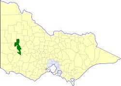 | ||
The Shire of Wimmera was a local government area in the Wimmera region of western Victoria, Australia. The shire covered an area of 2,611 square kilometres (1,008.1 sq mi), and existed from 1862 until 1995. Although its shire offices were located in Horsham, Horsham was governed by a separate city council.
Contents
History
Wimmera was incorporated as a road district on 3 March 1862, and became a shire on 4 March 1864. It was originally a very large district, including a significant portion of Walpeup, plus Arapiles, Dimboola, Dunmunkle, Kaniva, Kowree, Lowan, centred on the town of Horsham. By 1900, all of these areas had severed and separately incorporated, and Wimmera's boundaries remained largely unchanged for over 90 years.
On 20 January 1995, the Shire was abolished, and merged with City of Horsham, most of the Shire of Arapiles and part of Kowree into the Rural City of Horsham. The section within Grampians National Park became part of the Shire of Northern Grampians, whilst the Kewell West and Wallup districts joined the Shire of Yarriambiack.
Wards
Wimmera was divided into four ridings, each of which elected three councillors:
Towns and localities
Population
* Estimates in 1958, 1983 and 1988 Victorian Year Books.