
Population 3,310 (1992) Shire of Walpeup Swan HillWycheproof Founded 1911 | Established 1911 Area 10,964 km² Council seat Ouyen | |
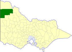 | ||
The Shire of Walpeup was a local government area in northwestern Victoria, Australia, along the South Australian border. The shire covered an area of 10,964 square kilometres (4,233.2 sq mi), and existed from 1911 until 1995.
Contents
History
Walpeup was incorporated as a shire on 1 November 1911, created out of parts of the Shires of Mildura, Swan Hill, Lawloit, Lowan, Dimboola and Karkarooc.
On 20 January 1995, the Shire was abolished, and merged with the City and Shire of Mildura into the Rural City of Mildura.
Wards
Walpeup was divided into four ridings in 1986, each of which elected three councillors:
Towns and localities
Population
* Estimate in the 1958 Victorian Year Book.
References
Shire of Walpeup Wikipedia(Text) CC BY-SA