
Population 2,620 (1992) Area 2,606 km² | Established 1861 Founded 1861 | |
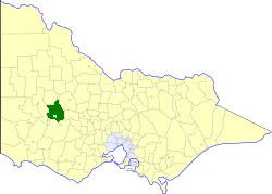 | ||
The Shire of Stawell was a local government area about 230 kilometres (143 mi) west-northwest of Melbourne, the state capital of Victoria, Australia. The shire covered an area of 2,606 square kilometres (1,006.2 sq mi), and existed from 1861 until 1994.
Contents
History
Stawell was first incorporated as a road district on 29 January 1861, and became a shire on 30 December 1864. On 26 October 1926, it annexed part of the North Riding of the Shire of Ararat.
On 20 January 1995, the Shire was abolished, and merged with Town of St Arnaud, City of Stawell, most of the Shire of Kara Kara, the Grampians National Park within the Shire of Wimmera and parts of the Shires of Ararat, Avoca, Donald and Dunmunkle into the Shire of Northern Grampians. The Armstrong district passed into the Rural City of Ararat.
Wards
Stawell was divided into four ridings, each of which elected three councillors:
Towns and localities
Population
* Estimate in the 1958 Victorian Year Book.
# 1981 census says 2,306 for 1976.