
Population 3,960 (1992) Area 1,907 km² | Established 1919 Shire of Otway Bass Strait Founded 1919 | |
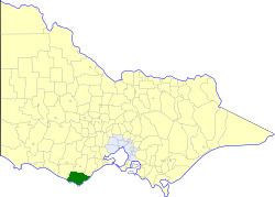 | ||
The Shire of Otway was a local government area about 190 kilometres (118 mi) southwest of Melbourne, the state capital of Victoria, Australia. The shire covered an area of 1,906.94 square kilometres (736.3 sq mi), and existed from 1919 until 1994.
Contents
History
Otway was incorporated as a shire on 6 May 1919, carved out of parts of the Shires of Colac, Heytesbury and Winchelsea. In 1964, it annexed further parts of Heytesbury (in Coradjil Parish) and Winchelsea (in Kanglang Parish). In 1969, it lost the town of Simpson to Heytesbury.
On 23 September 1994, the Shire was abolished, and merged with City and most of the Shire of Colac and parts of the Shires of Heytesbury and Winchelsea into the Shire of Colac Otway. The town of Princetown merged west into the Shire of Corangamite.
Wards
Otway was divided into four ridings in 1987, each of which elected three councillors:
Towns and localities
Population
* Estimate in the 1958 Victorian Year Book.