
Population 7,230 (1992) Founded 1859 | Established 1859 Area 1,458 km² | |
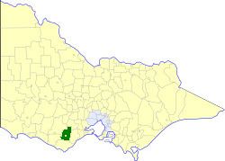 | ||
The Shire of Colac was a local government area about 150 kilometres (93 mi) west-southwest of Melbourne, the state capital of Victoria, Australia. The shire covered an area of 1,458.2 square kilometres (563.0 sq mi), and existed from 1859 until 1994.
Contents
History
Colac was first incorporated as a road district on 11 May 1859, and became a shire on 10 May 1864. On 31 May 1901, it was divided into four ridings, although these were later abolished. A significant portion of the shire, along with the Shires of Heytesbury and Winchelsea, seceded on 6 May 1919, to form the Shire of Otway. On 19 January 1938, the town of Colac itself split away, to form the Borough of Colac, later proclaimed as the City of Colac, on 26 January 1960.
On 23 September 1994, the Shire of Colac was abolished, and, along with the City of Colac, the Shire of Otway, and parts of the Shires of Heytesbury and Winchelsea, was merged into the newly created Colac-Otway Shire.
Population
* Estimate in the 1958 Victorian Year Book.