
Population 1,680 (1992) Founded 1872 | Established 1872 Area 5,641 km² Council seat Omeo | |
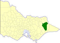 | ||
The Shire of Omeo was a local government area about 390 kilometres (242 mi) east-north-east of Melbourne, the state capital of Victoria, Australia. The shire covered an area of 5,641 square kilometres (2,178.0 sq mi), and existed from 1872 until 1994.
Contents
History
Omeo was incorporated as a shire on 25 October 1872.
On 2 December 1994, the Shire was abolished, and merged with City and Shire of Bairnsdale, Shire of Tambo and the Boole Boole Peninsula from Shire of Rosedale into the Shire of East Gippsland. The Dinner Plain district merged into the Alpine Shire which had been created two weeks earlier.
Wards
Omeo was divided into four ridings on 15 January 1957, each of which elected three councillors:
Towns and localities
Population
* Estimate in the 1958 Victorian Year Book.
References
Shire of Omeo Wikipedia(Text) CC BY-SA