Girish Mahajan (Editor)

County of Benambra

Updated on
Edit
Like
Comment
Share on FacebookTweet on TwitterShare on LinkedInShare on Reddit
Established
  
24 February 1871

Area
  
7,120 kmĀ²

Benambra
  
Selwyn (NSW)

Founded
  
24 February 1871

County of Benambra

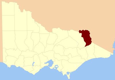
The County of Benambra is one of the 37 counties of Victoria which are part of the cadastral divisions of Australia, used for land titles. It is located between the Mitta Mitta River in the west, and the Murray River to the north and east. The town of Benambra is located near the southern edge. The area of the county roughly corresponds with the Electoral district of Benambra. Corryong is the largest town in the region.

Parishes

Parishes include:

  • Adjie, Victoria
  • Beloka, Victoria
  • Benambra, Victoria
  • Berringa, Victoria
  • Berringama, Victoria
  • Bullioh, Victoria
  • Bungil East, Victoria
  • Bungil, Victoria
  • Burrowye, Victoria
  • Burrungabugge, Victoria
  • Canabore, Victoria
  • Cobungra, Victoria
  • Colac Colac, Victoria
  • Corryong, Victoria
  • Cudgewa, Victoria
  • Dartella, Victoria
  • Enano, Victoria
  • Gibbo, Victoria
  • Granya, Victoria
  • Gungarlan, Victoria
  • Hinno-Munjie, Victoria
  • Indi, Victoria
  • Jemba, Victoria
  • Jinderboine, Victoria
  • Jinjellic, Victoria
  • Kancobin, Victoria
  • Keelangie, Victoria
  • Koetong, Victoria
  • Kosciusko, Victoria
  • Malkara, Victoria
  • Mitta Mitta, Victoria
  • Mowamba, Victoria
  • Moyangul, Victoria
  • Nariel, Victoria
  • Pinnibar, Victoria
  • Talgarno, Victoria
  • Tatonga, Victoria
  • Thologolong, Victoria
  • Thorkidaan, Victoria
  • Thowgla, Victoria
  • Tintaldra, Victoria
  • Towong, Victoria
  • Wabba, Victoria
  • Wagra, Victoria
  • Walwa, Victoria
  • Welumla, Victoria
  • Wyeeboo, Victoria
  • Yabba, Victoria
  • References

    County of Benambra Wikipedia