Girish Mahajan (Editor)

County of Dargo

Updated on
Edit
Like
Comment
Share on FacebookTweet on TwitterShare on LinkedInShare on Reddit
Established
  
24 February 1871

Area
  
5,272 kmĀ²

Dargo
  
Tambo

Founded
  
24 February 1871

County of Dargo

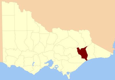
The County of Dargo is one of the 37 counties of Victoria which are part of the cadastral divisions of Australia, used for land titles. It is located in Gippsland, between the Mitchell River in the west and the Tambo River in the east. Lake King is on the southern edge. It was gazetted in 1871. Earlier maps show the area as being part of a proposed County of Abinger.

Parishes

Parishes include:

  • Angora, Victoria
  • Barroworn, Victoria
  • Bemboka, Victoria
  • Binnican, Victoria
  • Birregun, Victoria
  • Boonderoot, Victoria
  • Broadlands, Victoria
  • Bulgaback, Victoria
  • Bullumwaal, Victoria
  • Bumberrah, Victoria
  • Caarneek, Victoria
  • Carneek, Victoria
  • Cooma, Victoria
  • Cowa, Victoria
  • Dargo, Victoria
  • Doodwuk, Victoria
  • Graham, Victoria
  • Guttamurra, Victoria
  • Jirnkee, Victoria
  • Kalk Kalk, Victoria
  • Kianeek, Victoria
  • Koomberar, Victoria
  • Kooroon, Victoria
  • Moonip, Victoria
  • Morekana, Victoria
  • Mullawye, Victoria
  • Nungatta, Victoria
  • Nurong, Victoria
  • Onyim, Victoria
  • Quag-Munjie, Victoria
  • Sarsfield, Victoria
  • Tabberabbera, Victoria
  • Tambo, Victoria
  • Tarkeeth, Victoria
  • Terlite-Munjie, Victoria
  • Thornley, Victoria
  • Tongio-Munjie West, Victoria
  • Tyirra, Victoria
  • Wamba, Victoria
  • Wentworth, Victoria
  • Wongungarra, Victoria
  • Wuk Wuk, Victoria
  • Wy-Yung, Victoria
  • Yambulla, Victoria
  • Yertoo, Victoria
  • Yonduk, Victoria
  • References

    County of Dargo Wikipedia