Neha Patil (Editor)

County of Tambo, Victoria

Updated on
Edit
Like
Comment
Share on FacebookTweet on TwitterShare on LinkedInShare on Reddit
Established
  
24 February 1871

Area
  
5,091 kmĀ²

Tambo
  
Croajingolong

Founded
  
24 February 1871

County of Tambo, Victoria

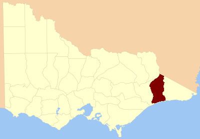
The County of Tambo is one of the 37 counties of Victoria which are part of the cadastral divisions of Australia, used for land titles. It is located in eastern Gippsland, between the Tambo River in the west, and the Snowy River in the east. It includes Lakes Entrance. Some time earlier maps showed proposed counties of Abinger and Combermere occupying the area.

Parishes

Parishes include:

  • Berrmarr, Victoria
  • Bete Bolong North, Victoria
  • Bete Bolong South, Victoria
  • Bindi, Victoria
  • Buchan, Victoria
  • Chilpin, Victoria
  • Colquhoun, Victoria
  • Colquhoun East, Victoria
  • Colquhoun North, Victoria
  • Detarka, Victoria
  • Ensay, Victoria
  • Eucambene, Victoria
  • Eumana, Victoria
  • Forest Hill, Victoria
  • Gelantipy East, Victoria
  • Gelantipy West, Victoria
  • Gillingal, Victoria
  • Glenmore, Victoria
  • Ingeegoobee, Victoria
  • Kaerwut, Victoria
  • Karawah, Victoria
  • Maneroo, Victoria
  • Marroo, Victoria
  • Mellick-Munjie, Victoria
  • Menaak, Victoria
  • Murrindal East, Victoria
  • Murrindal West, Victoria
  • Nappa, Victoria
  • Newmerella, Victoria
  • Ninnie, Victoria
  • Nowa Nowa, Victoria
  • Nowa Nowa South, Victoria
  • Noyong, Victoria
  • Numbie-Munjie, Victoria
  • Tildesley East, Victoria
  • Tildesley West, Victoria
  • Timbarra, Victoria
  • Tongio-Munjie East, Victoria
  • Toonginbooka, Victoria
  • Waygara, Victoria
  • Windarra, Victoria
  • Woongulmerang East, Victoria
  • Woongulmerang West, Victoria
  • References

    County of Tambo, Victoria Wikipedia