
Population 6,960 (1992) Area 2,621 km² | Established 1857 Founded 1857 | |
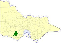 | ||
The Shire of Hampden was a local government area about 200 kilometres (124 mi) west-southwest of Melbourne, the state capital of Victoria, Australia. The shire covered an area of 2,620.91 square kilometres (1,011.9 sq mi), and existed from 1857 until 1994.
Contents
History
Hampden was first incorporated as the Hampden and Heytesbury Road District on 28 April 1857, and became a shire on 31 December 1863. On 31 May 1895, it lost parts of its East and West Wards, to create the Shire of Heytesbury. On 9 September 1952, the Borough of Camperdown severed from its East Riding. Its boundary was adjusted on 31 May 1977, to include all of Skipton.
On 23 September 1994, the Shire of Hampden was abolished, and, along with the Town of Camperdown and parts of the Shires of Colac, Heytesbury and Mortlake, and the area around Princetown, on the Great Ocean Road, was amalgamated into the newly created Shire of Corangamite.
Wards
The Shire of Hampden was divided into three ridings, each of which elected three councillors:
Towns and localities
Population
* Estimate in the 1958 Victorian Year Book.