
Population 3,070 (1992) Area 2,137 km² | Established 1860 Founded 1860 | |
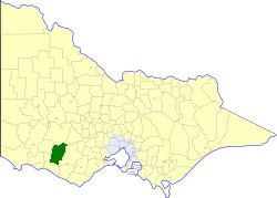 | ||
The Shire of Mortlake was a local government area about 220 kilometres (137 mi) west of Melbourne, the state capital of Victoria, Australia. The shire covered an area of 2,137 square kilometres (825.1 sq mi), and existed from 1860 until 1994.
Contents
History
Mortlake was incorporated as a road district on 20 July 1860, and became a shire on 26 January 1864.
On 23 September 1994, the Shire of Mortlake was abolished, and, along with the Borough of Port Fairy, the Tower Hill Reserve, the Shires of Belfast and Minhamite, and parts of the Shires of Dundas, Mount Rouse and Warrnambool, was merged into the newly created Shire of Moyne.
Wards
The Shire of Mortlake was divided into four ridings on 7 June 1978, each of which elected three councillors:
Towns and localities
Population
* Estimate in the 1958 Victorian Year Book.