
- elevation 4,553 ft (1,388 m) - elevation 1,621 ft (494 m) Length 143 km Basin area 554.3 km² | - average 445 cu ft/s (13 m/s) Basin area 554.3 km² | |
 | ||
- max 27,600 cu ft/s (782 m/s) (2010) Source Pocahontas County, West Virginia | ||
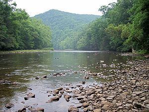
2013 07 17 shavers fork of the cheat river near bemis wv
Shavers Fork of the Cheat River is situated in the Allegheny Mountains of eastern West Virginia, USA. It is 88.5 mi (142.5 km) long and forms the Cheat at its confluence with Black Fork at Parsons. It was traditionally considered one of the five Forks of Cheat and its upper reaches constitute the highest river in the eastern United States.
Contents
- 2013 07 17 shavers fork of the cheat river near bemis wv
- Map of Shavers Fork West Virginia USA
- Shavers fork at bemis
- GeographyEdit
- NamesEdit
- References
Map of Shavers Fork, West Virginia, USA
Shavers fork at bemis
GeographyEdit
Shavers Fork, via the Cheat, Monongahela and Ohio Rivers, is part of the watershed of the Mississippi River, draining an area of 214 mi² (554 km²). It flows for much of its length through the Monongahela National Forest, and drains mostly rural and forested areas. 97% of the river's basin is forested, and two-thirds of it is public land.
Shavers Fork rises in north-central Pocahontas County at Thorny Flat, highest peak of Cheat Mountain (4,848 ft/1,478 m) and the site of Snowshoe Mountain ski resort. Its headwaters flow through the ghost town of Spruce. The river then flows generally north-northeastwardly through Randolph and Tucker Counties, where its valley is the trough between Cheat Mountain (to the west) and Shavers Mountain (to the east). Settlements along its course include Cheat Bridge, Bemis, Bowden, and Porterwood. The "High Falls of Cheat" (15 feet [4.6 m] high) is a few miles upstream of Bemis. Shavers Fork ultimately joins the Black Fork at Parsons to form the Cheat at an elevation of 1621 ft (494 m).
NamesEdit
The creek was named after the local Shaver family. According to the Geographic Names Information System, Shavers Fork has also been known historically as: