
Elevation 900 m (3,000 ft) | Local time Wednesday 9:53 PM | |
 | ||
Region Trentino-Alto Adige/Südtirol Frazioni Sarnthein (Sarentino), Aberstückl (Sonvigo), Agratsberg (Acereto), Astfeld (Campolasta), Auen (Prati), Außerpens (Pennes di Fuori), Dick (Spessa ), Durnholz (Valdurna), Essenberg (Montessa), Gebracksberg (Campo di Ronco), Gentersberg, Glern (Collerno), Innerpens (Pennes di Dentro), Kandelsberg, Muls (Mules), Niederwangen (Vangabassa), Nordheim (Villa), Öttenbach (Riodeserto), Putzen (Pozza), Reinswald (S.Martino), Riedelsberg (Montenovale), Rungg, Steet (Stetto), Trienbach (Trina), Unterreinswald (Boscoriva), Vormeswald (Selva di Vormes), Weissenbach (Riobianco), Windlahn (Lana al Vento) Demonym(s) German: Sarntaler or SarnerItalian: Sarentini Weather 7°C, Wind S at 11 km/h, 78% Humidity Points of interest Penser Joch, Hirzer, Castel Regino, Penser Weißhorn, Rohrer haus | ||
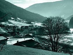
Sarntal ( [ˈsarntaˑl]; Italian: Sarentino [sarenˈtiːno]) is a valley and a comune (municipality) in South Tyrol in northern Italy, located about 15 kilometres (9 mi) north of the city of Bolzano. The municipality comprises several towns and villages. The largest one, seat of the mayor and council, is Sarnthein.
Contents
- Map of Sarntal Province of Bolzano South Tyrol Italy
- Geography
- History
- Coat of arms
- Linguistic distribution
- References
Map of Sarntal, Province of Bolzano - South Tyrol, Italy
Geography
Sarntal borders the following municipalities: Hafling, Freienfeld, Klausen, Franzensfeste, Mölten, Ratschings, Ritten, Jenesien, St. Leonhard in Passeier, Schenna, Vahrn, Vöran and Villanders. The Durnholzer See is located in the municipal territory. The valley contains some beautiful landscapes with mountains and flat space as well. The main river is the "Talfer", which has its source at the "Weisshorn" in the "Pensertal".
History
The village of Sarnthein was first mentioned in 1211.
Coat-of-arms
The emblem represents an or deer’s head on azure. The insignia looks like that of the various Lords who administered the territory since 1315, but since 1681 they were named Counts of Sarnthein (Grafen von Sarnthein) living in the Kellerburg Castle. The emblem was adopted in 1967.
Linguistic distribution
According to the 2011 census, 98.07% of the population speak German, 1.82% Italian and 0.10% Ladin as first language.