
Topo map 1414 IV Haukelisæter Prominence 543 m | Elevation 1,721 m | |
 | ||
Isolation 65.8 kilometres (40.9 mi) Similar Hårteigen, Folarskardnuten, Stornubben, Visbretinden, Nautgardstind | ||
Sandfloegga 1721 m o h 18 04 09
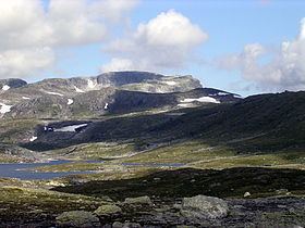
Sandfloegga or Sandfloeggi is a mountain in Odda municipality in southeastern Hordaland county, Norway. It lies on the southern part of the vast Hardangervidda mountain plateau, and is the highest mountain on Hardangervidda when the bordering summits of Hardangerjøkulen and Folarskardnuten are omitted. The 1,721-metre (5,646 ft) tall mountain lies inside Hardangervidda National Park, about 10 kilometres (6.2 mi) north of the European route E134 highway.
Contents
Map of Sandfloegga, 5760 R%C3%B8ldal, Norway
From the summit, the Folgefonna glacier is seen in the northwest, the mountain Hårteigen in the north, the Hallingskarvet mountain ridge in the northeast, and the mountain Gaustatoppen in the east.
References
Sandfloegga Wikipedia(Text) CC BY-SA