
Barangays Area 29.85 km² Area code 55 Dialling code 55 | Established July 25, 1949 Time zone PST (UTC+8) Population 17,561 (2015) | |
 | ||
District District of Northern Samar | ||
San Jose is a fifth class municipality in the Province of Northern Samar, Philippines. It is located at the north central part of the province, about 19 kilometres (12 mi) west of Catarman, the provincial capital, and about 30 kilometres (19 mi) east of Allen, where the ferry terminal is which connects the islands of Luzon, Samar, Leyte, and Mindanao via the Pan-Philippine Highway (formerly the Maharlika Highway). It is approximately 150 kilometres (93 mi) north-north-east of Tacloban City, the Regional Center of the Eastern Visayas. According to the 2015 census, it has a population of 17,561 people.
Contents
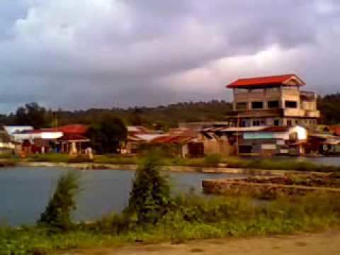
- Map of San Jose Northern Samar Philippines
- Geography
- Bodies of water
- Barangays
- History
- Local government
- Facilities
- Notable Carangianons in politics
- References
Map of San Jose, Northern Samar, Philippines
Politically, the municipality is bounded on the north by the Philippine Sea, on the east by the Municipality of Bobon, on the south by the Municipality of Victoria and on the west by the Municipality of Rosario.
Geography
San Jose's total land area of 2,985 hectares (7,380 acres) is generally underlain by well-bedded and moderately undulating terrain. The rock unit is probably part of the Mawo Volcanics, which is widespread in Northern Samar. The terrain is diversely oriented with inclination angles ranging from 10 degrees to 14 degrees. In the surveyed area, mangrove swamps dominate the western part of the municipality which extends to its northern coastline. In fact, more than half of the land area in the town proper, which is located at the northern coastline of the municipality are reclaimed lands from these swamplands.
Being a coastal town, it has several islets within its municipal waters off its northern coast: Cabaungon (or Cabanongan) Grande, Cabaungon Pequiño, Tandang, Pangilala, Puropangdan, Matungko, and Maghungaw. They are plentiful in fishes, crustaceans, and other marine products. These islands along the coast of San Jose are protected as part of the Biri Larosa Protected Landscape and Seascape.
The municipality is in a valley bounded on the east by the Palusong Mountain Range moving south and on the west by the Hitaasan Mountain Range. The land is generally alluvial flat and swamplands which has an elevation of less than 10 meters above sea level, while going south, south easterly, the physiography abruptly rises to moderately rugged hills with a peak of 68 metres (223 ft). The drainage system in the area generally flows north-east towards Carangian Channel. Vegetation in this area generally consists of mangrove trees and shrubs, cogonal growth, and coconuts. The flat areas are planted with rice, corn and coconuts.
There are small flat and level areas along Barangay Dao and Barangay Geratag creeks. There are also wide coastal swamps. Most of the agricultural land areas are located along the valley between Palusong Mountain Range, near Barangay Aguadahan, and Barangay Geratag in the east, and Hitaasan Mountain Range near Barangay Bagong Sabang and Barangay Bonglas in the west.
Bodies of water
The Carangian Channel is a marine channel along its northern shore, separating Samar Island from Cabaungon Island.
There are four large natural streams flowing through or within the municipality of San Jose: Gengarog River, Sinamangan River, Bobon River, and Nahalugan River.
Off the National Highway about 10 minutes walk toward the hillside, there are the Honeybee Falls. The falls are on private property, but accessible with permission.
Barangays
San Jose is politically subdivided into 16 barangays.
History
The Municipality of San Jose grew from a place that was then covered with bushes, shrubs, zacates, and marshes, where wild chicken, locally known as ilajas, abounded. It was then called carangian, being the site where hunters assembled their trap, known as carang, to catch wild chickens. In time, the word carangan was corrupted and the place began to be known as Carangian. Due to favorable economic opportunities, people migrated to the place. As the population grew, it became a barrio within the administrative jurisdiction of the Municipality of Bobon known as Carangian.
With the construction of a deep-sea port, steamers and ships from Manila and other countries began to dock in Carangian, which due to its strategic location and the presence of the well-protected deep-sea port, quickly became the main port entry of Northern Samar. As its economy boomed, the barrio aspired to become an independent municipality as early as 1932. In that year, the Governor of Samar, Pedro Arteche, conducted a plebiscite for the conversion of Barrio Carangian into a municipality. Due to the overwhelming negative votes in the Poblacion of Bobon and some other barrios, that was not realized.
Before the elections of 1949, the leaders of Carangian took advantage of a rift between President Elpidio Quirino and José Dira Avelino, President of the Senate, to separate from Bobon. A delegation was formed under the leadership of Eladio T. Balite, Representative of the first district of Samar. The delegation was dispatched to Manila to lobby for the independence of Carangian. After more than a month of going from office to office in Manila, the delegation succeeded in having the Barrio of Carangian created into the Municipality of San Jose. Eugenio Perez, Speaker of the House, was also instrumental in the creation of the new municipality. Thus, on July 25, 1949, by virtue of Executive Order No. 248 of the then President Elpidio Quirino, Carangian together with eleven other barrios became the new municipality of San Jose, named in honor of the late Jose Tagros Balite Sr, then Mayor of Bobon.
Local government
The first person to have been elected to the post of mayor of the newly created Municipality of San Jose (which at that time included now independent Municipality of Biri and some parts adjoining to form the Municipality of Rosario) is Roque H. Dato (1949–51). He is the father of Bayani A. Dato who also assumed the post of mayor of San Jose from 1968 to 1986, and from 1988 to 1995.
Don Francisco S. Evaristo, former Mayor of Bobon, was the next mayor of San Jose from 1952 to 1955. Other persons to have been elected mayor are: Agustin Pondemira (1956–67); Felipe Ballesta (1986–88); and Lazaro A. Ballesta (2001–07).
The current Mayor of San Jose is Clarence E. Dato.
Facilities
The Port of San Jose is a reinforced concrete general purpose pier handling passengers and domestic cargoes, situated in Barangay North. The pier is 138 metres (453 ft) long and 12 feet (3.7 m) wide with a controlling depth of 25 feet (7.6 m) alongside, with 8 rubber fenders and 9 mooring bit. Its storage facilities include an open storage of 940 square metres (10,100 sq ft), 2 transit sheds with total area of 744 square metres (8,010 sq ft), and 3 private warehouse with a total area of 1,060 square metres (11,400 sq ft).
Notable Carangianons in politics
Carangian (San Jose) is home to local notable persons in politics the Carangianons are proud of, to wit: