
Elevation 485 m | ||
 | ||
Road Interstate 10 in California Similar San Gorgonio Mountain, San Jacinto Mountains, San Jacinto Peak, Coachella Valley, Santa Rosa Mountains | ||
San Gorgonio Pass, sometimes referred to as Banning Pass due to the location of Banning, California at the western end of the pass, el. 2,600 ft (790 m), is a gap on the rim of the Great Basin between the San Bernardino Mountains to the north and the San Jacinto Mountains to the south, carrying Interstate 10 and the Union Pacific Railroad between the Los Angeles basin and the Coachella Valley. Like Cajon Pass to the northwest, it was created by the San Andreas Fault, with the valleys leading up to the pass aligned with the fault. The pass is not as steep as Cajon or Tejon passes, but it is one of the deepest mountain passes in the 48 contiguous states, with the mountains to either side rising almost 9,000 ft (2,700 m) above it. San Gorgonio Mountain, taller but farther away and less visible, is at the northern side of the pass, and Mount San Jacinto is on the southern side. Mount San Jacinto has the fifth-largest rock wall in North America, and its peak is only six miles south of Interstate 10. Today, San Gorgonio Pass is used by commuters from the Greater San Bernardino Area to travel through the mountains to Palm Springs and the Coachella Valley, and points further east, all the way to Phoenix, Arizona.
Contents
Map of San Gorgonio Pass, California 92230, USA
GeologyEdit
The pass is the major geologic divide between the igneous batholithic Peninsular Ranges and the Transverse Ranges, which is a massive fault block composed of more diverse forms of rock. According to Yule 2009, the pass is the single "largest discontinuity along the San Andreas fault". Were faulting not to occur, the Peninsular Ranges would have been contiguous with the Sierra Nevada.
TransportationEdit
The summit of the pass is in Beaumont, just east of the junction of Interstate 10 and State Route 79, at an elevation of about 2,600 ft (790 m). However, the heart of the pass is generally considered to be further east near Cabazon, where the passageway between the two mountain ranges is narrowest. Eastward from here, the route descends steeply towards the Coachella Valley, with the eastern end of the pass taken to be at the junction of Interstate 10 and State Route 111 near Whitewater Canyon. The Southern Pacific Railroad (now the Union Pacific) laid down tracks through the pass in 1875, and in 1952 an expressway was built through the pass, carrying U.S. Route 99, U.S. Route 70 and U.S. Route 60. There are still portions of the old U.S. 99 route between Whitewater Canyon and Cabazon. Main Street in Cabazon, Ramsey Street in Banning, 6th Street in Beaumont, and Roberts Road in Calimesa are all old sections of U.S. 99.
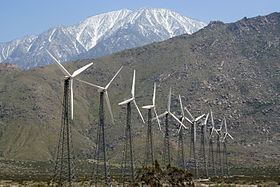
The San Gorgonio Pass area tends to get snow at least once or twice during the winter months, although it rarely sticks to hard surfaces, such as the freeway or city streets. The most famous sight on San Gorgonio Pass is the San Gorgonio Pass Wind Farm on its eastern slope, as it marks the gateway into the Coachella Valley. (The pass is one of the windiest places in Southern California.) Also nearby are the Cabazon Dinosaurs on the north side of the freeway from Cabazon.