
Basin size 467 sq mi (1,210 km) Basin area 1,210 km² | Length 204 km Country United States of America | |
 | ||
Bridges West Jefferson Avenue–Rouge River Bridge Cities | ||
The Rouge River is a 127 mile river in the Metro Detroit area of southeastern Michigan. It flows into the Detroit River at Zug Island, which is the boundary between the cities of River Rouge and Detroit.
Contents
- Map of Rouge River Michigan USA
- Physical and natural aspectsEdit
- Main branchEdit
- Upper branchEdit
- Middle branchEdit
- Lower branchEdit
- Eliza Howell ParkEdit
- Fair LaneEdit
- The Henry Ford and Greenfield VillageEdit
- Rouge River Bird ObservatoryEdit
- Rouge River Gateway Greenway TrailEdit
- River Rouge ParkEdit
- Other notable parks and recreation areasEdit
- References
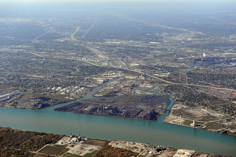
Map of Rouge River, Michigan, USA
The river's roughly 467-square-mile (1,210 km2) watershed includes all or parts of 48 municipalities, with a total population of over 1.35 million and drains a large portion of central and northwest Wayne County, as well as much of southern Oakland County and a small area in eastern Washtenaw County. Nearly the entire drainage basin is in urban and suburban areas, with areas of intensive residential and industrial development. Still, more than 50 miles (80 km) of the River Rouge flow through public lands, making it one of the most accessible rivers in the state.
Until recently the river was heavily polluted, and in 1969 even caught fire. The passage of the Clean Water Act in 1972 made it unlawful to discharge any pollution from a point source into navigable waters and the EPA's National Pollution Discharge Elimination Program was created to regulate these discharges. In 1986, a non-profit organization of concerned citizens called Friends of the Rouge was formed and began organizing an annual cleanup called Rouge Rescue to raise awareness about the need to clean up the Rouge. In 1987, the entire watershed was designated a Great Lakes Area of Concern under the Great Lakes Water Quality Agreement and nine Beneficial Use Impairments were identified. In 1992, a massive project called the Rouge River National Wet Weather Demonstration Project was implemented and further cleanup measures are ongoing. The Alliance of Rouge Communities is an organization of governmental and non-governmental entities created in 2006 to manage the watershed.
Physical and natural aspectsEdit
The River Rouge totals 127 miles (204 km) in length and is divided into four branches, the main, upper, middle, and lower branches. The upper branch flows into the main branch in northwest Detroit, just east of Redford Township. The middle branch enters the main branch in Dearborn Heights just north of the boundary with Dearborn. The lower branch joins less than two miles (3 km) downstream in Dearborn.
The lower 1.5 miles (2.4 km) of the river south of Michigan Avenue were channelized, widened, and dredged to allow freighter access to Ford's River Rouge Plant inland factory facilities. The plant was built between 1915 and 1927, when it was the first manufacturing facility for automobiles that included within the plant virtually everything needed to produce the cars: blast furnaces, an open hearth mill, a steel rolling mill, a glass plant, a huge power plant and an assembly line.
Main branchEdit
The headwaters of the main branch rise in the southwest corner of Rochester Hills and the northeast corner of Bloomfield Township. It flows mostly south through the western part of Troy, and then flows southwest through Birmingham, a noncontiguous portion of Bloomfield Township, Beverly Hills, the southeast corner of Bingham Farms, and Southfield. It then flows mostly south through western Detroit and Dearborn Heights, then turns southeast in Dearborn and continues along the northern edges of Allen Park, Melvindale, River Rouge and the southern edge of Detroit. Other municipalities that are part of the main branch watershed are Auburn Hills, Bloomfield Hills, Farmington, Farmington Hills, Franklin, Lathrup Village, Oak Park, Orchard Lake, Pontiac, Southfield Township, and West Bloomfield Township.
Major tributaries of the main branch include:
Upper branchEdit
The headwaters of the upper branch rise in southwestern West Bloomfield Township, the southeast corner of Commerce Township, and the northeast corner of Novi. It forms in Farmington Hills with the confluence of Minnow Pond Drain and Seeley Drain, where it flows mostly southeast through Farmington, Livonia, Redford Township and enters the main branch in the northwest Detroit neighborhood of Brightmoor, Detroit.
Tributaries of the upper branch include (from downriver to upriver)
Middle branchEdit
The middle branch forms in Northville in northwest Wayne County with the confluence of the "Walled Lake branch" and Johnson Drain. The Walled Lake branch rises in Novi in a marshy drainage area south of Walled Lake, in southwest Oakland County. Johnson Drain rises in Salem Township in northeast Washtenaw County. From Northville, the middle branch flows south through Northville Township and Plymouth Township before turning to the southeast in the city of Plymouth. From Plymouth, it continues through the southwest corner of Livonia into Westland, then along the northern edge of Garden City and into Dearborn Heights where it merges with the main branch near the southern boundary with Dearborn. Other municipalities that are part of the middle branch watershed are Canton Township, Commerce Township, Farmington, Farmington Hills, Lyon Township, Redford Township, and Wixom.
Tributaries of the middle branch include (from downriver to upriver)
Lower branchEdit
The lower branch rises in sections 11 and 12 in Superior Township in Washtenaw County and flows mostly eastward into Wayne County through Canton Township, Wayne, Westland, Inkster, Dearborn Heights and Dearborn before joining the main branch. Other communities in the lower branch watershed include Van Buren Township, Plymouth Township, Salem Township, Ypsilanti Township.
Tributaries include (from downriver to upriver):
Eliza Howell ParkEdit
The 250-acre (100 ha) Eliza Howell Park includes 138 acres (56 ha) donated to the city in 1936. The city stopped mowing the park and 137 others in the spring of 2009. The grandson of the original benefactor is suing the city for the return of the land because they have violated the origin deed.
Fair LaneEdit
Henry Ford built an estate, Fair Lane, on the river in Dearborn, upriver from the manufacturing plant, on what is now the campus of the University of Michigan–Dearborn. The estate is a now a National Historic Landmark. The master plan and gardens were designed by landscape architect Jens Jensen. A portion of the estate's grounds are a preserved historic landscape and more of it is held as a nature study area since 1956. The residence is now a museum and open to the public.
The Henry Ford and Greenfield VillageEdit
The Henry Ford, billed as "America's Greatest History Attraction", is a major tourist destination in the area including Greenfield Village. Greenfield Village was opened in 1929 to preserve historic landmarks, including Noah Webster’s House, Thomas Edison’s Menlo Lab and the garage where Henry Ford built the Quadricycle, his first car.
Rouge River Bird ObservatoryEdit
Since 1992 the Rouge River Bird Observatory has operated on the campus of University of Michigan-Dearborn.
Rouge River Gateway Greenway TrailEdit
The trail has access points from Michigan Avenue in Dearborn, from Fair Lane and from the University of Michigan Dearborn campus. There is an aspiration to develop the greenway trail all the way to the Detroit River.
River Rouge ParkEdit
River Rouge Park is a 1,184-acre (479 ha) park purchased by the city of Detroit in the 1920s. Its boundary is formed by the railway to the north and West Warren to the south and by Outer Drive, West Parkway and Parkland on the west and Trinity and Burt Road on the east. In July 2014, two Olympic-sized pools and a bath house were reopened at Rouge Park as part of a $5.5 million park renovation project. River Rouge Park, is the city’s largest park, and larger than Belle Isle State Park, at 982 acres.