
 | ||
Similar Basin and Range Province, Valles Caldera, Bandelier National Monument, San Luis Valley, Sandia Mountains | ||
Rio grande rift project jenny nakai
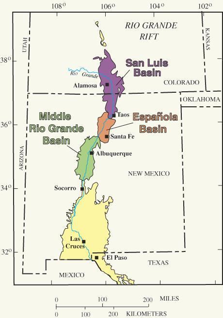
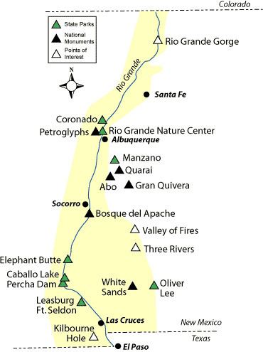
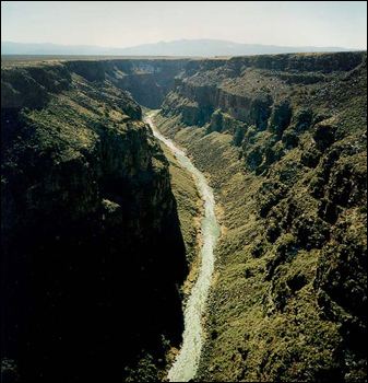
The Rio Grande Rift is a north-trending continental rift zone. It separates the Colorado Plateau in the west from the interior of the North American craton on the east. The rift extends from central Colorado in the north to the state of Chihuahua, Mexico in the south. The rift zone consists of four basins that have an average width of 50 kilometers. The rift can be observed on location at Rio Grande National Forest, White Sands National Monument, Santa Fe National Forest, and Cibola National Forest, among other locations.
Contents
The Rio Grande Rift has been an important site for humans for a long time, because it provides a north-south route that follows a major river. The Rio Grande follows the course of the rift from southern Colorado to El Paso, where it turns southeast and flows toward the Gulf of Mexico. Important cities, including Albuquerque, Santa Fe, Taos, Española, Las Cruces, El Paso, and Ciudad Juárez lie within the rift.
Geology
The Rio Grande Rift represents the easternmost manifestation of widespread extension in the western U.S. during the past 35 million years. The rift consists of three major basins and many smaller basins, less than 100 km2. The three major basins (from northernmost to southernmost) are the San Luis, Española, and Albuquerque basins. Further south, the rift is defined by a network of smaller, less topographically distinct alternating basins and ranges. The distinction between these smaller basins and those of the Basin and Range Province becomes blurred in northern Mexico.
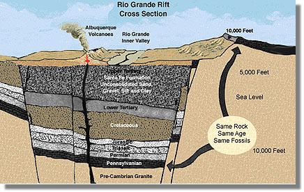
Basin size generally decreases to the north in the rift, where the Española covers approximately 120 km north-south and 40 km east-west, and the San Luis is roughly 120 km by 80 km. These basins may contain smaller units within them, such as the Alamosa basin within the San Luis, which is bounded by the San Juan and Tusas mountains on the west and the Sangre de Cristo Mountains in the east. The Albuquerque basin is the largest of the three basins, spanning 160 km north-south and 86 km east-west at its widest points. It is the oldest of the three major basins, and contains 7,350 m of Paleogene clastic sediments deposited on Precambrian basement. The southernmost Albuquerque basin contains pre-rift volcanic deposits, while the central and northern portions contain volcanics erupted during rifting.
The southernmost Rio Grande Rift broadens, becoming more complex in structure and physiographically indistinguishable from the adjoining Basin and Range province.
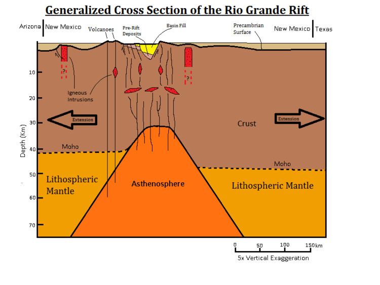
In cross-section, the geometry of the basins within the rift are asymmetrical half-grabens, with major fault boundaries on one side and a downward hinge on the other. Which side of the basin has the major fault or the hinge alternates along the rift. The alternation between these half-grabens occurs along transfer faults, which trend across the rift to connect the major basin-bounding faults and occur between basins or, in places, within basins. The Precambrian basement changes relief sharply in this area, from 8,700 m below sea level at the bottom of the Albuquerque basin to 3,300 m above sea level in the nearby Sandia Mountains, which flanks the Albuquerque basin to the east. Flanking mountains are generally taller along the east side of the rift (although some of this relief may be Laramide in origin). The thickness of the crust increases to the north beneath the rift, where it may be as much as 5 km thicker than it is in the south. The crustal thickness underneath the rift is on average 30–35 km, thinner by 10–15 km than the Colorado Plateau on the west and the Great Plains to the east.
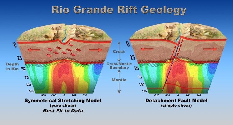
The rift is presently nearly tectonically quiescent, but significant deformation and faulting with offsets of many kilometers were responsible for its formation starting about 35 Ma. The largest-scale manifestation of rifting involves a pure-shear rifting mechanism, in which both sides of the rift pull apart evenly and slowly, with the lower crust and upper mantle (the lithosphere) stretching like taffy. This extension is associated with very low seismic velocities in the upper mantle above approximately 400 km depth associated with relatively hot mantle and low degrees of partial melting. This intrusion of the asthenosphere into the lithosphere and continental crust is thought to be responsible for nearly all of the volcanism associated with the Rio Grande rift.
The sedimentary fill of the basins consists largely of alluvial fan and mafic volcanic flows. The most alkalic lavas erupted outside the rift. The sediments that were deposited during rifting are commonly known as the Santa Fe Group. This group contains sandstones, conglomerates, and volcanics. Aeolian deposits are also present in some basins.
The Rio Grande Rift is intersected in northern New Mexico by the NE-SW trending Jemez Lineament which extends well into Arizona, defined by aligned volcanic fields and several calderas in the area, including the Valles Caldera National Preserve in the Jemez Mountains. The significance of the Jemez Lineament is unclear; it is not obviously related to the formation of the Rio Grande rift, but may be a hotspot trail. Also on the Colorado Plateau but further north lies the San Juan volcanic field in the San Juan Mountains of Colorado.
The youngest eruptions in the rift region are in the Valley of Fires, New Mexico and are approximately 5,400 years old. The Socorro, New Mexico region of the central rift hosts an inflating mid-crustal sill-like magma body at a depth of 19 km that is responsible for anomalously high earthquake activity in the vicinity, including the largest rift-associated earthquakes in historic times (two events of approximately magnitude 5.8) in July and November 1906. Earth and space-based geodetic measurements indicate ongoing surface uplift above the "Socorro Magma Body". at approximately 2 mm/year.
.
Geologic history
The Rio Grande rift's tectonic evolution is fairly complex. The fundamental change in the western margin of the North American plate from one of subduction to a transform boundary occurred during Cenozoic time. The Farallon plate continued to be subducted beneath western North America for at least 100 million years during Late Mesozoic and early Cenozoic time. Compressional and transpressional deformation incurred by the Laramide Orogeny lasted until about 40 Ma in New Mexico. This deformation may have been a result of the coupling between the subducting Farallon plate and the overlying North American plate. Crustal thickening occurred due to Laramide compression. After the Laramide Orogeny and until 20 Ma, a major period of volcanic activity occurred throughout the southwestern United States. Injection of hot magmas weakened the lithosphere and allowed for later extension of the region.
Cenozoic extension started about 30 million years ago (Ma). There are two phases of extension observed: late Oligocene and middle Miocene. The first period of extension produced broad, shallow basins bounded by low-angle faults. The crust may have been extended as much as 50% during this episode. Widespread magmatism in mid-Cenozoic time suggests that the lithosphere was hot, the brittle-ductile transition was relatively shallow. There is evidence that the second period of extension began earlier in the central and northern Rio Grande Rift than in the south.
It has been suggested that the Colorado Plateau acts as a semi-independent microplate and one way of explaining the creation of the Rio Grande Rift is by the simple rotation of the Colorado Plateau 1-1.5 degrees in a clockwise direction relative to the North American craton.