
Country United States County Clinton Incorporated (borough) 1860 Elevation 204 m Population 1,237 (2013) Area code 570 | Settled 1825 Time zone Eastern (EST) Zip code 17764 Local time Monday 5:40 PM | |
 | ||
Weather 18°C, Wind W at 8 km/h, 60% Humidity Area 2.927 km² (2.927 km² Land / 1 ha Water) | ||
Renovo is a borough in Clinton County, Pennsylvania, 28 miles (45 km) northwest of Lock Haven. In 1900, 4,082 people lived there, and in 1910, 4,621 lived there, but in the 2010 census the borough population was 1,228.
Contents
- Map of Renovo PA 17764 USA
- Geography
- Demographics
- Points of interest
- Telecommunications
- Notable people
- References
Map of Renovo, PA 17764, USA
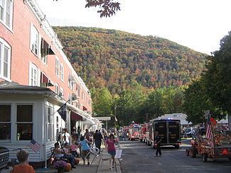
The borough is located on the West Branch Susquehanna River, and along Pennsylvania's Bucktail State Park Natural Area, centered on Pennsylvania Route 120, which winds through the surrounding mountains following the river. The town is the home of the "Flaming Foliage Festival" held each October, generally in the second weekend, celebrating the fall colors of the trees on the area's many mountains. The festival includes a parade and the crowning of a queen, usually chosen from one of the nearby high schools. The festival serves as a "homecoming" event for former residents of Renovo, many of whom return annually for the event. Various vendors from the surrounding areas sell food, clothing, and an array of novelties, memorabilia, and souvenirs.
The economy of Renovo and the surrounding area had been primarily based on lumbering, until the first-growth forest was almost entirely stripped away, and the industry collapsed. There are also deposits of bituminous coal and fire clay in the region.
Renovo was built for and by the Philadelphia & Erie Railroad as the midpoint between Philadelphia and Erie. The town was laid out on a mostly-flat "flood plain" along the West Branch of the Susquehanna River in North-Central Pennsylvania and incorporated in 1866. Many of the buildings which came to constitute what eventually became a sprawling Railroad Shops complex were built before, during, and after the American Civil War. The Philadelphia and Erie Railroad, along with many other relatively smaller lines eventually became incorporated into the Pennsylvania Railroad. The Pennsylvania Railroad was the largest corporation in the world with an annual GPO larger than the Federal Government and is the only corporation in history to have paid out dividends due to its profitability for 100 years. Unlike most "rural" towns and residential areas, Renovo was laid out in an industrially-oriented urban grid with avenues given names of the Great Lakes and "side streets" numbered from 1 to 16. Houses were mostly built close to one another or incorporated into "row houses." Houses with larger lots, allowing for big yards were a rare luxury. History shows that, before the town was completely built out, Renovo was known and advertised as a "resort town in the mountains." One can still find newspaper ads and brochures extolling the restorative mountain air, clean water, and outdoor activities such as fishing and hunting. There were several large hotels in the town well before the turn of the 20th century. The Railroad made access to this remote area seemingly quick and effortless for those living in other cities which enjoyed railroad service. The town boasted dozens of bars and restaurants as well as fine churches which gave testimony to the forward-directed, optimistic, and vigorous energy which fueled the town's growth and development. Just about every institution one would find in a town of the era or today such as medical personnel, hospital, YMCA, grade, middle, and high schools, taxi service, shops, clubs, lodges, fraternal organizations, professional services, sports teams, were established. The major employer, of course, was the Pennsylvania Railroad and Pennsylvania Railroad Shops. As long as the Railroad prospered, the town was a bustling and humming hive of human activity. Some aspects of Railroad business began to decrease as early as before World War II but business surged back strongly during the War. However, further decline in demand for both passenger and freight transportation via the Railroad was to return in the form of the building of the St. Lawrence Seaway, the building of the Interstate Highway System, the surge of automobile ownership and use,and the consolidation of the Pennsylvania Railroad's Shop facilities to other locations such as Pittsburgh and Altoona. The closing of the shops in the 1960s tolled the death knell for Renovo as an enterprising town with a future. It's present population is less than 2,000 where it was once around 5,000. Many residents drive the two-lane, windy roads and I-80 to other towns for employment. There is also a substantial contingent of lifelong residents and transplants who are retired. The change in human activity over the years hasn't dimmed or substantially altered the natural beauty of this Allegheny Mountain area of the larger Appalachian Highlands.
Geography
Renovo is located in north-central Clinton County at 41°19′43″N 77°44′54″W (41.327669, -77.749580), along the West Branch Susquehanna River, at the bottom of a 1,000-to-1,200-foot-deep (300 to 370 m) gorge. South Renovo is directly across the river, on the south bank.
According to the United States Census Bureau, Renovo has a total area of 1.13 square miles (2.93 km2), of which 1.13 square miles (2.92 km2) is land and 0.004 square miles (0.01 km2), or 0.48%, is water.
Pennsylvania Route 120 passes through the borough, leading southeast (downriver) 28 miles (45 km) to Lock Haven, the county seat, and west then northwest up Sinnemahoning Creek and its tributaries 45 miles (72 km) to Emporium. Pennsylvania Route 144 crosses the West Branch from Renovo into South Renovo and leads southwest 35 miles (56 km) to Snow Shoe and Interstate 80. PA 144 leads north 44 miles (71 km) to Galeton on U.S. Route 6.
Airports and distances from Renovo:
Demographics
As of the census of 2000, there were 1,318 people, 593 households, and 333 families residing in the borough. The population density was 1,136.0 people per square mile (438.7/km²). There were 727 housing units at an average density of 626.6 per square mile (242.0/km²). The racial makeup of the borough was 98.94% White, 0.23% African American, 0.08% Native American, 0.08% Pacific Islander, and 0.68% from two or more races. Hispanic or Latino of any race were 0.38% of the population.
There were 593 households, out of which 29.0% had children under the age of 18 living with them, 35.4% were married couples living together, 15.0% had a female householder with no husband present, and 43.7% were non-families. 38.3% of all households were made up of individuals, and 21.8% had someone living alone who was 65 years of age or older. The average household size was 2.22 and the average family size was 2.94.
In the borough the population was spread out, with 25.9% under the age of 18, 8.0% from 18 to 24, 24.3% from 25 to 44, 21.9% from 45 to 64, and 20.0% who were 65 years of age or older. The median age was 40 years. For every 100 females there were 93.0 males. For every 100 females age 18 and over, there were 87.7 males.
The median income for a household in the borough was $18,636, and the median income for a family was $23,854. Males had a median income of $26,328 versus $16,429 for females. The per capita income for the borough was $11,709. About 25.7% of families and 30.2% of the population were below the poverty line, including 50.8% of those under age 18 and 12.0% of those age 65 or over.
Points of interest
Renovo is in the heart of the Pennsylvania Wilds which comprises twelve and a half counties (Warren, McKean, Potter, Tioga, Forest, Elk, Cameron, Clinton, Lycoming, Clarion, Jefferson, Clearfield and part of Centre) located in north-central Pennsylvania. This area contains over two million acres of remote, mountainous, and pristine lands located on state forest lands, state game lands, state park lands and public grounds that offer a wide variety of recreational opportunities. The Wilds has within it 29 state parks, 8 state forests, 50 state game lands, abundant wildlife, several natural/wild areas, and miles of hiking trails and fishing streams. This region also contains the largest elk herd in the Northeast, stretching as far west as Ridgway and as far east as Renovo.
Telecommunications
In 2011, Immix Wireless rolled out 2.75G (EDGE) wireless GSM services in Renovo. Immix was the first to roll out a cellular service in Renovo. Before this, only wired internet and phone services were available in Renovo through Comcast and Verizon Communications.