
Elevation 3,129 m | Prominence 84 m | |
 | ||
Easiest route from Col du Fréjus, punta del Fréjus and W ridge Similar Pointe du Fréjus, Aiguille de Scolette, Pointe de Paumont, Mont Thabor, Rocca Bernauda | ||
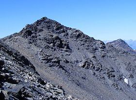
Punta Bagnà (in Italian) or Cime du Grand Vallon (in French) is a mountain of Savoie, France and of the Province of Turin, Italy. It lies in the Cottian Alps range. It has an elevation of 3,129 metres above sea level.
Contents
Map of Punta Bagn%C3%A0, 73500 Avrieux, France
Etymology
The name used on the Italian maps comes from Piedmontese "Bagnà" («wet»), which should derive from the look of the blackish fine ground nearby the summit. The French name comes from the "Grand Vallon", a secondary valley which starts from the mountain and goes northwards towards Charmaix and Modane.
Geography
In the French subdivision of western Alps it belongs to the Massif du Mont-Cenis while in the SOIUSA (International Standardized Mountain Subdivision of the Alps) it is part of the mountain group called "gruppo della Pierre Menue" (Italian) or "groupe de l'Aiguille de Scolette" (French).
Administratively the mountain is divided between the Italian comune of Bardonecchia (southern face) and the French communes of Modane (north-western face) and Avrieux (north-eastern face).
Access to the summit
The easiest route for the summit starts from col du Fréjus, which connects Modane and Bardonecchia, then passes by punta del Fréjus and follows the south-western ridge of the mountain.