
Elevation 3,171 m | Prominence 378 m Parent peak Aiguille de Scolette | |
 | ||
Listing Alpine mountains above 3000 m Easiest route from Pelouse pass (E ridge) or Roccia Verde pass (S ridge) Similar Aiguille de Scolette, Punta Bagnà, Jôf Fuart, Rocca Bernauda, Pointe du Fréjus | ||
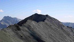
Pointe de Paumont (in French) or Cima del Vallone (in Italian) is a mountain of Savoie, France and of the Province of Turin, Italy. It lies in the Cottian Alps range. It has an elevation of 3,171 metres above sea level.
Contents
Map of Pointe de Paumont, 73500 Avrieux, France
Etymology
Paumort, the name used on French maps, should come from a toponym used on the Italian side of the mountain (croce di Paumont, rio di Paumont), which derives from Piedmontese "pàu mòrt" («fear of death»).
Geography
In the French subdivision of Western Alps it belongs to the Massif du Mont-Cenis while in the SOIUSA (International Standardized Mountain Subdivision of the Alps) it' the highest mountain of a subgroups (STG) called Crête Grand Vallon-pointe du Fréjus ( Fr) or Cresta Gran Vallone-punta del Fréjus (It) - code:I/A-4.III-B.5.a.
Administratively the mountain is divided between the commune of Avrieux (F, north face) and the comune of Bardonecchia (I, south-western and south-eastern faces).
Access to the summit
The easiest route for the summit starts from Pelouse's pass, which connects Avrieux and Bardonecchia, and follows the eastern ridge of the mountain passing by Cime Gardoria/Cima Gardiola (3,137 m). Other two routes, roughly of the same climbing grade, follow the other two ridges which meet on the mountain's summit: the southern one from Roccia Verde pass and the northwestern one from Punta Bagnà.