
Elevation 638 m (2,093 ft) Lowest elevation 0 m (0 ft) Area 1,292 km² Population 40,900 (2003) | Highest elevation 1,276 m (4,186 ft) Climate Af Local time Wednesday 3:36 PM Number of airports 1 | |
 | ||
Weather 30°C, Wind NW at 18 km/h, 72% Humidity | ||
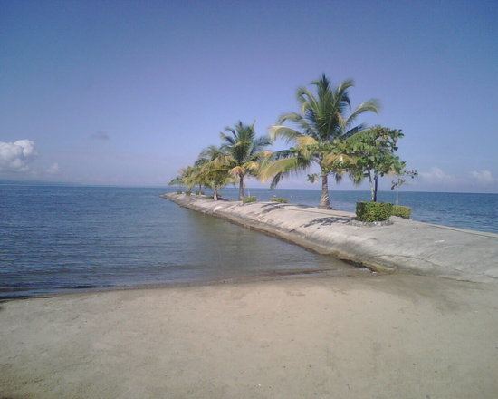
Amatique bay resort marina puerto barrios izabal guatemala x
Puerto Barrios ([ˈpweɾ.to ˈβa.rjos]) is a city in Guatemala, located within the Gulf of Honduras. The bay in which the harbour is located is called Bahia de Amatique. Puerto Barrios is the departmental seat of Izabal department and is the administrative seat of Puerto Barrios municipality.
Contents
- Amatique bay resort marina puerto barrios izabal guatemala x
- Map of Puerto Barrios Guatemala
- Road from puerto barrios to guatemala city march 2013
- History
- Construction of Atlantic Highway and Santo Tomas de Castilla Harbor
- The New Adventures of Tarzan 1935
- Climate
- Geographic location
- Government and infrastructure
- Famous People From Puerto Barrios
- References
Map of Puerto Barrios, Guatemala
It is Guatemala's main Caribbean Sea port, together with its more modern twin port town just to the southwest, Santo Tomás de Castilla. In 2003 the estimated population of Puerto Barrios was 40,900 people. Puerto Barrios is located 297 kilometers (185 mi) northeast of Guatemala City. It is the terminus of Highway CA9 which begins at the Pacific port city of Puerto San José and traverses the country through Guatemala City.
The city's population is a mix of mostly Afro-Guatemalans, Maya, Afro-Caribbean (such as Afro-Jamaicans), and other West Indian groups. Its heyday was in the latter 19th and early 20th centuries, following the construction of a railroad connecting large banana and coffee plantations with the shipping docks, all controlled by the International Railways of Central America and The Great White Fleet, both owned by the United Fruit Company.
Puerto Barrios is divided by many neighborhoods or Barrios such as El rastro, las champas, los tanques, la veinte, la veintedos, la catorce, la trece, and el estrecho. Although the town is small, due to its harbor nature, many of its visitors are ship workers who frequent the night entertainment centers throughout the town.
Puerto Barrios is starting to get more visitors in the new century as the nearby town of Santo Tomás de Castilla has started receiving cruise ships. Puerto Barrios Airport is currently being refurbished in order to receive scheduled flights in the near future.
Among the many nearby tourist attractions are the Mayan ruins of Quirigua. The Castillo de San Felipe de Lara, an old Spanish fort in Río Dulce, guards the entrance to Lake Izabal. Another popular attraction is the lively town of Livingston where Garifuna culture can be experienced, with its Punta and Yankunu dances.
Road from puerto barrios to guatemala city march 2013
History
In 1883, then president general Justo Rufino Barrios had the plan to connect Guatemala City to a port in the Atlanic shore thru a railroad in order to be able to move the coffee produced by his own haciendas and those of his liberal partners; therefore, on 4 August 1883, he issued a decree in which a person with a salary of more than 4 pesos a month could pay 4 pesos a year over a 10-year span to finance the railroad. However, after the untimely death of Barrios in the Battle of Chalchuapa in 1885, this plan was forgotten by his successor, general Manuel Lisandro Barillas.
It was not until 1892, when José María Reyna Barrios assumed power, that the railroad project was restarted. On 19 July 1895, Reina Barrios issued executive action #513, which established that a city was to be founded between the Escondido and Estrecho rivers, to be called Puerto Barrios. The ceremonial act of foundation took place on 5 December 1892. A part of the Northern Railroad project, executive action #524 declared Puerto Barrios to be a "Major port of the Republic" and ordered the customs offices previously based in Livingston to be relocated there.
Given that in those days most visitors arriving from Europe and North America arrived at the port on the Caribbean Sea shore, Reina Barrios pushed for the Northern Railroad to be finished on time. Not only was the railroad vital for the Expo success, it was key to move merchandise and passengers between the Caribbean Sea and the new Port of Iztapa on the Pacific shore. Reina Barrios hoped the railroad would improve the progress and development of the country given that the United States and Spain were still at war over Cuba, and it was evident that a dependable interoceanic communication line was crucial for the North American country. Completing a transoceanic railway was a main objective of Reina Barrios' government, with a goal to attract international investors at a time when the Panama Canal was not built yet. However, a sharp decline in the price of coffee and silver, along with the high technical difficulties of the railroad construction close to Guatemala City −mainly due to the steep cliffs and mountains around the city− resulted in the collapse of Guatemala's economy, a failure of the Exposición Centroamericana, and the eventual assassination of Reina Barrios, on 8 February 1898.
After Reina Barrios' death, civilian lawyer Manuel Estrada Cabrera was designated as president and inherited an enormous external debt to British banks, which forced him to search for an ally in the United States. In 1900, Estrada Cabrera authorized his Secretary of Economy, Rafael Spínola, to contract an American company, Central American Improvement Co. Inc., to finish the Northern Railroad and fix those stretches that were in disrepair on the rest of the line. To cover the expenses, the Guatemalan government gave a concession to the American company to use the railroad along with all of its facilities without any cost; this included the port and dock in Puerto Barrios, for which the Guatemalan people and government had to pay fees for their use.
Finally, in 1904, knowing the pro-American attitude of Estrada Cabrera, Minor Keith partners, began to get concession on railroads of both Guatemala and El Salvador, and in that year, International Railways of Central American (IRCA) was incorporated in New Jersey.; the harbor was then partly built by Theodore Roosevelt's Corps of Engineers in 1906–1908. Eventually, United Fruit Company, owner of IRCA, controlled Puerto Barrios completely, as it owned the docks, the railroads, the banana production from Izabal and even the merchant fleet: the Great White Fleet.
This situation remained as such until the government of Colonel Jacobo Árbenz Guzmán (1951–1954), who decided to build a highway and another port – Santo Tomas de Castilla – to compete with the American fruit company. He also issued an Agrarian Reform that impacted UFCO land. Eventually, Árbenz was accused of Communism and was ousted in 1954, but the highway was almost completed and was completed by his successor, colonel Carlos Castillo Armas. Just as Arbenz had hoped, IRCA's last profit was reported in 1957.
The earthquake on 4 February 1976, one of the worst in Guatemala's history, destroyed most of the port facilities of Puerto Barrios, and most modern cargo traffic moved to its twin port in Santo Tomás de Castilla. In the 21st century, Puerto Barrios remains an important hub for Dole and Fresh Del Monte Produce industries, which are what remains from United Fruit Company.
Construction of Atlantic Highway and Santo Tomas de Castilla Harbor
In order to establish the necessary physical infrastructure to make possible the "independent" and national capitalist development that could reduce the extreme dependence on the United States and break the American monopolies operating in the country, president Jacobo Árbenz and his government began the planning and construction of the Atlantic Highway, which was intended to compete with the monopoly on land transport exerted by the United Fruit Company, through one of its subsidiaries: the International Railways of Central America (IRCA), which had the concession since 1904, when it was granted by then president Manuel Estrada Cabrera. Construction of the highway began by the Roads Department of the Ministry of Communications, with the help of the military engineering battalion. It was planned to be built parallel along the railway line, as much as possible. The construction of the new port was also aimed to break another UFCO monopoly, since Puerto Barrios was owned and operated solely by The Great White Fleet, another UFCO subsidiary.
The New Adventures of Tarzan' (1935)
In 1935, the film The New Adventures of Tarzan, was filmed on location in Guatemala, taking advantage of the help from the United Fruit Company and president Jorge Ubico. The places where the filming was made were:
Climate
Puerto Barrios has a tropical rainforest climate (Köppen: Af).
Geographic location
The municipality's elevation varies from level at Punta de Manabique to 1276 m above sea level at Cerro San Gil. The municipal capital is located on the shore of Santo Tomás internal bay, which is part of Amatique Bay. There is a small peninsula called Punta de Manabique which separates the small bay from the Gulf of Honduras, and shelters it from storms.
Government and infrastructure
There is a prison in the city with an official capacity of 175 prisoners. As of 2016, it has over 900 prisoners, making it over capacity.