
Established 1776 Climate Cwb Population 1.022 million (2001) | Department Guatemala Elevation 1,500 m (4,900 ft) Local time Saturday 3:17 AM | |
 | ||
Weather 16°C, Wind N at 18 km/h, 91% Humidity Points of interest | ||
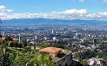
Guatemala city
Guatemala City (Spanish: Ciudad de Guatemala), locally known as Guatemala or Guate, is the capital and largest city of the Republic of Guatemala, and the most populous in Central America. The city is located in the south-central part of the country, nestled in a mountain valley called Valle de la Ermita (English: Hermitage Valley). In 2009, it had a population of 1,075,000. Guatemala City is also the capital of the local Municipality of Guatemala and of the Guatemala Department.
Contents
- Guatemala city
- Map of Guatemala City Guatemala
- Guatemala 01 guatemala city
- History
- Contemporary times
- Structure and growth
- Population
- Communications
- Economy and Finance
- Places of interest by zones
- Transportation
- Universities and schools
- Sports
- International organizations with headquarters in Guatemala City
- Twin towns sister cities
- Climate
- Volcanic activity
- Earthquakes
- Mudslides
- Piping pseudokarst
- Geographic location
- References
Map of Guatemala City, Guatemala
Guatemala 01 guatemala city
History
Human settlement on the present site of Guatemala City began with the Maya who built a city at Kaminaljuyu. The Spanish colonists established a small town, which was made a capital city in 1775. At this period the Central Square with the Cathedral and Royal Palace were constructed. After Central American independence from Spain the city became the capital of the United Provinces of Central America in 1821.
The 19th century saw the construction of the monumental Carrera Theater in the 1850s, and the Presidential Palace in the 1890s. At this time the city was expanding around the 30 de junio Boulevard and elsewhere, displacing native settlements from the ancient site. Earthquakes in 1917–1918 destroyed many historic structures. Under Jorge Ubico in the 1930s a hippodrome and many new public buildings were constructed, although peripheral poor neighborhoods that formed after the 1917–1918 earthquakes continued to lack basic amenities.
During the Guatemalan Civil War, terror attacks beginning with the burning of the Spanish Embassy in 1980 led to severe destruction and loss of life in the city. In May 2010 two disasters struck: the eruption of the Pacaya volcano, and two days later Tropical Storm Agatha.
Contemporary times
Guatemala City serves as the economic, governmental, and cultural epicenter of the nation of Guatemala. The city also functions as Guatemala's main transportation hub, hosting an international airport, La Aurora International Airport, and serving as the origination or end points for most of Guatemala's major highways. The city, with its robust economy, attracts hundreds of thousands of rural migrants from Guatemala's interior hinterlands and serves as the main entry point for most foreign immigrants seeking to settle in Guatemala.
In addition to a wide variety of restaurants, hotels, shops, and a modern BRT transport system (Transmetro), the city is home to many art galleries, theaters, sports venues and museums (including some fine collections of Pre-Columbian art) and provides a growing number of cultural offerings. Guatemala City not only possesses a history and culture unique to the Central American region, it also furnishes all the modern amenities of a world class city, ranging from an IMAX Theater to the Ícaro film festival (Festival Ícaro), where independent films produced in Guatemala and Central America are debuted.
Structure and growth
Guatemala City is subdivided into 22 zones designed by the urban engineering of Raúl Aguilar Batres, each one with its own streets and avenues, making it pretty easy to find addresses in the city. Zones are numbered 1-25 with Zones 20, 22 and 23 not existing as they would have fallen in two other municipalities territory. Addresses are assigned according to the street or avenue number, followed by a dash and the number of metres it is away from the intersection further simplifying address location. The zones are assigned in a spiral form starting in downtown Guatemala city.
The city's metro area has recently grown very rapidly and has absorbed most of the neighboring municipalities of Villa Nueva, San Miguel Petapa, Mixco, San Juan Sacatepequez, San José Pinula, Santa Catarina Pinula, Fraijanes, San Pedro Ayampuc, Amatitlán, Villa Canales, Palencia and Chinautla forming what is now known as the Guatemala City Metropolitan Area.
Zone One is the Historic Center, (Centro Histórico), lying in the very heart of the city, the location of many important historic buildings including the Palacio Nacional de la Cultura (National Palace of Culture), the Metropolitan Cathedral, the National Congress, the Casa Presidencial (Presidential House), the National Library and Plaza de la Constitución (Constitution Plaza, old Central Park). Efforts to revitalize this important part of the city have been undertaken by the municipal government and have been very successful thus far.
In an attempt to control rapid growth of the city, the municipal government (Municipalidad de Guatemala) headed by longtime Mayor Álvaro Arzú, has implemented a plan to control its growth based on transects along its important arterial roads and exhibitting Transit-oriented development (TOD) characteristics. This plan denominated POT (Plan de Ordenamiento Territorial) aims to allow taller building structures of mixed uses to be built next to large arterial roads and gradually decline in height and density as you move away from such. It is also worth mentioning, that due to the Airport being in the city, to the south, many Aeronautic Height Limits have been applied to the construction code. This limits the maximum height for a building, at 60 metres (200 feet) in Zone 10, up to 95 metres (312 feet) in Zone 1.
The city is located in the South-Central area of the country and has a lot of green areas. Besides the parks, the city offers a portfolio of entertainment in the region, focused on the so-called Zona Viva and the Calzada Roosevelt as well as four degrees North. The activity of Casinos is considerable and possesses several located in different parts of the Zona Viva, although East market is still in the stage of initiation, although the date has been restructuring this area and is becoming more modern.
One of the most outstanding mayors was the engineer Martin Prado Vélez, who took over in 1949, and ruled the city during the reformist Presidents Juan José Arévalo and Jacobo Arbenz Guzman, although he was not a member of the ruling party at the time and was elected due his well-known capabilities. Of cobanero origin, married with Marta Cobos, he studied at the University of San Carlos; under his tenure, among other modernist works of the city, it was planned the El Incienso bridge, the construction of the Roosevelt Avenue, the main road axis from East to West of the city, the town hall building, and numerous road works which meant the widening of the colonial city, its order in the cardinal points and the generation of a ring road with the first Shamrock in the main city of Central America.
In the financial district are the tallest buildings in the country including: Club Premier, Tinttorento, Atlantis building, Atrium, Tikal Futura, Building of Finances, Towers Building Batteries, Torres Botticelli, Tadeus, building of the INTECAP, Royal Towers, Towers Geminis, Industrial Bank towers, Holiday Inn Hotel, Premier of the Americas, among many others to be used for offices, apartments etc. Also include projects such as Zona Pradera and Interamerica´s World Financial Center http://www.interamericaswfc.com. The location of the La Aurora international airport within the city limits the construction of skyscrapers, changing the limits permitted directly by its location within the urban area.
Population
According to the 2002 census, the Guatemala City metropolitan area had a population of 2.3 million, making it the most populous urban agglomeration in Central America. The growth of the city's population has been robust since then, abetted by the mass migration of Guatemalans from the rural hinterlands to the largest and most vibrant regional economy in Guatemala. The inhabitants of Guatemala City are incredibly diverse given the size of the city, with those of Spanish and Mestizo descent being the most numerous. Guatemala City also has sizable indigenous populations, divided among the 23 distinct Mayan groups present in Guatemala. The numerous Mayan languages are now spoken in certain quarters of Guatemala City, making the city a linguistically rich area. Foreigners and foreign immigrants comprise the final distinct group of Guatemala City inhabitants, representing a very small minority among the city's citizens.
Due to mass migration from impoverished rural districts wracked with political instability, Guatemala City's population has exploded since the 1970s, severely straining the existing bureaucratic and physical infrastructure of the city. As a result, chronic traffic congestion, shortages of safe potable water in some areas of the city, and a sudden and prolonged surge in crime have become perennial problems. The infrastructure, although continuing to grow and improve in some areas, it is lagging in relation to the increasing population of those less fortunate. Guatemala City is not unique in facing and tackling problems all too common among rapidly expanding cities around the world.
Communications
Guatemala City is headquarters to many communications and telecom companies, among them Tigo, Claro-Telgua, and Movistar-Telefónica. These companies also offer cable television, internet services and telephone access. Due to Guatemala City's large and concentrated consumer base in comparison to the rest of the country, these telecom and communications companies provide most of their services and offerings within the confines of the city. There are also seven local television channels, in addition to numerous international channels. The international channels range from children's programming channels, like Nickelodeon and the Disney Channel, to more adult offerings, such as E! and HBO. While most international programming is dominated by televised entertainment from the United States, most domestic programming is dominated by televised entertainment from Mexico. Due to its small and relatively income-restricted domestic market, Guatemala City produces very little in the way of its own programming outside of local news and sports.
Economy and Finance
Guatemala City, as the capital, is home to Guatemala's central bank, from which Guatemala's monetary and fiscal policies are formulated and promulgated. Guatemala City is also headquarters to numerous regional private banks, among them CitiBank, Banco Agromercantil, Banco Promerica, Banco Industrial, Banco GyT Continental, Banco de Antigua, Banco Reformador, Banrural, Grupo Financiero de Occidente, BAC Credomatic, and Banco Internacional. By far the richest and most powerful regional economy within Guatemala, Guatemala City is the largest market for goods and services, which provides the greatest number of investment opportunities for public and private investors in all of Guatemala. Financing for these investments is provided by the regional private banks, as well as by foreign direct and capital investment, mostly from the United States. Guatemala City's ample consumer base and sophisticated service sector is represented by the large department store chains present in the city, among them Siman, Hiper Paiz & Paiz (Walmart), Price Smart, ClubCo, Cemaco, Sears and Office Depot.
Places of interest by zones
Guatemala City is divided into 22 zones in accordance with the urban layout plan designed by Raúl Aguilar Batres. Each zone has its own streets and avenues, facilitating navigation within the city. Zones are numbered 1 through 25. However, numbers 20, 22 and 23 have not been designated to zones, thus these zones do not exist within the city proper.
Transportation
Traditional buses are now required to discharge passengers at transfer stations at the city's edge to board the Transmetro. This is being implemented as new Transmetro lines become established. In conjunction with the new mass transit implementation in the city, there is also a prepaid bus card system called Transurbano that is being implemented in the metro area to limit cash handling for the transportation system. A new fleet of buses tailored for this system has been purchased from a Brazilian firm.
Universities and schools
Guatemala City is home to ten universities, among them the oldest institution of higher education in Central America, the University of San Carlos of Guatemala. Founded in 1676, the Universidad de San Carlos is older than all North American universities except for Harvard University.
The other nine institutions of higher education to be found in Guatemala City include the Universidad Mariano Gálvez, the Universidad Panamericana, the Universidad Mesoamericana, the Universidad Rafael Landivar, the Universidad Francisco Marroquín, the Universidad del Valle, the Universidad del Istmo, Universidad Galileo, Universidad da Vinci and the Universidad Rural. Whereas these nine named universities are private, the Universidad de San Carlos remains the only public institution of higher learning.
Sports
Guatemala City possesses several sportsgrounds and is home to many sports clubs. Association football is the most popular sport, with CSD Municipal, Aurora FC and Comunicaciones being the main clubs. The Estadio Mateo Flores, located in the Zone 5 of the city, is the largest stadium in the country, followed in capacity by the Estadio Cementos Progreso, Estadio del Ejército & Estadio El Trébol. An important multi-functional hall is the Domo Polideportivo de la CDAG.
The city has hosted several promotional functions and some international sports events: in 1950 it hosted the VI Central American and Caribbean Games, and in 2000 the FIFA Futsal World Championship. On July 4, 2007 the International Olympic Committee gathered in Guatemala City and voted Sochi to become the host for the 2014 Winter Olympics and Paralympics. In April 2010, it hosted the XIVth Pan-American Mountain Bike Championships.
Guatemala City hosted the 2008 edition of the CONCACAF Futsal Championship, played at the Domo Polideportivo from June 2 to June 8, 2008.
International organizations with headquarters in Guatemala City
Twin towns — sister cities
Guatemala City is twinned with:
Climate
Despite its location in the tropics, Guatemala City’s relatively high altitude moderates average temperatures. The city has a tropical savanna climate (Köppen Aw) bordering on a subtropical highland climate (Cwb). Guatemala City is generally warm, almost springlike, throughout the course of the year. It occasionally gets hot during the dry season, but not as hot and humid as in the cities located at sea level. The hottest month is April. The rainy season extends from May to October, coinciding with the tropical storm and hurricane season in the western Atlantic Ocean and Caribbean Sea, while the dry season extends from November to April. The city can at times be windy, which also leads to lower ambient temperatures.
The average annual temperature ranges from 22 to 28 °C (72 to 82 °F) during the day, and 12 to 17 °C (54 to 63 °F) at night.
Average morning relative humidity: 82%, evening relative humidity: 58%. Average dew point is 16 °C (61 °F).
Volcanic activity
Four stratovolcanoes are visible from the city, two of them active. The nearest and most active is Pacaya, which at times erupts a considerable amount of ash. These volcanoes lie to the south of the Valle de la Ermita, providing a natural barrier between Guatemala City and the Pacific lowlands that define the southern regions of Guatemala. Agua, Fuego, Pacaya and Acatenango comprise a line of 33 stratovolcanoes that stretches across the breadth of Guatemala, from the Salvadorian border to the Mexican border.
Earthquakes
Lying on the Ring of Fire, the Guatemalan highlands and the Valle de la Ermita are frequently shaken by large earthquakes. The last large tremor to hit the Guatemala City region occurred in the 1976, on the Motagua Fault, a left-lateral strike-slip fault that forms the boundary between the Caribbean Plate and the North American Plate. The 1976 event registered 7.5 on the moment magnitude scale. Smaller, less severe tremors are frequently felt in Guatemala City and environs.
Mudslides
Torrential downpours, similar to the more famous monsoons, occur frequently in the Valle de la Ermita during the rainy season, leading to flash floods that sometimes inundate the city. Due to these heavy rainfalls, some of the slums perched on the steep edges of the canyons that criss-cross the Valle de la Ermita are washed away and buried under mudslides, as in October 2005. Tropical waves, tropical storms and hurricanes sometimes strike the Guatemalan highlands, which also bring torrential rains to the Guatemala City region and trigger these deadly mudslides.
Piping pseudokarst
In February 2007, a very large, deep circular hole with vertical walls opened in northeastern Guatemala City (14°39′1.40″N 90°29′25″W), killing five people. This sinkhole, which is classified by geologists as either a "piping feature" or "piping pseudokarst", was 100 metres (330 ft) deep, and apparently was created by fluid from a sewer eroding the loose volcanic ash, limestone, and other pyroclastic deposits that underlie Guatemala City. As a result, one thousand people were evacuated from the area. This piping feature has since been mitigated by City Hall by providing proper maintenance to the sewerage collection system and plans to develop the site have been proposed. However, critics believe municipal authorities have neglected needed maintenance on the city's aging sewerage system, and have speculated that more dangerous piping features are likely to develop unless action is taken.
3 years later the 2010 Guatemala City sinkhole arose.
Geographic location
The city is completely surrounded by Guatemala Department municipalities: