
Topo map USGS Easiest route Hiking | Mountain range Sierra Nevada Parent range Sierra Nevada | |
 | ||
Elevation 8765+ ft (2671+ m) NAVD 88 Similar Lembert Dome, Fairview Dome, Cathedral Peak, Mount Hoffmann, Mount Dana | ||
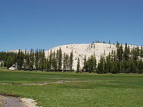
Pothole Dome is a granite dome on the West side of Tuolumne Meadows, in Yosemite National Park. The summit of the dome is easily accessible by foot from a parking area on the Tioga Road. The view from the summit includes most of Tuolumne Meadows and in the distance, Cathedral Peak. The dome gives evidence of many of the geologic processes at work in Yosemite during and after the last ice age. In particular, the stranded, rounded boulders from a glacier that has long since retreated, and the water-eroded "potholes" provide evidence of two ways that water can interact with granite.
Contents
Map of Pothole Dome, California, USA
View from pothole dome yosemite
References
Pothole Dome Wikipedia(Text) CC BY-SA