
Parent range Sierra Nevada Elevation 2,880 m Mountain range Sierra Nevada | Topo map USGS Tioga Pass Easiest route Hike, class 1 Prominence 88 m | |
 | ||
Similar Cathedral Peak, Pothole Dome, Mount Dana, Sentinel Dome, Fairview Dome | ||
Lembert dome hike yosemite national park
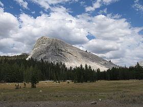
Lembert Dome is a granite dome rock formation in Yosemite National Park in the US state of California. The dome soars 800 feet (240 m) above Tuolumne Meadows and the Tuolumne River and can be hiked starting at the Tioga Road in the heart of Tuolumne Meadows, 8 miles (13 km) west of the Tioga Pass Entrance to Yosemite National Park.
Contents
- Lembert dome hike yosemite national park
- Map of Lembert Dome California USA
- Lembert dome yosemite national park ca
- References
Map of Lembert Dome, California, USA
Lembert Dome was named for Jean Baptiste Lembert, sometimes mistakenly referred to as John Lambert, who took up a homestead in a section of Tuolumne Meadows in 1865. By 1879 the Wheeler Survey referred to it as Soda Springs Dome. John Muir called it Glacier Rock.
Rock climbers can scale the face from the parking lot just off the Tioga Road, but hikers can simply walk up the back side or take the challenging steeper trek up the face starting from just east of the parking lot. Many technical free climbing routes have been put up.