
 | ||
History of pomona valley hospital medical center
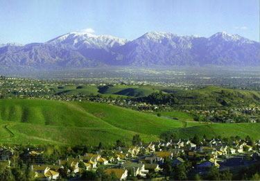
The Pomona Valley is located in the Greater Los Angeles Area between the San Gabriel Valley and San Bernardino Valley in Southern California. The valley is approximately 30 miles east of downtown Los Angeles, which can often be seen from nearby foothills. It ranges from the city of San Dimas from the far west to Rancho Cucamonga to the Far East portion of the valley. The alluvial valley is formed by the Santa Ana River and its tributaries.
Contents
- History of pomona valley hospital medical center
- Pomona valley hospital medical center women s children s center
- Communities
- Demographics
- Local interest
- Climate
- Institutions of higher learning
- International Airports
- Public transit
- Highways
- Major surface thoroughfares serving the Pomona Valley
- Newspapers serving the area
- References
The San Antonio Creek runs right through the center of the valley dividing the valley into west and east, and also acts as a section of the border between Los Angeles County and San Bernardino County. It originates from the San Gabriel Mountains watershed around Mount San Antonio (known locally as Mt. Baldy) and joins the Santa Ana River south of Chino. The Pomona Valley is separated from San Gabriel Valley to the west by the northeastern end of the San Jose Hills, running approximately along State Route 57. The eastern boundaries are the Jurupa Hills and the Cajon Pass, (the eastern end of the San Gabriel Mountains) running near Interstate 15, which separates the Pomona Valley from the San Bernardino Valley. The northern boundary is the San Gabriel Mountains. The Chino Hills is the southern boundary that separates the Pomona Valley from northern Orange County. Historic U.S. Route 66 runs east-west across the north side of Pomona Valley.
On March 1, 1893 the California Assembly voted 54-14 for a new county to form in the region, to be named San Antonio County, with Pomona as its seat. Los Angeles interests in the Senate rejected the concept, however, and today the eastern and western portions of the valley remain divided between San Bernardino and Los Angeles counties (San Antonio Creek).
Pomona valley hospital medical center women s children s center
Communities
The cities of Pomona Valley include:
Demographics
The residents of the Pomona Valley are predominantly White and Latino. In contrast to the San Gabriel Valley, the population of Asian Americans is much smaller. Northern areas of the valley that contain the cities of Claremont, La Verne, and San Dimas have large Caucasian populations. Southern portions of the valley that contain the cities of Pomona, Montclair, and Ontario have large Hispanic populations. Portions of the Pomona Valley such as Chino Hills, Diamond Bar, and Walnut contain rather large Asian populations.
Local interest
Climate
The Pomona Valley experiences a Mediterranean Climate. In contrast to much of the Greater Los Angeles Area, The Pomona Valley can get much hotter summers with high temperatures ranging from the triple digits. Due to its elevation ranging from 800 to 2200 feet, winters in the Pomona Valley can also get cold. Trace amounts of snowfall can occur anywhere above 1500 feet. On the valley floor, average rainfall amounts range anywhere from 12 to 16 inches. Foothill communities can get anywhere from 14 to 18 inches of rain a year. In the fall (fire season), Santa Ana Winds can occur giving strong offshore winds from the Cajon Pass.
Institutions of higher learning
International Airports
Public transit
Highways
The Pomona Valley is served by freeways:
Major surface thoroughfares serving the Pomona Valley
In Claremont, Mt. Baldy Road leads into the Mt. Baldy Ski Lifts of Mount San Antonio (nicknamed "Mt. Baldy") in the San Gabriel Mountains.