
 | ||
Portion of platte purchase bridge demolished
The Platte Purchase was a land acquisition in 1836 by the United States government from American Indian tribes. It comprised lands along the east bank of the Missouri River and added 3,149 square miles (8,156 km2) to the northwest corner of the state of Missouri.
Contents
- Portion of platte purchase bridge demolished
- Crews blast a section of the platte purchase bridge
- Purchase
- Settlement
- References
This expansion of the slave state of Missouri was in violation of the Missouri Compromise of 1820, which prohibited the extension of slavery in the former Louisiana Territory north of the parallel 36°30′ north except within the boundaries of the state of Missouri as defined at the time of the adoption of the Missouri Compromise. The area acquired was almost as large as the states of Delaware and Rhode Island combined, and extended Missouri north and westward along the river. St. Joseph, one of the main ports of departure for the westward migration of American pioneers, was located in the new acquisition.
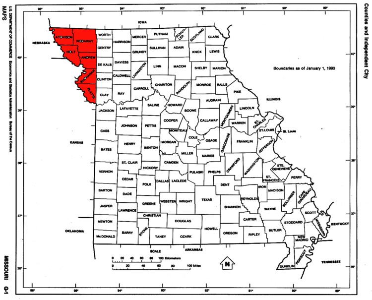
The region includes the following modern counties within its bounds: Andrew (435 square miles, 1127 km2), Atchison (545 square miles, 1412 km2), Buchanan (410 square miles, 1062 km2), Holt (462 square miles, 1197 km2), Nodaway (877 square miles, 2271 km2), and Platte (420 square miles, 1088 km2). It also includes the northwest suburbs of Kansas City, a small area of Kansas City proper, the cities of St. Joseph, Mound City and Maryville, Missouri, as well as Kansas City International Airport and almost all of Missouri's portion of Interstate 29, save the small portion which runs concurrently with Interstate 35 in Clay County.
Crews blast a section of the platte purchase bridge
Purchase
When Missouri entered the Union, its western border was established on the left bank of the Missouri River (the northern side as the river flows south) at the mouth of the Kaw River in Kansas City (94 degrees, 36 minutes west longitude)[1] (which is also the border between Missouri and Kansas). The purchase extended the Missouri border in the northwest to 95 degrees, 46 minutes west longitude.[2]
This addition increased the land area of what was already the largest state in the Union at the time (about 66,500 square miles (172,000 km2) to Virginia's 65,000 square miles, which then included West Virginia).[11] The acquisition challenged the Missouri Compromise of 1820 by expanding slavery into free territory north of the southern Missouri border with Arkansas (Parallel 36°30′ north) as well as the Indian Removal Act of 1830 in which tribes had just been moved west of the Missouri border "in perpetuity" as part of the painful Trail of Tears process.
In less than a year after the Indian Removal Act, the Missouri General Assembly was petitioning Congress to more clearly define the border on the northwest corner of the state. The Legislature noted the boundary was not clear, and that the land was not surveyed, thus leading to settlers encroaching on the lands. The most spectacular example of encroachment was Joseph Robidoux who had been operating an American Fur Company trading post at St. Joseph, Missouri since 1826.
On January 27, 1835, Senator Lewis F. Linn wrote John Dougherty, an Indian agent, to inquire about acquiring the land. Dougherty agreed, noting that the territory was preventing access to Missouri River shipping by Missouri residents east of the purchase line. Dougherty's reputation among the Native Americans was that he "controller of Fire-water" from the Missouri River to the Columbia River."
The first tribes to give up their land were the Potawatomi, who gave up their land in the Treaty of Chicago, which was agreed in 1833 but finalized in 1835. The Potawatomi (about 1,000 to 2,000) moved north to a reservation in Pottawattamie County, Iowa (Council Bluffs, Iowa). They moved again 1837–1838 in the Potawatomi Trail of Death to Osawatomie, Kansas.
The formal application came in the summer of 1835 when at a meeting on the Dawes farm near Liberty, Missouri, where the Indian agent for the Sac and Fox tribes, Andrew S. Hughes, presided over a meeting of Missouri residents who formally asked Congress to acquire the land. Missouri senator Thomas Hart Benton introduced a bill to acquire the land and it was approved with little opposition in June 1836.
An agreement was reached in 1836 with the chiefs Mahaska and No Heart of the Ioway tribe and leaders of the combined Sac and Fox tribes in a ceremony at Fort Leavenworth, Kansas that was presided by William Clark, then the Superintendent of Indian Affairs and based in St. Louis. (He was one of the leaders of the Lewis and Clark Expedition.)
The Senate approved the Treaty on February 15, 1837. On March 28, 1837, President Martin Van Buren issued a proclamation supporting the annexation. In October 1837 the Missouri General Assembly accepted the land and placed it all initially in the newly created Platte County.
The tribes were paid $7,500 for their land. The U.S. government was ″to provide agricultural implements, furnish livestock", and a host of other small items. The tribes agreed to move to reservations west of the Missouri River in what was to become Kansas and Nebraska. Furthermore, the U.S. government was to "build five comfortable houses for each tribe, break up 200 acres (0.8 km2) of land, fence 200 acres (0.8 km2) of land, furnish a farmer, blacksmith, teacher, interpreter″. The reservations are today known as the Ioway Reservation and the Sac and Fox Reservation. The tribes gave up 3.1 thousand square miles of land for a combined reservation of 29 square miles (26 for the Sac and Fox and 3 for the Ioway).
Michigan entered the union in January 1837 and so by the time the purchase was finalized Missouri remained the second biggest state.
Settlement
The U.S. Government set up a General Land Office in Plattsburg, Missouri to handle the settlement. Much of the dispensed as military land warrants to veterans of the War of 1812 (and later Mexican-American War) Under the terms of the program which was expanded in 1855 the 160-acre land grants could be given to military descendants and the grants be could sold.
Initial settlement was concentrated in the south in the Platte County area. Platte County almost overnight became the second largest county in the state and Weston, Missouri ("West Town") was second only to St. Louis, Missouri in the state. St. Joseph would subsequently became the second largest city in the state in the early settlement days. Since the purchase opened up new slave area, the area was heavily settled by slaveholders from Virginia, Tennessee and Kentucky. Southern crops that were slave intensive such as hemp and tobacco were grown in the southern portion. The settlement of the northern portion had fewer Southern settlers and slaves.
Today the Platte Purchase area is among the most rural areas in Missouri with St. Joseph and Maryville, Missouri being the only communities totally within the purchase area with populations greater than 10,000 (although Kansas City, Missouri has expanded its boundaries into southern Platte County).