
Elevation 2,982 m | Canton Graubünden Prominence 158 m | |
 | ||
Similar Piz Gannaretsch, Chrüzlistock, Piz Rondadura, Scopi, Monte Leone | ||
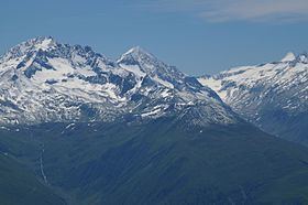
Piz Vatgira (2,982 m (9,783 ft)) is a mountain of the Lepontine Alps and part of the extended Saint-Gotthard Massif, located south of Sedrun in the canton of Graubünden. The mountain lies between the valleys of Nalps and Medel, about halfway between Lai da Nalps and Lai da Sontga Maria. On its east side is a small glacier ending in the lake named Lai Verd (2,702 m).
Map of Piz Vatgira, 7185 Tujetsch, Switzerland
Piz Vatgira, or more precisely a lower 2,981 metre-high summit 350 metres south of the main summit, lies exactly above the Gotthard Base Tunnel, at its deepest point. The tunnel, the longest and deepest in the world, runs about 2,300 metres (7,500 ft) below the ground. Piz Vatgira is the highest of the three main peaks above the base tunnel, the other two being the Chrüzlistock and Pizzo dell'Uomo.