
Surface elevation 1,908 m Catchment area 27.1 km² | Primary outflows Froda Surface area 1.77 km (0.68 sq mi) Area 177 ha | |
 | ||
Primary inflows | ||
Hinauf zum stausee lai da sontga maria
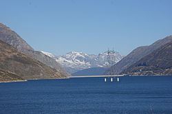
Lai da Sontga Maria (Italian: Lago di Santa Maria) is a lake, located north of the Lukmanier Pass in Switzerland. It lies almost entirely in the municipality of Medel (canton of Graubünden), a tiny fraction of the south-west part of the lake belonging to the municipalities of Quinto and Blenio (canton of Ticino). The reservoir has a surface area is 1.77 km2 (0.68 sq mi). The arch dam Santa Maria was completed in 1968. The main road of the Lukmanier Pass runs along the eastern shore of the lake.
Contents
- Hinauf zum stausee lai da sontga maria
- Map of Lai da Sontga Maria 7185 Medels im Oberland Switzerland
- References
Map of Lai da Sontga Maria, 7185 Medels im Oberland, Switzerland
The lake lies at a height of 1,908 metres above sea level and is surrounded by mountains over 3,000 metres on both sides. The highest peak overlooking Lai da Sontga Maria is the Scopi (3,190 m), on the east side. On the west side are Piz Gannaretsch (3,040 m) and Piz Rondadura (3,016 m). On the south side (in Ticino), the lake is overlooked by Pizzo dell'Uomo (2,663 m).
In the lake, there is an anchor pylon of Lukmanier Powerline.