
Area rank Ranked 5th Area 1,590 km² | ||
 | ||
Colleges and Universities Pembrokeshire College, Marine and Information Technology Centre Clubs and Teams Haverfordwest County A.F.C., St. Andrews F.C. Points of interest Folly Farm Adventure Park and, Oakwood Theme Park, Carew Castle, Manor House Wildlife P, Blue Lagoon Water Park Destinations | ||
Pembrokeshire (/ˈpɛmbrʊkʃɪər/, /ˈpɛmbrʊkʃər/, or /ˈpɛmbroʊkʃɪər/; Welsh: Sir Benfro [ˈsiːr ˈbɛnvrɔ]) is a county in the south west of Wales. It borders Carmarthenshire to the east and Ceredigion to the north east. Pembrokeshire County Council's headquarters are in the county town of Haverfordwest.
Contents
- Map of Pembrokeshire UK
- Geography
- Settlements
- Coastline
- Geology and landscape
- Wildlife
- History
- Middle Ages
- Modern period
- Ancient remains
- Population
- Languages
- Politics
- Transport
- Economy
- Agriculture
- Fishing
- Mining
- Oil and gas
- Renewable energy
- Tourism
- Flag
- Media
- Postal Addresses
- Sport
- Cuisine
- Notable people
- Filming location
- Education and health
- References
Map of Pembrokeshire, UK
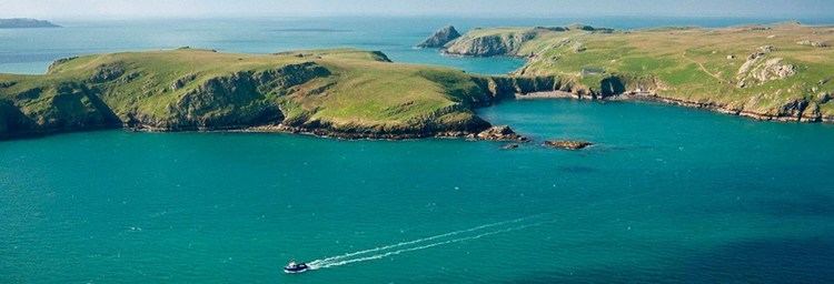
The county is home to Pembrokeshire Coast National Park, the only coastal national park of its kind in the United Kingdom and one of three national parks in Wales, the others being Snowdonia and the Brecon Beacons. Over the years Pembrokeshire's beaches have been received many International Blue Flag Awards, Green Coast Awards and Seaside Awards. In 2011 it had 39 beaches recommended by the Marine Conservation Society.
Industry is nowadays focused on agriculture and tourism, but historically mining and fishing were important activities. The county has a diverse geography and a complex history.
Pembrokeshire's population was 122,400 at the 2011 census, an increase of 7.2% from the 2001 figure of 114,131.
Geography
Pembrokeshire is bordered by the sea on three sides, and by the counties of Ceredigion to the north east and Carmarthenshire to the east.
Settlements
The county town is Haverfordwest. Other towns include Pembroke, Pembroke Dock, Milford Haven, Fishguard, Tenby, Saundersfoot, Narberth, Neyland and Newport. St David's, in the west of the county, is the United Kingdom's smallest city with a population of 2,000 (in 2010). Saundersfoot is the biggest village in Pembrokeshire with a population of well over 2,500.
See List of places in Pembrokeshire for a comprehensive list of settlements in Pembrokeshire.Coastline
The county's coastline includes internationally important seabird breeding sites and numerous bays and sandy beaches. Pembrokeshire contains a predominantly coastal park, Pembrokeshire Coast National Park, which includes a 186-mile walking trail, the Pembrokeshire Coast Path. A large estuary and natural harbour at Milford Haven cuts deeply into the coast; this inlet is formed by the confluence of the Western Cleddau (which goes through Haverfordwest), the Eastern Cleddau, and rivers Cresswell and Carew. The estuary is bridged by the large Cleddau Bridge (toll bridge) which carries the A477 between Neyland and Pembroke Dock; upstream bridges span the Cleddau at Haverfordwest and Canaston Bridge.
Large bays are Newport Bay, Fishguard Bay, St Bride's Bay and a portion of Carmarthen Bay. There are several small islands off the Pembrokeshire coast, the largest of which are Ramsey Island, Grassholm Island, Skomer Island and Caldey Island.
Geology and landscape
Pembrokeshire's diverse range of geological features was a key factor in the establishment of the Pembrokeshire Coast National Park and a number of sites of special scientific interest (SSSIs).
Rocks now found in Pembrokeshire were formed more than 290 million years ago; the youngest rocks, from the Carboniferous period, contain the Pembrokeshire Coalfield, the older rocks being Pre-Cambrian. Younger rocks have been lost by subsequent geological processes. The land on which Pembrokeshire is today was established approximately 60 million years ago by a combination of uplift and falling sea levels. The sea cliffs and inland tors that are now a feature of the county were those that were resistant to weathering that has taken place since. The landscape was subject to considerable change as a result of the ice ages over the last several thousand years, meltwater from which cut the river valleys seen across the county today. About 20,000 years ago the Irish Sea ice sheet deposited areas of clays. While Pembrokeshire is not a seismically active area, two periods of activity were noted in the 19th century. In 1873 there was a double shock (intensity: 4) in the west of the county, and a series of more pronounced activity (maximum intensity: 7) over a six-day period in August 1892.
In the north of the county are the Preseli Hills (Mynydd Preseli), a wide stretch of high moorland supporting sheep farming and some forestry, with many prehistoric sites and the probable source of the bluestones used in the construction of the inner circle of Stonehenge in England. The highest point is Foel Cwmcerwyn at 1,759 feet (536 m), which is also the highest point in Pembrokeshire. Elsewhere in the county most of the land is used for farming of dairy cows, arable crops, oil seed rape, and the well-known Pembrokeshire potato.
Wildlife
Pembrokeshire's wildlife is diverse, with marine, estuary, ancient woodland, moorland and farmland habitats all within the county. The response to an appeal for otter sightings in 2014 yielded more than 100 sightings. Seals whales, dolphins and porpoises can be seen frequently off the Pembrokeshire coast.
History
Human habitation of the region of Pembrokeshire extends back to 125,000 and 70,000 BCE. By the late Roman Empire period, an Irish tribe known as the Déisi settled in the region between 350 and 400, with their realm known as Demetae. In the post-Roman period, the Irish Déisi merged with the local Welsh, with the regional name underlying Demetae evolving into Dyfed, which existed as an independent petty kingdom until its heiress, Elen, married Hywel Dda in 904. Hywel merged Dyfed with his own maternal inheritance of Seisyllwg, forming the new realm of Deheubarth ("southern district"). The region suffered from devastating and relentless Viking raids during the Viking Age, with the Vikings establishing settlements and trading posts at Haverfordwest, Fishguard and Caldey Island.
Middle Ages
Dyfed, the region of Pembrokeshire, remained an integral province of Deheubarth, but this was contested by invading Normans and Flemings who arrived between 1067 and 1111. The region became known as Pembroke (sometimes archaic "Penbroke"), after the Norman castle built in the cantref of Penfro. In 1136 Prince Owain Gwynedd sought to avenge the execution of his sister, Gwenllian ferch Gruffydd, and her children; with Gwenllian's husband the Prince Rhys, he swept down from Gwynedd with a formidable army, and at Crug Mawr near Cardigan met and destroyed a 3,000-strong Norman/Flemish army. The remnants of the Normans fled across the bridge at Cardigan which collapsed and the Teifi river is said to have been choked with drowned men-at-arms and horses. Owain's brother Cadwallader took de Clare's daughter Alice as his wife. Owain incorporated Deheubarth into Gwynedd, re-establishing control of the region. Mortally weakened Norman/Flemish influence never fully recovered in West Wales. Princess Gwenllian is one of the best-remembered victims.
In 1138 the county of Pembrokeshire was named as a county palatine. Rhys ap Gruffydd, Gwenllian's son, re-established Welsh control over much of the region and threatened to retake all of Pembrokeshire, but died in 1197. After Deheubarth was split by a dynastic feud, Llywelyn the Great almost succeeded in retaking the region of Pembroke between 1216 and his death in 1240.
In 1457 Henry Tudor was born at Pembroke Castle. He landed an army not far from his birthplace 28 years later in 1485; he rallied support, marched to Leicestershire and defeated the larger army of Richard III at the Battle of Bosworth Field. As Henry VII of England, he founded the House of Tudor, a dynasty that ruled England until 1603.
The Laws in Wales Act 1535 divided the county into hundreds, which followed with some modifications the boundaries of the cantrefi, ancient jurisdictions which went back to before the Norman conquest. The hundreds were (clockwise from the northeast): Cilgerran or Kilgerran, Cemais or Kemes, Dewisland or Dewsland, Roose, Castlemartin, Narberth and Dungleddy (Daugleddau). Each hundred was divided into a number of civil parishes.
During the First English Civil War (1642–1646) the county gave strong support to the Roundheads (Parliamentarians), in sharp contrast to the rest of Wales, which was staunchly Cavalier (Royalist). In spite of this an incident in Pembrokeshire triggered the opening shots of the Second English Civil War when local units of the New Model Army mutinied. Oliver Cromwell defeated the uprising at the Siege of Pembroke in July 1648. On 13 August 1649 the Cromwellian conquest of Ireland began when its forces sailed from Milford Haven.
Modern period
In 1791 a petition was presented to the House of Commons concerning the poor state of many of the county's roads, pointing out that repairs could not be made compulsory by the law as it stood. The petition was referred to committee.
There has been considerable military activity in Pembrokeshire in the 20th century: for example, military exercises in the Preseli Hills and a number of former military airfields. Military and industrial targets in the county were subjected to bombing during World War II.
Ancient remains
Pembrokeshire has numerous prehistoric (such as Pentre Ifan) and historic places, including a number of almost-complete and ruined castles dating from Norman times. Other important sites include Big House, Penrhos Cottage, Slebech Park, St David's Cathedral and Strumble Head Lighthouse.
There are many known shipwrecks off the Pembrokeshire coast. The county has six lifeboat stations, the earliest of which was established in 1822; in 2015 a quarter of all Royal National Lifeboat Institution Welsh rescues took place off the Pembrokeshire coast.
Population
Pembrokeshire's population was 122,400 at the 2011 census, an increase of 7.2% from the 2001 figure of 114,131.
Languages
As a result of differential immigration over hundreds of years, the south of the county has more English-speaking inhabitants, while Welsh is more widely spoken in the north. The rough line that can be drawn between the two regions, illustrated by the map (right), is known as the Landsker Line. The first objective, statistically based description of the "frontier" was made in the 1960s, but the distinction was remarked upon as early as 1603 by George Owen of Henllys.
Politics
Under the Local Government Act 1888, an elected county council was set up to take over the functions of the Pembrokeshire Quarter Sessions. This and the administrative county of Pembrokeshire were abolished under the Local Government Act 1972, with Pembrokeshire forming two districts of the new county of Dyfed: South Pembrokeshire and Preseli – the split being made at the request of local authorities in the area. In 1996, under the Local Government (Wales) Act 1994, the county of Dyfed was broken up into its constituent parts, and Pembrokeshire has been a unitary authority since then.
There are 80 local Communities (the successors to civil parishes) in the county which have their own councils; see the foot of this page for a list of Communities.
Transport
The main towns in the county are covered by regular bus and train services, and many villages by local bus services, or community or education transport.
There are no motorways in Pembrokeshire. The nearest motorway to the county town of Haverfordwest is the M4 which terminates at Pont Abraham in Carmarthenshire, some 46 miles (74 km) to the east. The A40 crosses Pembrokeshire from the border with Carmarthenshire westwards to Haverfordwest, then northwards to Fishguard. The road is used heavily by tourists and traffic from the ferry port at Fishguard; some improvements have been made since the 1990s but others were still the subject of discussion in 2014. The A477 which runs from St. Clears to Pembroke Dock is 24 miles (39 km) long, of which only 2 miles (3 km) are dual carriageway. The road has been improved in recent years. The Cleddau Bridge carries the A477 connecting South Pembrokeshire with North Pembrokeshire across the Cleddau Estuary. The A478 traverses eastern Pembrokeshire from Tenby in the south to Cardigan, Ceredigion in the north, a distance of 30 miles (48 km). The A487 is the other major route, running north-west from Haverfordwest to St David's, then north-east following the coast, through Fishguard and Newport, to the boundary with Ceredigion at Cardigan. Owing to width restrictions in Fishguard, some freight vehicles are not permitted to travel north-east from Fishguard but must take a longer route via Haverfordwest and Narberth. The B4329 former turnpike runs from Eglwyswrw in the north to Haverfordwest across the Preseli Mountains.
The West Wales branch railway lines, terminating at Pembroke Dock and Milford Haven, have two-hourly services. The Fishguard branch has seven services each weekday; two are timed to meet the Stena Line ferry to and from Rosslare Europort in Ireland at Fishguard Harbour. From Rosslare Europort, trains connect with Dublin Connolly run by Iarnród Éireann on the Dublin–Rosslare railway line. Irish Ferries run from Pembroke Dock to Rosslare Europort and seasonal ferry services operate from Tenby to Caldey Island, from St Justinians, St Davids, to Ramsey Island and Grassholm Island, and from Martin's Haven to Skomer Island. Haverfordwest (Withybush) Airport provides general aviation services. Pembrokeshire is connected via the West Wales Lines to Swansea and from there by the main line to Cardiff and Paddington. Direct trains from Milford Haven run to Manchester Piccadilly.
Economy
Pembrokeshire's economy now relies heavily on tourism; agriculture, once its most important industry with associated activities such as milling, is still significant. Mining of slate and stone, once widespread, had largely ceased by the 20th century. Since the 1950s, petrochemical and liquid natural gas industries have developed along the Milford Haven Waterway.
Agriculture
Until the 12th century, much of Pembrokeshire was virgin woodland. Clearance in the lowland south began under Anglo-Flemish colonisation and under mediaeval tenancies in other areas. Such was the extent of development that by the 16th century there was a shortage of timber in the county. Little is known about mediaeval farming methods, but much arable land was continuously cropped and only occasionally ploughed. By the 18th century, many of the centuries-old open field systems had been enclosed, and much of the land was arable or rough pasture in a ratio of about 1:3.
Kelly's Directory of 1910 gave a snapshot of the agriculture of Pembrokeshire: 57,343 acres were cropped (almost half under oats and a quarter barley), there were 37,535 acres of grass and clover and 213,387 acres of permanent pasture (of which a third was for hay). There were 128,865 acres of mountain or heathland used for grazing, with 10,000 acres of managed or unmanaged woodland. Estimates of livestock included 17,810 horses, 92,386 cattle, 157,973 sheep and 31,673 pigs. Of 5,981 agricultural holdings, more than half were between 5 and 50 acres.
Pembrokeshire had a flourishing wool industry. There are still working woollen mills at Solva and Tregwynt.
Pembrokeshire has good soil and benefits from the Gulf Stream, which provides a mild climate and a longer growing season than other parts of Wales. Pembrokeshire's mild climate means that crops such as its new potatoes (which have protected geographical status under European law) often arrive in British shops earlier in the year than produce from other parts of the UK. Other principal arable crops are oilseed rape, wheat and barley, while the main non-arable activities are dairy farming for milk and cheese, beef production and sheep farming.
The county lends its name to the Pembroke Welsh Corgi, a herding dog whose lineage can be traced back to the 12th century, but which in 2015 was designated as a "vulnerable" breed.
Fishing
With much of Pembrokeshire being coastline or tidal river estuaries, fishing was an important industry at least from the 16th century, with many ports and villages dependent on the industry before it declined. The former large sea fishing industry around Milford Haven is now greatly reduced, although limited commercial fishing still takes place. At its peak, Milford was landing over 40,000 tons of fish a year. Pembrokeshire Fish Week is an annual event which in 2014 attracted 31,000 visitors and generated £3 million for the local economy.
Mining
Slate quarrying was a significant industry in the 19th and early 20th centuries with quarrying taking place at about 100 locations throughout the county. Over 50 coal workings were in existence between the 14th and 20th centuries, with the last Pembrokeshire coal mine, at Kilgetty, closing in 1950.
Oil and gas
The banks of the Milford Haven Waterway are dominated by the oil and gas industry with two oil refineries, two large liquified natural gas (LNG) terminals and the new 2000 MW gas-fired Pembroke Power Station under construction on the site of an oil-fired power station which was closed in 1997 and demolished in 2000.
The two oil refineries in Pembrokeshire are:
At the peak, there were a total of five refineries served from around the Haven.
The LNG terminals on the north side of the river, just outside Milford Haven were opened in 2008; a controversial pipeline connecting Milford Haven to Tilbury in Gloucestershire was completed in 2007.
Renewable energy
The Pembrokeshire Coast National Park Authority has identified a number of areas in which renewable energy can be, and has been, generated in the county. Following several years of planning after the initial impact studies begun in 2011, the first submarine turbine of three was installed in Ramsey Sound in December 2015. The cumulative impact of single and multiple wind turbines is not without controversy and was the subject of a comprehensive assessment in 2013. In 2011 the first solar energy farm in Wales was installed at Rhosygilwen, Rhoshill with 10,000 panels in a field of 6 acres (2.4 ha).
Tourism
In 2010 4.2 million tourists visited the county, staying for an average of 3.3 days, spending £544 million; the tourism industry supported 16,300 jobs. Many of Pembrokeshire's beaches have been awarded International Blue Flag Awards: 11 in 2015. There were 12 Green Coast Awards and 19 Seaside Awards in 2015. A major draw to tourists is the Pembrokeshire coastline; in 2011 National Geographic Traveller magazine voted the Pembrokeshire coast the second best in the world and in 2015 the Pembrokeshire Coast National Park was listed among the top five parks in the world by a travel writer for the Huffington Post. The many wrecks off the Pembrokeshire coast attract divers.
The county has a number of theme and animal parks (Folly Farm Adventure Park and Zoo, Manor House Wildlife Park, Blue Lagoon Water Park and Oakwood Theme Park), museums such as Pembrokeshire Motor Museum and other visitor attractions including Castell Henllys reconstructed Iron age fort, Tenby Lifeboat Station and Milford Haven's Torch Theatre.
Flag
The flag of Pembrokeshire consists of a yellow cross on a blue field. In the centre of the cross is a green pentagon bearing a red and white Tudor rose. The rose is divided quarterly and counterchanged: the inner and outer roses have alternating red and white quarters.
Media
There are seven local newspapers based in Pembrokeshire: the Western Telegraph (the largest in Pembrokeshire), The Milford Mercury, Tenby Observer, Pembroke Observer, County Echo and The Pembrokeshire Herald (founded 2013). The Milford Mercury (circulation 3,681) and Western Telegraph (circulation 19,582) are part of the Newsquest group. Pembrokeshire's Best Magazine was launched in 2011. Narberth is home to Radio Pembrokeshire, Radio Carmarthenshire and Scarlet FM broadcasting to listeners every week.
Postal Addresses
In 2009, the question of county names and Royal Mail postal addresses was raised in parliament; it was argued that Royal Mail's continued use of the county address Dyfed was causing concern and confusion in the Pembrokeshire business community.
Sport
As the national sport of Wales, rugby union is widely played throughout the county at both town and village level. Haverfordwest RFC ,founded in 1875, is a feeder club for Llanelli Scarlets. Village team Crymych RFC in 2014 plays in WRU Division One West.
Triathlon event Ironman Wales was hosted by Pembrokeshire for the third year running in 2013, contributing an estimated £4 million to the local economy. Ras Beca, a mixed road, fell and cross country race attracting UK-wide competitors, has been held in the Preseli Mountains annually since 1977. The record of 32 minutes 5 seconds has stood since 1995. Pembrokeshire Harriers athletics club was formed in 2001 by the amalgamation of Cleddau Athletic Club (established 1970) and Preseli Harriers (1989) and is based in Haverfordwest.
The annual Tour of Pembrokeshire road-cycling event takes place over 50, 75 or 100 miles. The 4th Tour, in April 2015, attracted 1,600 riders including Olympic gold medallist Chris Boardman and there were 1,500 entrants to the 2016 event. Part of Route 47 of the Celtic Trail cycle route is in Pembrokeshire. The Llys y Fran Hillclimb is an annual event run by Swansea Motor Club.
Abereiddy's Blue Lagoon was the venue for a round of the Red Bull Cliff Diving World Series in 2012, 2013 and 2016; the Welsh Surfing Federation has held the Welsh National Surfing Championships at Freshwater West for several years and Llys y Fran Country Park hosted the Welsh Dragonboat Championships from 2014 to 2016.
While not at major league level, cricket is played throughout the county and many villages such as Lamphey, Creselly, Llangwm, Llechryd and Crymych field teams in minor leagues under the umbrella of the Cricket Board of Wales.
Cuisine
Pembrokeshire is well known for its excellent food, having capitalised on the quality of its agricultural produce. This abundance of produce and food outlets means that the county can "satisfy even the pickiest palate". In 2013 the Pembrokeshire Early Potato was awarded Protected Geographical Indication (PGI) status by the European Commission.
Notable people
See also Category:People from PembrokeshireIn the arts, siblings Gwen and Augustus John were both born in Pembrokeshire. Graham Sutherland painted locally in the 1930s, gaining inspiration from the landscape. The novelist Sarah Waters was born and brought up in Pembrokeshire and actors Rhys Ifans and Christian Bale were born in Withybush Hospital in the county. Singers Duffy and Connie Fisher both grew up in Pembrokeshire.
Stephen Crabb, former Secretary of State for Work and Pensions and Secretary of State for Wales, was brought up in Pembrokeshire and represents the county as one of its two Members of Parliament.
Filming location
Pembrokeshire's coastal landscape and wealth of historic buildings has made it a popular location choice for television and film, including Moby Dick at Fishguard in 1956 and Harry Potter and the Deathly Hallows at Freshwater West in 2010. Others include (click on "show" to see the full list):
Education and health
There are some 61 primary and 8 secondary schools in Pembrokeshire. A comprehensive review of education in Pembrokeshire was carried out in 2014 with a number of options for discussion in 2015. The Preseli Branch of the University of the Third Age (U3A) provides musical appreciation as a subject, but suffers from the library service not having a catalogue of the CDs in stock.
Health services in the county are provided by Hywel Dda Local Health Board which also provides for Ceredigion and Carmarthenshire. The county's principal hospital is Withybush General Hospital in Haverfordwest, and there are local hospitals in Tenby and Pembroke Dock.