
Listing Marilyn, Council top Topo map OS Landranger 145 Prominence 344 m Parent range Preseli Hills | OS grid SN094311 Elevation 536 m | |
 | ||
Pronunciation Welsh: [ˈvɔil kʊmˈkɛɾwɪn] Similar Carn Menyn, Brandy Hill - Wales, Chwarel y Fan, Fan Brycheiniog, Rhos Fawr | ||
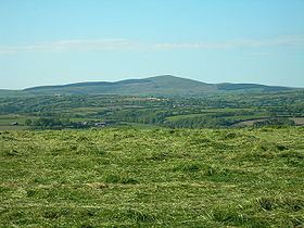
Foel Cwmcerwyn is the highest point of the Preseli Hills and of Pembrokeshire. It lies within the borders of the Pembrokeshire Coast National Park although it is 10 km from the sea. A path leads to the summit from the village of Rosebush in the south-west. A trig point and a number of cairns are dotted across the summit area, and there is a disused quarry on the hill's western slopes.
Map of Foel Cwmcerwyn, Clynderwen, UK
References
Foel Cwmcerwyn Wikipedia(Text) CC BY-SA